Cox Ford Covered Bridge facts for kids
Quick facts for kids Cox Ford Covered Bridge |
|
|---|---|

Cox Ford Bridge
|
|
| Coordinates | 39°53′7.6″N 87°13′25.64″W / 39.885444°N 87.2237889°W |
| Carries | Cox Ford Road |
| Crosses | Sugar Creek |
| Locale | Sugar Creek, Indiana, Parke, Indiana, United States |
| Official name | Cox Ford Covered Bridge |
| Named for | Cox Ford |
| Maintained by | Parke County Commissioners Parke County |
| WGCB # | 14-61-34 |
| Characteristics | |
| Design | Burr arch truss bridge |
| Material | Concrete on top of stone block (foundations) |
| Trough construction | Wood |
| Total length | 176 ft (53.6 m) (includes 8 ft (2.4 m) overhangs on each end) |
| Width | 16 ft (4.9 m) |
| Longest span | 160 ft (48.8 m) |
| Number of spans | 1 |
| Clearance above | 13 ft (4.0 m) |
|
Cox Ford Covered Bridge (#7)
|
|
|
U.S. Historic district
Contributing property |
|
| Lua error in Module:Location_map at line 420: attempt to index field 'wikibase' (a nil value). | |
| Built | 1913 |
| Built by | Joseph A. Britton |
| Part of | Parke County Covered Bridges TR (ID64000193) |
| NRHP reference No. | 78000390 |
| Added to NRHP | December 22, 1978 |
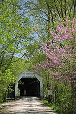
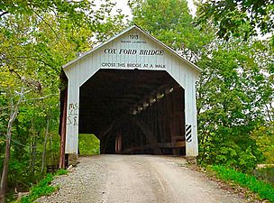
The Cox Ford Covered Bridge is a famous covered bridge in Parke County, Indiana. It crosses Sugar Creek right next to Turkey Run State Park. This beautiful bridge is a great example of old-time engineering and history.
The Bridge's Story
This bridge was built in 1913 by a skilled builder named Joseph A. Britton. It's a special type called a Burr arch truss bridge. This design uses strong wooden arches to help support the bridge, making it very sturdy.
The Cox Ford Bridge is about 160 feet (49 meters) long. If you include the parts that hang over each end, it's 176 feet (54 meters) long. It's wide enough for cars, about 16 feet (4.9 meters) across, and has a clearance of 13 feet (4 meters) high.
A Bridge with a Unique Past
What makes this bridge really interesting is its unique past. It was built to replace a steel bridge that was destroyed in a big flood in 1913. Even more amazing, the strong wooden arches used to build the Cox Ford Bridge came from another bridge! These arches were originally part of the Armiesburg Covered Bridge, which was built 60 years earlier and also washed away in that same 1913 flood. It's like the old arches got a second chance!
Preserving History
During the Great Depression, a time when many people needed jobs, a group called the Works Progress Administration (WPA) helped give the Cox Ford Covered Bridge a fresh coat of paint. This helped keep the bridge looking good and lasting longer.
In 1978, the bridge was added to the National Register of Historic Places. This is a special list of places in the United States that are important to history. Being on this list helps protect the bridge and makes sure it's remembered for future generations.
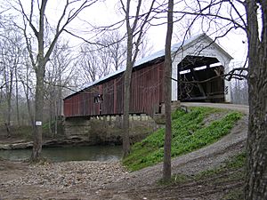
Gallery
-
Portal detail
-
-