Coyote Creek (Long Tom River tributary) facts for kids
Quick facts for kids Coyote Creek |
|
|---|---|

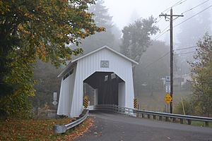
Coyote Creek Bridge carries Battle Creek Road over the stream near Crow.
|
|
|
Location of the mouth of Coyote Creek in Oregon
|
|
| Country | United States |
| State | Oregon |
| County | Lane |
| Physical characteristics | |
| Main source | Hills south of Eugene near Gillespie Corners 980 ft (300 m) 43°54′41″N 123°10′37″W / 43.91139°N 123.17694°W |
| River mouth | Long Tom River Fern Ridge Reservoir 377 ft (115 m) 44°03′26″N 123°16′28″W / 44.05722°N 123.27444°W |
Coyote Creek is a cool stream in Oregon, USA. It flows into the Long Tom River. This happens at a big lake called Fern Ridge Reservoir. The creek is located in Lane County.
It starts in the hills south of Eugene. Then it winds its way north. It passes through small towns like Gillespie Corners and Crow. Finally, it reaches the Fern Ridge Reservoir near Veneta.
The Famous Covered Bridge
A little way upstream from Crow, you'll find a special bridge. It's called the Coyote Creek Bridge. This bridge is a "covered bridge." That means it has a roof and sides, like a small house! It helps protect the wooden structure from weather.
The bridge carries Battle Creek Road over the creek. It's so old and important that it was added to the National Register of Historic Places in 1979. This means it's a historic landmark!
What Are Tributaries?
A tributary is a smaller stream or river. It flows into a larger stream or river. Coyote Creek has many tributaries. These smaller streams add water to the main creek. They help make it bigger as it flows.
Coyote Creek's Tributaries
Many smaller streams join Coyote Creek along its path. From where the creek starts to where it ends, these are some of its named tributaries:
- Rebel Creek
- Jackson Creek
- Doak Creek
- Fox Hollow
- Bear Creek
- Beaver Creek
- Powell Creek
- Hayes Branch
- Jordan Creek
- Nighswander Creek
- Battle Creek
- Sturtevant Creek
- Spencer Creek
 | William L. Dawson |
 | W. E. B. Du Bois |
 | Harry Belafonte |


