
Croche Lake (Sainte-Thècle) facts for kids
Quick facts for kids Croche Lake |
|
|---|---|

Croche Lake
Location in Quebec
|
|
| Location | Sainte-Thècle, Quebec |
| Coordinates | 46°49′55″N 72°30′00″W / 46.83194°N 72.50000°W |
| Lake type | Natural |
| Primary inflows | Discharge of "Lac des tounes" (located at Nord-East) |
| Primary outflows | outlet of Croche Lake (located at the South-West) |
| Basin countries | Canada |
| Max. length | 3.9 km (2.4 mi) |
| Max. width | 0.35 km (0.22 mi) |
| Surface area | 79.32 hectares (196.0 acres) |
| Max. depth | 26.52 m (87.0 ft) |
| Settlements | Sainte-Thècle |
Croche Lake (French: Lac Croche) is a beautiful lake in Sainte-Thècle, Quebec, Canada. It is part of the Mekinac Regional County Municipality in the Mauricie area.
For a long time, people used the land around Croche Lake for logging and farming. Starting in the mid-1900s, it became a popular spot for vacations. Today, many people visit the lake for fun outdoor activities and tourism.
Contents
What's in a Name? The Story of Croche Lake
The name "Croche" means "crooked" or "bent" in French. Many places in Quebec were named "Croche" because of their shape. This caused some confusion, as many lakes and rivers had the same name.
Because of this, many "Lac Croche" names are slowly being changed. They are getting new names that are easier to tell apart. The name "Lac Croche" for this lake was officially recorded on December 5, 1968. This was done by the Commission de toponymie du Québec, which is like Quebec's official place-naming board.
Exploring Croche Lake's Geography
Croche Lake in Sainte-Thècle is one of several lakes lined up from north to south. These lakes stretch between Hervey-Jonction and Saint-Tite. Some of the other lakes in this chain include Heart Lake and Snags Lake.
Croche Lake and Snags Lake are at the bottom of a long cliff. This cliff runs along the east side of the lake chain.
How Big is Croche Lake?
Croche Lake is quite long, about 3.9 kilometers (2.4 miles) in total. This includes a narrow part near the lake's exit. The northern part of the lake is the widest. It looks a bit like a large, slightly bent cucumber. This section is about 2.4 kilometers (1.5 miles) long and 0.32 kilometers (0.2 miles) wide.
A narrow passage, about 0.53 kilometers (0.33 miles) long, connects the northern and southern parts of the lake. The name "Croche" (crooked) really fits this winding passage. The southern part of the lake is shaped like a boot. It is about 0.45 kilometers (0.28 miles) long and 0.35 kilometers (0.22 miles) wide. A large, lit fountain is in the middle of this southern section.
Water Flow and Nearby Lakes
Heart Lake, located northwest of Hervey-Jonction, is the starting point for Heart River. This river flows south into Lake of Tunes. The water from Lake of Tunes then flows north into Croche Lake.
The water from Croche Lake exits from its southwest side. It flows into a stream that connects to Snags Lake. This stream eventually joins the Rivière des Envies (River of Desires).
Fun at St. Jean Optimist Park
St. Jean Optimist Park is on the southeast side of Croche Lake. It is right in the heart of Sainte-Thècle village. This park is a popular spot for both locals and visitors, especially in summer.
The park has a lovely beach where you can relax. There are also picnic tables and play areas for children. It's a great place for public events too. The Laurent Naud waterfront path runs from Bridge Street to the park. From this path, you can enjoy beautiful views of the lake.
A Look Back: Croche Lake's History
Settlers began arriving in Sainte-Thècle around 1867. They started clearing land along the west side of Snags Lake and Croche Lake. At first, there was only a basic road connecting Saint-Tite to the new forest settlements further north.
Winter Travel on the Ice
Before proper roads and bridges were built, people used ice roads on Croche Lake and Snags Lake in winter. This allowed families to travel to Saint-Tite, which was the main town for shopping. They also used these ice roads to reach logging camps. In summer, settlers used small boats to get around.
Logging and Sawmills
Croche Lake was important for floating logs. These logs were sent to the sawmill owned by Theophile Magnan and his son Napoleon Magnan. Their sawmill was built near the lake's exit, close to the dam.
The Covered Bridge and Ice Cutting
A covered bridge used to cross Croche Lake. It connected the Saint-Michel North area with Bridge Street in the lower village. This covered bridge was taken down in July 1955. A new, modern bridge was built in its place.
During the coldest parts of winter, men would cut large blocks of ice from Croche Lake. They used hand saws and special hooks to lift the ice. This ice was then used to fill coolers for people living in the village and nearby areas. There was a public building near the lake, by Tessier Street, where this ice was stored.
Images for kids
-
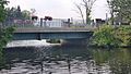
Bridge on rue Dupont, spanning Lac Croche in village of Sainte-Thècle.

