Rivière des Envies facts for kids
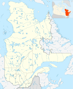
Quick facts for kids Rivière des Envies, La Mauricie, QC |
|
|---|---|

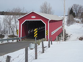
Bordeleau bridge on Rivière des Envies, at the limit of Saint-Tite, Saint-Séverin and Hérouxville
|
|
| Country | Canada |
| Regional County Municipality | Mékinac Regional County Municipality |
| Municipalities | Saint-Stanislas (Les Chenaux), Saint-Séverin, Saint-Tite, Sainte-Thècle |
| Physical characteristics | |
| Main source | Discharge of Lake Traverse Sainte-Thècle, Mauricie, Province of Québec, Canada 165 m (541 ft) 46°50′53″N 72°32′02″W / 46.84806°N 72.53389°W |
| River mouth | Saint-Stanislas (Les Chenaux) Quebec, Batiscanie, Canada 100 m (330 ft) 46°50′53″N 72°24′00″W / 46.84806°N 72.40000°W |
| Length | 74 km (46 mi) |
| Discharge (location 2) |
|
| Basin features | |
| Basin size | 482 km2 (186 sq mi) |
| Tributaries |
|
The Rivière des Envies is a river located in Quebec, Canada. Its name means "River of Cravings" in English. This river flows through the Mauricie region and is an important part of the Batiscanie area.
The Rivière des Envies is about 74 kilometers (46 miles) long. It starts from Lake Traverse in Sainte-Thècle. This lake gets its water from Lake Aylwin, which is fed by Lake Jesuit and other nearby mountain lakes.
The area drained by the Rivière des Envies is 482 square kilometers (186 square miles). This makes it the second-largest river basin in Batiscanie. The river basin is shared by three different regional county municipalities:
- The Mékinac Regional County Municipality (including Sainte-Thècle, Saint-Tite, Hérouxville, and Saint-Séverin).
- The Shawinigan Regional County Municipality (for Lac-à-la-Tortue).
- The Les Chenaux Regional County Municipality (for Saint-Stanislas (Les Chenaux)).
Even though Saint-Adelphe is near the river, most of its land is not part of this river's watershed. Only a small area to the southwest, near Saint-Stanislas, is included.
Contents
The River's Journey: Where Does It Flow?
The Rivière des Envies flows through several towns and areas. It starts in Sainte-Thècle, then goes through Saint-Tite. It also touches the eastern edge of Hérouxville for about 4 kilometers.
After that, it passes through Saint-Séverin and finally Saint-Stanislas (Les Chenaux). The river ends by flowing into the Batiscan River at the southern edge of Saint-Stanislas.
Most of the river's path is through farmland. However, between Sainte-Thècle and Saint-Tite, it flows through a forest. Downstream from Saint-Tite, there are still some smaller forest areas. The river also goes right through the villages of Saint-Tite, Saint-Séverin, and Saint-Stanislas.
During spring, when snow melts, the river can flood. This often happens upstream of the railway bridge in Saint-Tite. The river has a very winding path from Sainte-Thècle to Saint-Tite, especially in the "Grands marais" (large marshes) area. This marshy area was once home to beavers and moose, which likely attracted early Indigenous peoples.
River Helpers: Major Tributaries
Many smaller streams and rivers flow into the Rivière des Envies. These are called tributaries. They add water to the main river. Here are some of the most important ones:
Tributaries on the Left Side
- Lake-aux-Chicots Outlet: This stream in Sainte-Thècle brings water from the "rivière en coeur" (river in heart). The "rivière en coeur" starts at "Lac en coeur" (lake in heart) and flows through "Lac des tounnes" and "Lac Croche" (crooked lake).
- Le Bourdais Creek: This creek is found in Saint-Tite.
- Stream of Fools (ruisseau des fous): Also located in Saint-Tite.
- Second Dick Creek: Another creek in Saint-Tite.
Tributaries on the Right Side
- Archange Creek: This creek in Saint-Tite starts from Lake Archange.
- Eric Creek: Also in Saint-Tite, it joins the Rivière des Envies just before the North Mékinac River.
- North Mékinac River: This important river in Saint-Tite flows into the Rivière des Envies about 4.2 kilometers (2.6 miles) upstream from Saint-Tite. The South Mékinac River also flows into the North Mékinac River.
- Dessureault Creek: This creek is in Saint-Stanislas (Les Chenaux).
- Turtle River (rivière à la tortue): This river also joins in Saint-Stanislas (Les Chenaux).
The two most significant rivers that flow into the Rivière des Envies are the North Mékinac River and the Turtle River.
Water Sources: Major Lakes
Several lakes feed the Rivière des Envies, either directly or through its tributaries. Here are the main ones, grouped by municipality:
- Sainte-Thècle:
- Lake Jesuit (Lac du Jésuite)
- Lake de la Traverse
- Lake Croche
- Lake-aux-Chicots
- "Lake-des-Tounes"
- Saint-Tite:
- Lake Archange
- Lake-à-la-perchaude
- Lake Trottier
- Lake Éric
- Lake Roberge
- Shawinigan (near Lac-à-la-Tortue):
- Turtle Lake (Lac-à-la-Tortue)
Southwest of Saint-Tite, the Rivière des Envies once formed a lake called Lake Kapibouska. This lake was likely created by beaver dams, but it no longer exists. The river's watershed also includes about half of a large wetland area southeast of Lac-à-la-Tortue.
The River's Name: Where Did "Rivière des Envies" Come From?
The name "Rivière des Envies" was first written down in 1757. This was in a document by a Jesuit brother named Jean-Joseph Casot. This was even before the first settlers arrived in the Saint-Stanislas area near the river.
In 1760, eleven families of pioneers settled in the Batiscan manor, specifically in the "Rivière-des-Envies" area of Saint-Stanislas. In 1776, a priest named Father Guay visited these settlers.
In 1781, the Jesuits oversaw the building of a flour mill at the mouth of the Rivière des Envies. The local church parish was officially created in 1833 and named Saint-Stanislas-de-la-Rivière des Envies.
The name "Rivière des Envies" has been used consistently throughout history in official documents. While there are many ideas about how the name started, there isn't clear proof for any of them. The name "Rivière des Envies" was officially recognized on December 5, 1968, by the Quebec Geographical Names Board.
When the River Rises: Major Floods
Every spring, when the snow melts, the Rivière des Envies can experience big floods. These floods have a greater impact in the winding parts of the river upstream of the railway bridge in Saint-Tite. Heavy, long-lasting rains can also cause major floods.
Here are some notable floods:
- September 1924: Heavy rains for a week caused many bridges over the river to be washed away, from Sainte-Thècle all the way to Saint-Stanislas. The village of Saint-Tite and the area upstream were flooded. A newspaper reported that travel services were interrupted for days.
- 1936: The dam at Lake Roberge (Grandes-Piles) broke. This caused several bridges to be swept away, including four bridges in Saint-Séverin. Parts of Saint-Tite were also flooded.
Crossing the River: Main Bridges
Many bridges cross the Rivière des Envies. They are listed here starting from the mouth of the river and moving upstream.
Bridges in Saint-Stanislas (Les Chenaux)
- Road Bridge 352: Located at the southern edge of the village, near where the river meets the Batiscan River.
- Jesuit Mill Bridge: This old bridge was near the current Road 352 bridge.
- Marchand Road Bridge: Connects the south side of the river to Road 159 on the north side.
- Road 159 Bridge: About 4.3 kilometers (2.7 miles) upstream from the river's mouth.
- Former Railway Bridge: Located upstream from the Road 159 bridge.
Bridges in Saint-Séverin (Mékinac)
- Trefflé Veillette Road Bridge: Connects roads on both sides of the river. This bridge is about 4.6 kilometers (2.9 miles) upstream from the Road 159 bridge. The current concrete bridge was built in 1943, replacing three older wooden bridges that were washed away by floods.
- Mill Bridge: In the village of Saint-Séverin, near the falls, downstream from the Blvd. St. Louis bridge.
- Village Bridge (Route 159): On Blvd. St. Louis in Saint-Séverin. This bridge is about 4.5 kilometers (2.8 miles) upstream from the Veillette bridge.
- Mill Road Bridge: Connects the mill road on the north side to the Rivière des Envies road on the southwest side. This bridge is about 2.8 kilometers (1.7 miles) upstream from the village bridge. A sawmill was here since 1861, and a flour mill was built next to it later.
Bridges in Saint-Tite
- Bordeleau Bridge: This is a covered wooden bridge on Dessureault Road. It connects different areas of Saint-Tite. It's about 3.4 kilometers (2.1 miles) upstream from the Mill Road Bridge in Saint-Séverin.
- Canadian National Railway Bridge: At the southern edge of Saint-Tite. This bridge is about 7.5 kilometers (4.7 miles) upstream from the Bordeleau bridge. The railway reached Saint-Tite in 1884.
- Du Moulin Street Bridge: In the village of Saint-Tite. It's about 2.3 kilometers (1.4 miles) upstream from the railway bridge due to the river's winding path. An iron bridge was built here in 1923 and replaced in 1984.
- Le Bourdais Street Bridge (Road 153): In Saint-Tite. About 1.9 kilometers (1.2 miles) upstream from the Du Moulin Street Bridge.
- North Upper Lake Road Bridge: Northwest of Saint-Tite. The Little Mékinac North River joins the Rivière des Envies just downstream from this bridge. This area was important for the first settlers of Saint-Tite.
- Germain Road Bridge: In Saint-Tite. About 5.8 kilometers (3.6 miles) upstream from the North Upper Lake road bridge.
Bridges in Sainte-Thècle
- Alfred Naud's Sawmill Bridge: Located in Sainte-Thècle. This private bridge was built around 1878 for a sawmill powered by the river's falls. It was used until about 1883.
- St-Joseph Road Bridge: At the intersection of Route Marchand in Sainte-Thècle. This bridge is 6.6 kilometers (4.1 miles) upstream from the Germain road bridge in Saint-Tite.
- Rénovat Chouinard Sawmill Bridge: Built around 1903 for a steam-powered sawmill.
- Various Private Bridges: Several other small bridges existed on private lands between the Chouinard and St-Amand sawmills.
- St-Amand Sawmill Bridge: This private bridge was used for sawmill activities. It was rebuilt in 1958 for heavy trucks.
- Lac of the Jesuit Road Bridge: At the outlet of Lake-of-the-Traverse, where the Rivière des Envies begins. This bridge is about 2.3 kilometers (1.4 miles) upstream from the St-Joseph road bridge. The first bridge here was built in the early 1900s, and the current cement bridge was built in 2010.
 | Selma Burke |
 | Pauline Powell Burns |
 | Frederick J. Brown |
 | Robert Blackburn |


