Batiscan River facts for kids
Quick facts for kids Batiscan River |
|
|---|---|

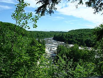
"Chutes des Ailes" in Saint-Narcisse
|
|
| Other name(s) | Rivière Batiscan |
| Country | Canada |
| Province | Quebec |
| Region | Capitale-Nationale |
| Regional County Municipality | Portneuf and Mékinac |
| Unorganized territory and a municipality | Lac-Jacques-Cartier and Stoneham-et-Tewkesbury |
| Physical characteristics | |
| Main source | Édouard Lake Lac-Édouard, Quebec 363 m (1,191 ft) 47°38′46″N 72°17′50″W / 47.6461°N 72.2972°W |
| River mouth | Saint Lawrence River Saint Lawrence River at Batiscan 5 km (3.1 mi) 46°31′13″N 72°14′15″W / 46.5202°N 72.2374°W |
| Length | 196 km (122 mi) |
| Basin features | |
| Basin size | 4,690 km2 (1,810 sq mi) |
| Tributaries |
|
The Batiscan River is a long river in Quebec, Canada. It flows for 196 kilometers (about 122 miles). The river starts at Lake Édouard (Quebec) and travels south and west. It finally empties into the Saint Lawrence River near the town of Batiscan, Quebec. This area is northeast of Trois-Rivières.
The Batiscan River flows through several areas. These include La Tuque, Portneuf, Mékinac, and Les Chenaux. From its start to the Saint-Adelphe, Quebec railway bridge, the land is mostly covered by forests. After that, it flows through mostly farmland.
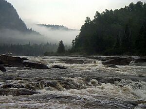
The valley of the Batiscan River is known as "Batiscanie". It's a great place for outdoor fun! You can go camping, enjoy nature, or try water sports. Popular activities include canoeing, kayaking, and rafting. The Batiscan River is famous for its exciting whitewater rapids. These rapids are perfect for experienced kayakers.
What's in a Name?
The Batiscan River got its name in 1602 from Samuel de Champlain. He said it was named after an Algonquin chief. But the name "Batiscan" was used by Native Americans even before the French arrived.
The meaning of "Batiscan" has different ideas. Some say it means "steam cloud" or "light." Others believe it means "spray of dried meat." One idea is "who rushes to his mouth," which might describe the river's flow. Another thought is that it comes from an Atikamekw word meaning "hoof." Or it could be from the cry "patiskam," meaning "stumble."
River's Journey
Where the River Starts
The Batiscan River begins high up in the Laurentian Mountains. It starts at 363 meters (about 1,191 feet) above sea level. Its source is Lake Édouard (Quebec), located in Lac-Édouard, Quebec. Another river, the Jeannotte River, also starts from Lake Édouard. The Jeannotte River later joins the Batiscan River.
After leaving Lake Édouard, the Batiscan River flows through several smaller lakes. One important lake it passes through is "Lake of the Cross." Another area that feeds the river is "Cookies Lake." This northern area is like a second starting point for the river.
Flowing Downstream
The Batiscan River flows through wild areas first. These include the Zec Jeannotte and Laurentides Wildlife Reserve. Then it enters the Portneuf Wildlife Reserve. As it continues, the river passes by several towns. These include Rivière-à-Pierre, Notre-Dame-de-Montauban, Quebec, Lac-aux-Sables, and Sainte-Thècle, Quebec. It also goes through Saint-Adelphe, Quebec, Saint-Stanislas, Saint-Narcisse, Quebec, Sainte-Geneviève-de-Batiscan, Quebec, and Batiscan, Quebec. The river mostly flows south for its 196 km journey.
The upper part of the river is mostly surrounded by forests. But as it gets closer to the Saint-Adelphe railway bridge, you start to see more farms. The lower part of the river is mainly agricultural land.
River's Waterfalls and Rapids
The Batiscan River has many exciting waterfalls and rapids. These are grouped into three main sections.
Upper Batiscanie Falls
This section starts where the Rivière-à-Pierre joins the Batiscan River.
- There are many Class II rapids for about 50 kilometers. These are from Pearles Lake down to the Island of the cross (Quebec). This part is great for canoe-camping.
- You'll find Class III and IV rapids, perfect for rafting. This section is called "Portes de l'enfer" (Gates of Hell).
- More rapids are in the Portneuf Wildlife Reserve. These include Trois-Roches (Three Rocks) Rapids and Savage Rapid.
Mid Batiscanie Falls
This part is between Murphy Falls in Saint-Stanislas and the mouth of the Rivière-à-Pierre.
- Some falls here are named by numbers, like Fall of the Ten and Fall of the Nine.
- The Fall of the Eight is near Lac-aux-Sables.
- Other falls include Fall in the Seven, Fall of the Six, and Fall of the Five.
- You'll also find Manitou fall and Falls to Jimmy.
- The famous Falls to Murphy are in Saint-Stanislas.
Lower Batiscanie Falls
This section is from the mouth of the Batiscan River up to the Falls to Murphy.
- Here are the Fall des Ailes (Fall of the Wings) and Ilets fall.
- The "Grande chute" (Great Fall) is 15 meters (about 49 feet) high. It's in Saint-Narcisse, Quebec and Sainte-Geneviève-de-Batiscan, Quebec. The Saint-Narcisse dam is built here.
- The "chutes de la Cheminée" (Falls of the chimney) are also 15 meters high. They are in Sainte-Geneviève-de-Batiscan.
In 1657, a group of French and Algonquin people traveled the river. They reported crossing 28 "jumps" or rapids on the Batiscan River. A big earthquake in 1663 changed the land. It might have made some waterfalls disappear and created new rocks.
River's Water System
The Batiscan River's watershed covers a huge area of 4,690 square kilometers (about 1,811 square miles). The amount of water flowing in the river changes a lot with the seasons. It's highest in May and lowest in September.
The watershed has about a hundred rivers. The main rivers that flow into the Batiscan River are:
- Castor noir
- Lightning river
- Jeannotte
- Miguick
- Rivière-à-Pierre
- Tawachiche
- Rivière-des-Envies
There are also about a thousand lakes in the basin. The biggest ones are Lake Édouard (Quebec) (25.2 km²), Batiscan (9.7 km²), and Lac-aux-Sables (5.31 km²). Over 85 dams have been built in the area.
River's Past
In 1639, the Jesuits bought land along the Batiscan River. They wanted to teach the Attikameks people. They used the river for fur trading for a long time. Later, in 1685, the Jesuits allowed settlers to build homes. These settlers mainly lived in Sainte-Geneviève-de-Batiscan.
Forest Industry
Starting in 1852, the Price Brothers and Company began cutting down trees. Many sawmills were built along the Batiscan River. Logs were floated down the river to the mills. The first trees cut were White Pine, sent to Great Britain. After the 1930s, the wood was used more for making paper. Floating logs down the river stopped in 1963.
Saint-Narcisse Electric Plant
In 1896, Jean-Baptiste Frégault bought rights to use the "Great Waterfall" near Saint-Narcisse, Quebec. He built a hydroelectric plant there. This plant created electricity and sent it through a 29 km (18 miles) power line. This was the first such line in the British Empire. The plant was later expanded and sold. In 1963, Hydro-Quebec took it over. Today, the central Saint-Narcisse plant can produce 15 megawatts of power. The Saint-Narcisse dam is 254 meters (833 feet) long and 21 meters (69 feet) high.
Old Mines and Forges
Iron was mined in the area from the 1700s to the early 1900s. Two ironworks, called "Forges de Batiscan" and "Forges de Saint-Tite," operated here. Zinc and lead were mined in Notre-Dame-de-Montauban, Quebec in the 1900s. Copper and nickel were mined near Lac-Édouard, Quebec in the 1970s.
Bridges Over the Batiscan
Many bridges cross the Batiscan River.
- Near the mouth, there's the Highway 138 bridge and a railway bridge in Batiscan.
- Further upstream, Highway 40 crosses the river in Sainte-Geneviève-de-Batiscan.
- The Sainte-Geneviève-de-Batiscan village bridge was first built in 1870. It has been rebuilt several times due to floods.
- There are pedestrian bridges and the Saint-Narcisse electric dam, which also acts as a bridge.
- In Mid Batiscanie, you'll find bridges in Saint-Stanislas and Saint-Adelphe, Quebec. An old covered wooden bridge in Saint-Adelphe was replaced in 1965.
- There are also railway bridges, like the one in Saint-Adelphe built in 1907.
- Bridges in Lac-aux-Sables and Notre-Dame-de-Montauban connect villages.
- In Upper Batiscanie, bridges like the Talbot Road bridge help access the Portneuf Wildlife Reserve.
- Near Lake of the Cross and Lake Édouard, there are more road and railway bridges.
- An old lock and bridge at the start of the river in Lake Édouard helped transport wood. It was built in 1897 but was destroyed by a flood in 1928.
In total, 19 road bridges and 7 railway bridges cross the Batiscan River.
Power Plants
The central Saint-Narcisse is the only hydroelectric power plant on the Batiscan River itself. However, two other power plants were built on rivers that flow into the Batiscan:
- The "Electric Kabibouska" plant was on the Rivière des Envies. It powered the villages of Saint-Séverin and Saint-Tite.
- A plant on the Rivière-à-Pierre powered the town of Rivière-à-Pierre.
Fun Places to Visit
Waterfall of the Nine
The Waterfall of the Nine is also called the "Waterfall of the five dollars bill." It's located near the village of Notre-Dame-de-Montauban. You can get a great view from the waterfront park. This park is called "Park of the Waterfall." The waterfall looks a lot like the image on an old Canadian five-dollar bill. The park has trails and an elevated walkway. This walkway lets visitors go onto a small island in the middle of the rapids. The park started being built in 1977.
Batiscan Park (Saint-Narcisse)
The regional Batiscan River Park covers a large area of 400 hectares (about 1,000 acres). It features waterfalls, rapids, and pools near the Saint-Narcisse dam. The park has a long elevated walkway that crosses the river. There are also many viewpoints and 25 kilometers (about 15.5 miles) of trails. These trails connect three towns: Saint-Stanislas, Saint-Narcisse, and Sainte-Geneviève-de-Batiscan. The park offers fun activities about nature, outdoor adventures, and history.
 | Sharif Bey |
 | Hale Woodruff |
 | Richmond Barthé |
 | Purvis Young |


