Tawachiche River facts for kids
Quick facts for kids Tawachiche River |
|
|---|---|

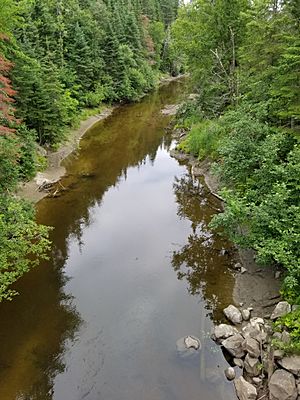
Tawachiche River, seen upstream from the road bridge of Saint-Alphonse Road (almost at the limit of Sainte-Thècle) and 0.5 km from the confluence of this river with the Batiscan River.
|
|
|
Location in Quebec
|
|
| Country | Canada |
| Province | Quebec |
| Region | Mauricie |
| Regional County Municipality | Mékinac Regional County Municipality |
| Municipality | Lac-aux-Sables and Sainte-Thècle |
| Physical characteristics | |
| Main source | Lac à l'Orignal (Moose lake) 379 m (1,243 ft) 47°01′30″N 72°28′30″W / 47.0251°N 72.4749°W |
| River mouth | Batiscan River Lac-aux-Sables, Quebec 109 m (358 ft) 46°49′39″N 72°26′09″W / 46.8275°N 72.4357°W |
| Length | 25 km (16 mi) |
| Basin features | |
| Basin size | 196 km2 (76 sq mi) |
| Tributaries |
|
The Tawachiche River flows from north to south for 25 kilometers. It is located entirely within the area of Lac-aux-Sables. This river is part of the Mékinac Regional County Municipality in Mauricie, Quebec, Canada.
Contents
Exploring the Tawachiche River's Path
The Tawachiche River's drainage area covers 196 square kilometers. This makes it the ninth largest sub-watershed in the Batiscanie region. The river flows through the village of Hervey-Jonction. It then crosses Rang Saint-Charles before joining the Batiscan River. This meeting point is near the border of Sainte-Thècle and Lac-aux-Sables.
The main branch of the Tawachiche River is the Tawachiche West River. It flows into the Tawachiche River about 13 kilometers from its mouth. This happens in the Audy area, close to the Zec Tawachiche boundary.
Where the River Begins: Upper Lakes
The Tawachiche River starts at "Lac à l'Orignal" (Moose Lake). This lake sits at an elevation of 379 meters. A small creek feeds Moose Lake from the north. This creek starts at an unnamed, heart-shaped lake.
From Moose Lake, the Tawachiche River flows south. It passes through several other lakes. These include Price Lake, "Petit lac Begin" (Small Begin Lake), Bégin Lake, Germain Lake, "Lac Profond" (Deep Lake), and Terrien Lake. Terrien Lake is the biggest body of water in this part of the river system. After Terrien Lake, the river flows southwest.
Further downstream, the river also gets water from lakes like "du Milieu" (Middle Lake), Boiteau, and Buffon. Fontaine Lake also feeds into the Tawachiche River.
The Tawachiche West River gets its water from lakes like Masketsi, Little Masketsi, and Roberge. These lakes are in the unorganized territory of Lac-Masketsi. Most of the river's starting points are within the Zec Tawachiche area. Lake Masketsi, covering 4.0 square kilometers, is the largest lake in this sub-watershed.
The River's Lower Sections
The lower part of the Tawachiche River watershed includes parts of Rang St-Georges and Rang St-Thomas in Sainte-Thècle.
Most of the river flows through forested areas. Even when it passes through farming areas near Hervey-Jonction, there's a strip of trees along each bank. These wooded strips are usually 50 to 100 meters wide.
Northeast of Hervey-Jonction, after passing under the Route 153 bridge, the river flows over beautiful waterfalls. These falls become very strong in March and April due to melting snow. The Tawachiche River usually freezes from November to April. In the past, this allowed people to build ice roads for transporting timber to lumber camps. These ice roads were important for Indigenous people and early settlers.
Connecting Communities: Roads and Railways
From Hervey-Jonction, the "Lac-en-Coeur" road leads north to the lake of the same name. This lake is only 2.0 kilometers from Hervey-Jonction. The road then turns right and becomes the Tawachiche road. This road crosses the railway line that connects Hervey-Jonction to La Tuque. Soon after crossing the railway, the road crosses the Tawachiche River itself. Both the railway and the Tawachiche road generally follow the river's path north.
In the Audy area, near where the Tawachiche West River joins, the railway turns northwest. It then runs parallel to the Tawachiche West River. The railway stays on the right bank of both the Tawachiche West and Tawachiche rivers. Further north, the railway goes around "petit lac Masketsi" and then along lake Masketsi.
Many cottages are built along the Tawachiche River. You can find them in the Audy area, near the waterfalls in Hervey-Jonction, and between the village and the river's mouth. The Audy area offers services like lodging, cabin rentals, and camping for visitors.
Bridges Over the Tawachiche River
Many bridges cross the Tawachiche River. Here are some of the main ones, starting from the river's mouth:
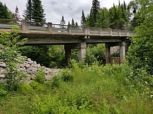
- A bridge connects the St-Thomas North road and Saint-Alphonse road. It is about 0.5 kilometers upstream from where the Tawachiche River meets the Batiscan River.
- The road bridge on Quebec Route 153 (chemin Saint-Charles) is at the north end of Hervey-Jonction. It is located upstream from a large drop in the river.
- The railway bridge of the Canadian National Railway crosses the river 0.4 kilometers upstream from the Route 153 bridge.
- A pedestrian bridge was once located near the second Veillette & Frères Ltée sawmill, north of Hervey-Jonction.
- The first Tawachiche road bridge leads to the Audy sector, which is a popular spot for visitors.
- A second Tawachiche Road bridge is further upstream, also leading towards the Audy sector.
- A third Tawachiche road bridge in Audy crosses the Tawachiche West River, the main branch of the Tawachiche.
- A fourth road bridge, Tawachiche Road East, is near Lake Pollack.
Dams and River Management
Dams were built on the Tawachiche River and its branches, like the Tawachiche West and East rivers. Starting in 1933, these dams helped control the river's flow and water level. This was important for transporting timber by floating logs downstream. Since the 1950s, these dams have also helped with water activities like boating and fishing.
Some of the main dams include:
- Calau Dam
- Suève-1 and Suève-2 Dams
- Petit-Lac-Masketsi Dam, which belongs to the Quebec government.
- Lac Masketsi Dam, built in 1933 to help regulate water for sawmills. It is now also owned by the Quebec government.
Sawmills and Logging History
The Tawachiche River area has a history of logging and sawmills. An early sawmill, owned by Théotime Massicotte, was located near the Audy railway station. This mill was later sold to Frank Blais and then to "Veillet & Frères Ltée" (Veillet & Brothers Ltd) in 1922.
The Veillet & Brothers company was founded in 1920 by four brothers from Sainte-Thècle. They bought the rights to cut hardwood in the Tawachiche River area, north of Hervey-Jonction. This sawmill employed many people for sawing wood, moving logs, stacking, and transport. It also supported many woodcutters in the forest. The mill operated until about 1934.
A second, newer sawmill was built by Veillette & Frères Ltée in the fall of 1933. This one was located on the right bank of the Tawachiche River, 500 meters north of Hervey-Jonction. It started working in the spring of 1934, replacing the older Audy mill. This new mill also relied on dams to control water flow for floating logs. Logs were cut into smaller pieces and then loaded onto railway cars. The sawmill stopped operating in 1941 because wood started being transported by truck directly to paper mills. The sawmill was taken down in 1946.
Fun Things to Do: Main Attractions
The Tawachiche River area offers many attractions for nature lovers and adventurers:
Discover the Zec Tawachiche
The Zec Tawachiche is a large outdoor recreation area. It covers 318 square kilometers and has 128 lakes, with 72 of them open for fishing. There are also four rivers. The ZEC offers many activities you can reach by car. These include hunting, fishing, rustic camping, canoe camping, and staying in cabins. You can also enjoy hiking trails. Depending on the season, you can ride ATVs or snowmobiles. It's a great place to observe nature, plants, animals, and beautiful landscapes.
The main entrance to the ZEC is near where the Tawachiche West River joins the Tawachiche River. This is in the Audy station sector, about 9.1 kilometers from the Route 153 intersection in Hervey-Jonction. You can also enter the ZEC from the north, via Quebec Route 155. Seaplanes can even land on lakes like Masketsi, Roberge, "à l'Ours" (Bear Lake), and Hackett.
Rock Climbing at Tawachiche Cliff
The Tawachiche cliff climbing site is on the western shore of Lake Terrien. Since 2009, rock climbing fans have visited this granite cliff. It overlooks a bog and Lake Terrien. In many places, the cliff rises over 50 meters vertically, with some sections reaching about 100 meters. You need a boat to get to the bottom of the cliff. Because it faces south and southeast, you can climb here from March to November. The cliff has five sections named after a Native American legend: Tomahawk, Indian Summer, Attimakekw, Wometaci, and Maskwaaskwaaskwa. Lake Terrien is about a 15-minute drive from the Zec Tawachiche entrance.
Holiday Camp in Lac-en-Coeur
The Holiday Camp in Lac-en-Coeur has been operating since 1946. It offers fun stays with educational activities for young people. This camp is located 2.2 kilometers north of the village of Hervey-Jonction. The "The Villages Students inc." corporation manages the camp.
 | Georgia Louise Harris Brown |
 | Julian Abele |
 | Norma Merrick Sklarek |
 | William Sidney Pittman |


