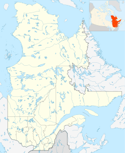
Lake Roberge (Lac-Masketsi) facts for kids
Quick facts for kids Lake Roberge |
|
|---|---|
| Location | Mékinac Regional County Municipality, Mauricie, Quebec |
| Coordinates | 46°59′37″N 72°31′51″W / 46.99361°N 72.53083°W |
| Lake type | Natural |
| Basin countries | Canada |
| Max. length | 2.25 km (1.40 mi) |
| Max. width | 1.25 km (0.78 mi) |
Lake Roberge is a beautiful lake found in the Mauricie region of Quebec, Canada. It's located in a wild, unorganized area called Lac-Masketsi, Quebec, within the Mékinac Regional County Municipality. This lake is completely surrounded by forests. During the colder months, from November to April, the surface of Lake Roberge usually freezes over, making it a winter wonderland.
Contents
Exploring Lake Roberge's Geography
Lake Roberge stretches about 2.25 kilometers (1.4 miles) from north to south. At its widest point, it measures about 1.25 kilometers (0.78 miles) across. It's quite close to another important lake, Lake Masketsi, which lies to its west. A hilly strip of land, varying in width, separates these two lakes.
Water Sources for Lake Roberge
Just north of Lake Roberge, there are four smaller lakes. These lakes, including Lake Faber and Lake Narcisse, all drain their water into Lake Roberge. This means they act as important sources, feeding water into the main lake. Further north from these smaller lakes, you'll find a special dividing line. This line separates the areas where water flows into the Saint-Maurice River from where it flows into the Batiscan River.
Roads and Access
A road called Tawachiche Road West runs along the western side of Lake Roberge. This road helps people access the lake and the surrounding forest areas.
The Name of Lake Roberge
The name "Lake Roberge" was officially recognized and added to the Bank of Place Names by the Commission de toponymie du Québec (Quebec's Geographical Names Board) on December 5, 1968. This means its name is now a permanent part of Quebec's geography.
 | Shirley Ann Jackson |
 | Garett Morgan |
 | J. Ernest Wilkins Jr. |
 | Elijah McCoy |


