Lake Roberge (Grandes-Piles) facts for kids
Quick facts for kids Lake Roberge |
|
|---|---|

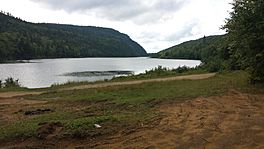
South part of Lake Roberge (Grandes-Piles, Quebec) located in a narrow valley.
|
|
| Location | Grandes-Piles, Mauricie |
| Coordinates | 46°45′58″N 72°40′30″W / 46.76611°N 72.67500°W |
| Lake type | Natural |
| Primary outflows | North Mékinac River |
| Basin countries | Canada |
| Max. length | 3.4 km (2.1 mi) |
| Max. width | 0.2 km (0.12 mi) |
Lake Roberge is a beautiful natural lake located in the town of Grandes-Piles, in the Mauricie region of Quebec, Canada. It's part of the Mekinac Regional County Municipality. This lake is known for its long, narrow shape, stretching out between mountains.
Contents
Exploring Lake Roberge's Geography
Lake Roberge in Grandes-Piles is very long and thin, like a ribbon! It stretches for about 3.4 kilometers (2.1 miles) from northwest to southeast. At its widest point, it's only about 200 meters (656 feet) across. The lake is divided into four parts, with the southern part being the largest.
This lake sits in a valley, surrounded by mountains in the Grandes-Piles area. It's very close to the border of another town called Saint-Roch-de-Mékinac.
Rivers and Water Flow
The water from Lake Roberge flows out through the North Mékinac River. This river travels southeast for about 6.1 kilometers (3.8 miles) through a forest. It eventually flows into the Rivière des Envies in the town of Saint-Tite.
Roads and Nearby Lakes
A part of Route 159 runs along the entire southeastern side of Lake Roberge. This road is important for traveling between the Saint-Maurice River area and the Rivière des Envies in Saint-Tite.
About one kilometer (0.6 miles) northwest of Lake Roberge (Grandes-Piles), in the same valley, you'll find the "Second Roberge Lake." This second lake is part of the water system that flows into the Saint-Maurice River.
The "Fountain Lake Road" connects to Route 159 between these two lakes. This road goes northeast and links up with the "Joseph Saint-Amant road" in Sainte-Thècle. The "Fountain Lake Road" also provides access to several other lakes in Grandes-Piles, including Lake Équerre, Fountain Lake, Little Lake Dorval, Lake Nicolas, and Lac à Pierre.
Another road, the "chemin du lac des îles" (Island Lake Road), connects to Route 159 near the Fountain Lake Road intersection. It heads south to serve Lake Clair, the "Lake of the Isles," and a few other small lakes. There's also the "path of Clear Lake," which serves the eastern part of Lake Clair.
A Look at History
In the past, the "Fountain Lake Road" and "Joseph Saint-Amant road" were very important. They were used for cutting down trees and transporting timber. These roads also played a big role in tourism and outdoor activities like hunting and fishing in the area.
What's in a Name?
The study of place names is called "toponymy." The Commission de toponymie du Québec (Quebec's Geographical Names Board) has recorded 17 different places named "Lake Roberge" across Quebec!
Most of these names come from people with the last name Roberge. So, Lake Roberge (Grandes-Piles) was likely named after someone from the Roberge family. The name "Lake Roberge" for this specific lake was officially registered on December 5, 1968.
 | May Edward Chinn |
 | Rebecca Cole |
 | Alexa Canady |
 | Dorothy Lavinia Brown |


