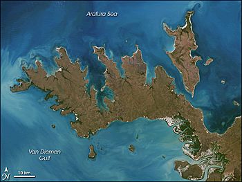
Croker Island facts for kids
|
Native name:
Margo
|
|
|---|---|

Image of Croker Island
with Cobourg Peninsula |
|
|
Croker Island (Northern Territory, Australia)
|
|
| Geography | |
| Location | Arafura Sea |
| Coordinates | 11°08′S 132°33′E / 11.133°S 132.550°E |
| Major islands | Croker, Darch, Templer |
| Area | 331.5 km2 (128.0 sq mi) |
| Length | 43 km (26.7 mi) |
| Width | 15 km (9.3 mi) |
| Highest elevation | 15 m (49 ft) |
| Administration | |
|
Australia
|
|
| Territory | Northern Territory |
| Shire | West Arnhem Region |
| Ward | Barrah Ward |
| Largest settlement | Minjilang (pop. 271) |
| Demographics | |
| Population | 300 |
| Pop. density | 0.9 /km2 (2.3 /sq mi) |
| Ethnic groups | Yarmirr |
Croker Island is an island located in the Arafura Sea, off the coast of the Northern Territory, Australia. It is about 200 kilometers (124 miles) northeast of Darwin.
The island is separated from the Cobourg Peninsula in the west by a narrow stretch of water called Bowen Strait. To the north and east is the Arafura Sea, and to the south and southeast is Mountnorris Bay. Croker Island is about 43 kilometers (27 miles) long and up to 15 kilometers (9 miles) wide. It covers an area of 331.5 square kilometers (128 square miles). The highest point on the island is only 15 meters (50 feet) above sea level. Croker Island is the largest and only island in the Croker Group that is always lived on.
Contents
Living on Croker Island
When Europeans first arrived, the local people of Croker Island were the Jaako, who spoke a unique language called Marrgu. Today, the local communities mainly speak Iwaidja and Mawng.
The main community on Croker Island is an Aboriginal village called Minjilang. It is located on Mission Bay on the east coast. Besides Minjilang, there are also nine smaller family outstations (small communities). The largest of these is Inngirnatj (Point David) at the southern end of the island.
Here are some of the settlements from north to south:
- Alamirra (near Somerville Bay)
- Timor Springs (north of Minjilang)
- Wanakutja (on Palm Bay in the northwest)
- Minjilang (Mission Bay), the main village
- Adjamarrago (north of Croker Island Aerodrome)
- Keith William's Outstation (Arrgamumu, Arrgamurrmur) (southeast of Mission Bay)
- Walka (Barge Landing) (south side of Mission Bay, with a pier for barges)
- Sandy Bay (near Sandy Bay on the east coast)
- Marramarrani (southwest coast)
- Inngirnatj (Point David) (southern end, west side, with a boat pier)
From 1940 to 1968, the Methodist Overseas Mission ran the Croker Island Mission in Minjilang.
A Journey During World War II
During World War II, Japanese planes bombed Darwin in February 1942. Because of this, non-Indigenous children were moved away from the island. To keep them safe, a missionary named Margaret Somerville led 95 Indigenous children from the island's orphanage on a long journey.
They traveled across the Australian mainland, taking a train through central Australia, and finally arrived in Sydney, New South Wales. This amazing trip covered about 5,000 kilometers (3,100 miles) and took over 44 days! The children returned to Croker Island in 1946.
This journey was written about in Margaret Somerville's book They Crossed a Continent. It was also featured in an ABC documentary called Croker Island Exodus. This period is also part of a difficult time in history known as the Stolen Generations.
Land and Sea Rights
The traditional custodians of Croker Island, the Yarmirr people, made a claim over the sea around the island. This case, called Yarmirr v Northern Territory, was decided by the High Court of Australia on October 11, 2001.
The court decided that the Yarmirr people do have native title (special rights) over the sea and seabed. However, everyone still has common law rights to fish and travel by boat. This means that the native title over the sea is "non-exclusive," allowing others to use the sea as well.
Island Environment
Croker Island was badly damaged by Cyclone Ingrid in March 2005. In 2015, a program was carried out to remove wild horses from the island.
 | Emma Amos |
 | Edward Mitchell Bannister |
 | Larry D. Alexander |
 | Ernie Barnes |


