Crow Creek (Alaska) facts for kids
Crow Creek is a stream in the Chugach Mountains of Alaska, USA. It is the only important branch of Glacier Creek, which flows into Turnagain Arm. Crow Creek is well-known because people have been mining for gold there since the late 1800s.
Contents
Crow Creek's Location and Flow
Crow Creek is a branch of Glacier Creek, joining it about 5 miles (8 km) before Glacier Creek reaches Turnagain Arm. The tall, rugged mountains at the top of Crow Creek separate the water that flows to Turnagain Arm from the water that goes to Knik Arm.
At the head of Crow Creek, there's a place called Crow Creek Pass, which is about 3,400 feet (1,036 m) high. This pass offers a good path from Crow Creek to Raven Creek, which flows into Eagle River. From its start in the pass to its end, Crow Creek is about 5 miles (8 km) long.
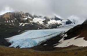
Near its beginning, the stream drops very steeply, falling over 1,000 feet (305 m) in just 1 mile (1.6 km) through waterfalls and fast-moving water. Several small glaciers feed Crow Creek, making its water cloudy during the summer. Below the pass, the stream leaves its narrow, rock-cut valley and enters a wide, gravel-filled area.
The lower part of this gravel area is blocked by a pile of rocks and dirt left by a glacier, called a terminal moraine. This moraine caused the gravel to build up behind it. The stream then flows quickly over the moraine through a rocky path. After that, it enters a narrow valley filled with gravel, with flat, bench-like areas on the sides. Closer to its end, Crow Creek flows into a deep, narrow canyon with almost straight-up walls.
Rocks and Land in the Crow Creek Area
The main rocks in the Crow Creek area are mostly layers of argillites (a type of hard shale) and graywackes (a kind of sandstone). There are also some conglomerates (rocks made of pebbles and gravel). Many granitic dikes and sills (flat sheets of igneous rock) cut through these layers.
In some places, the shale rocks have changed due to heat and pressure, a process called metamorphism. This has created slaty cleavage (where rocks split into thin, flat layers) and sometimes even a schistose structure (where rocks have a layered, flaky texture). The rock layers in this area generally run from northeast to southwest. Near the mouth of Crow Creek, they usually tilt steeply to the southeast. However, at the top of the valley, the layers are folded, and their direction changes more towards the east.
How Crow Creek Was Formed
The way Crow Creek's landscape formed is quite complex. However, the deep holes dug during gold mining have given us a lot of important clues about its past.
After a long period when much of the region was covered by thick ice (intense glaciation), the glaciers in Crow Creek and Glacier Creek began to melt and shrink. The Crow Creek glacier melted faster because it had less ice. This allowed the water from Crow Creek to flow out and carve a deep channel into the solid rock.
Later, the Glacier Creek glacier moved forward again, and the Crow Creek glacier might have moved a little too. This blocked Crow Creek's waters, causing the stream to drop its load of sediment. This filled the old channel and part of the valley with water-laid sediments (fluvioglacial deposits). When the glaciers finally melted back to their current smaller sizes, Crow Creek cut a new path through these deposits. This new path is slightly different from the old one, which is why the old channel can be seen in some places where the paths cross.
Gold Mining at Crow Creek
|
Crow Creek Consolidated Gold Mining Company
|
|

The Crow Creek Mine is located at mile 0.3 of Crow Creek Road, which turns off the Alyeska Highway at mile 0.3. It produced up to 700 oz. of gold per month.
|
|
| Nearest city | Girdwood, Alaska |
|---|---|
| Area | 4 acres (1.6 ha) |
| Built | 1898 |
| NRHP reference No. | 78000517 |
Quick facts for kids Significant dates |
|
| Added to NRHP | September 13, 1978 |
The first claims, or legal rights to mine, on Crow Creek were made in 1897. These were near the mouth of the stream, where gold is still being mined today. Before 1903, most of the mining was done by hand, using picks and shovels, on the gravels that were easiest to reach. This included an area called Eagan bar, the current rock canyon, and some surface gravels above the canyon.
In 1903 and 1904, miners started using hydraulic methods. This means using powerful jets of water to wash away gravel and expose the gold. However, it was hard to reach the solid rock (bedrock) above the rock canyon. By 1904, a group of eight partners, known as the "Crow Creek boys," were mining near the rock canyon. Late in 1904, they found an old, deeply buried rock channel northeast of the current canyon.
From 1905 to 1914, several companies worked to remove the gravels in and above this old channel. Their goal was to create a bedrock drain, a channel that would allow water to flow away from the gravel basin above the current canyon. The Crow Creek Consolidated Mining Co. was formed and operated until 1906. In 1907, the property was sold to the Nutter-Dawson Co., which then became the Alaska Crow Creek Mining Co. in 1914.
The Alaska Crow Creek Mining Company used hydraulic mining. They had about 30 claims along several miles of the creek bed. The company spent a lot of effort getting the property ready for good mining. By the fall of 1915, they had finished the main work. They washed away the gravels at the lower end of the creek, which had little gold, down to the bedrock. They then built a flume, a long channel, to carry the stream around this point.
This bedrock flume was 2,200 feet (671 m) long, 5 feet (1.5 m) wide, and 5 feet (1.5 m) deep. It was built with a slight slope. At the start of the flume, the bottom was lined with strong manganese steel plates. The next seven sections had railroad iron for riffles (grooves that catch gold). After that, 14-inch (36 cm) wooden blocks were used.
A ditch about 1 mile (1.6 km) long brought water from the upper part of Crow Creek to a penstock (a pipe that delivers water under pressure). This created a drop of 300 to 400 feet (91 to 122 m) at the bottom of the mining pit. The main pipe was 2 feet (0.6 m) wide. Several "giants" (large nozzles that shoot water) were used, depending on how much water was available. The property also had a sawmill to provide wood for the flume and buildings. The 16 claims later included in this property stretched from Glacier Creek up Crow Creek.
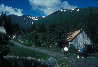
The Crow Creek Mine is still active today. The area is also open to the public as a place to visit. It has historic buildings from the early days of mining, which are listed on the National Register of Historic Places.
 | Audre Lorde |
 | John Berry Meachum |
 | Ferdinand Lee Barnett |


