Cuilapa facts for kids
Quick facts for kids
Cuilapa
|
|
|---|---|

Cuilapa-Barbarena volcanic field
|
|
| Country | |
| Department | |
| Area | |
| • Total | 72 sq mi (187 km2) |
| Population
(2018 census)
|
|
| • Total | 41,359 |
| • Density | 572.8/sq mi (221.2/km2) |
| Climate | Aw |
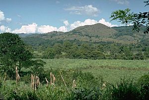
Cuilapa, also known as Santa Rosa Cuilapa, is a lively town in Guatemala. In 2018, about 41,359 people lived here. It's the main city, or capital, of the department of Santa Rosa. Cuilapa is also special because it marks the geographic center of the Americas!
Contents
Discovering Cuilapa
A Look at History
Cuilapa has an interesting past. One important event was a big earthquake.
The 1913 Earthquake
On March 8, 1913, a strong earthquake shook the Santa Rosa area. It had a magnitude of 6.4. The earthquake caused a lot of damage in Cuilapa. Many homes were affected. Buildings like the cathedral were also damaged. Other nearby towns felt the earthquake too. These included Barberena and Pueblo Nuevo Viñas. Landslides happened in some areas. Roads were blocked by the falling earth.
What's the Weather Like?
Cuilapa has a tropical savanna climate. This means it's usually warm all year. There are wet and dry seasons.
| Climate data for Amatitlán | |||||||||||||
|---|---|---|---|---|---|---|---|---|---|---|---|---|---|
| Month | Jan | Feb | Mar | Apr | May | Jun | Jul | Aug | Sep | Oct | Nov | Dec | Year |
| Mean daily maximum °C (°F) | 28.4 (83.1) |
28.8 (83.8) |
29.8 (85.6) |
29.7 (85.5) |
29.3 (84.7) |
28.2 (82.8) |
29.0 (84.2) |
28.7 (83.7) |
28.0 (82.4) |
28.0 (82.4) |
27.9 (82.2) |
27.8 (82.0) |
28.6 (83.5) |
| Daily mean °C (°F) | 22.7 (72.9) |
22.9 (73.2) |
23.9 (75.0) |
24.3 (75.7) |
24.4 (75.9) |
23.9 (75.0) |
24.3 (75.7) |
24.1 (75.4) |
23.7 (74.7) |
23.3 (73.9) |
22.9 (73.2) |
22.5 (72.5) |
23.6 (74.4) |
| Mean daily minimum °C (°F) | 17.0 (62.6) |
17.1 (62.8) |
18.0 (64.4) |
19.0 (66.2) |
19.5 (67.1) |
19.6 (67.3) |
19.6 (67.3) |
19.5 (67.1) |
19.4 (66.9) |
18.7 (65.7) |
17.9 (64.2) |
17.2 (63.0) |
18.5 (65.4) |
| Average rainfall mm (inches) | 2 (0.1) |
3 (0.1) |
11 (0.4) |
50 (2.0) |
226 (8.9) |
374 (14.7) |
302 (11.9) |
287 (11.3) |
353 (13.9) |
255 (10.0) |
61 (2.4) |
8 (0.3) |
1,932 (76) |
| Source: Climate-Data.org | |||||||||||||
Where is Cuilapa Located?
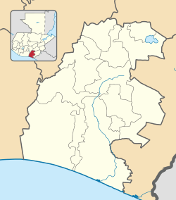
Cuilapa is in the Santa Rosa Department. It shares borders with several other towns. To the east, it also borders a town in the Jutiapa Department.
 |
Nueva Santa Rosa | Casillas |  |
|
| Barberena | Oratorio Jutiapa, Jutiapa Department municipality |
|||
| Pueblo Nuevo Viñas | Chiquimulilla and Santa María Ixhuatán |
See also
 In Spanish: Cuilapa para niños
 | Janet Taylor Pickett |
 | Synthia Saint James |
 | Howardena Pindell |
 | Faith Ringgold |


