Culgoa County facts for kids
Quick facts for kids CulgoaNew South Wales |
|||||||||||||||
|---|---|---|---|---|---|---|---|---|---|---|---|---|---|---|---|

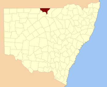
Location in New South Wales
|
|||||||||||||||
|
|||||||||||||||
Culgoa County is a special kind of area in New South Wales, Australia. It's one of 141 such areas called "cadastral divisions." Think of it like a big, old-fashioned map section used for keeping track of land. This county is bordered by two important rivers: the Warrego River on its west side and the Culgoa River on its east side. The name "Culgoa" itself has a mysterious origin; nobody knows exactly where it came from!
Contents
Discovering Culgoa County
Culgoa County is a large land area in the western part of New South Wales. It's a significant part of Australia's history of how land was divided and managed. These divisions helped people keep records of who owned what land.
Where is Culgoa County?
This county is located in a fascinating part of Australia. Its western edge follows the Warrego River, and its eastern side is marked by the Culgoa River. These rivers are important waterways in the region. Culgoa County also shares borders with Queensland to the north.
What is a Cadastral Division?
You might be wondering, "What exactly is a cadastral division?" It's a way of dividing land for official purposes. These divisions were created a long time ago to help with land ownership, mapping, and administration. They are like invisible boundaries on a map that help governments keep track of every piece of land.
Exploring the Parishes of Culgoa
Inside Culgoa County, there are many smaller areas called parishes. These parishes are even smaller divisions of land. Each parish has its own name and location. They are used for more detailed mapping and local administration. The table below lists many of these parishes, showing which local government area (LGA) they belong to and their approximate coordinates.
| Parish | LGA | Coordinates |
|---|---|---|
| Anderson | Bourke Shire | 29°00′38″S 145°54′22″E / 29.01056°S 145.90611°E |
| Barringun | Bourke Shire | 29°01′18″S 145°46′07″E / 29.02167°S 145.76861°E |
| Belalie | Bourke Shire | 29°06′31″S 145°49′52″E / 29.10861°S 145.83111°E |
| Beri | Brewarrina Shire | 29°01′00″S 147°09′38″E / 29.01667°S 147.16056°E |
| Boneda | Bourke Shire | 29°10′53″S 146°16′03″E / 29.18139°S 146.26750°E |
| Booroominia | Brewarrina Shire | 29°25′21″S 146°35′27″E / 29.42250°S 146.59083°E |
| Bourbah | Brewarrina Shire | 29°03′43″S 147°02′30″E / 29.06194°S 147.04167°E |
| Brenda | Brewarrina Shire | 29°01′02″S 147°18′14″E / 29.01722°S 147.30389°E |
| Brolga | Bourke Shire | 29°19′00″S 146°16′51″E / 29.31667°S 146.28083°E |
| Bundaleear | Brewarrina Shire | 29°04′05″S 146°24′26″E / 29.06806°S 146.40722°E |
| Buntawarrara | Bourke Shire | 29°25′09″S 146°08′23″E / 29.41917°S 146.13972°E |
| Cedia | Bourke Shire | 29°26′13″S 146°14′25″E / 29.43694°S 146.24028°E |
| Cockellireena | Bourke Shire | 29°39′07″S 146°34′18″E / 29.65194°S 146.57167°E |
| Coolibar | Bourke Shire | 29°25′04″S 146°27′25″E / 29.41778°S 146.45694°E |
| Corella | Bourke Shire | 29°28′19″S 146°20′37″E / 29.47194°S 146.34361°E |
| Coward | Bourke Shire | 29°30′28″S 146°13′35″E / 29.50778°S 146.22639°E |
| Currindule | Bourke Shire | 29°24′56″S 146°02′16″E / 29.41556°S 146.03778°E |
| Darling | Brewarrina Shire | unknown |
| Diemunga | Brewarrina Shire | 29°05′43″S 146°55′24″E / 29.09528°S 146.92333°E |
| Dingo | Bourke Shire | 29°01′18″S 146°07′57″E / 29.02167°S 146.13250°E |
| Emu Hill | Bourke Shire | 29°12′03″S 146°06′07″E / 29.20083°S 146.10194°E |
| Enngonia | Bourke Shire | 29°18′22″S 145°52′49″E / 29.30611°S 145.88028°E |
| Grindie | Bourke Shire | 29°33′44″S 146°20′23″E / 29.56222°S 146.33972°E |
| Gurrera | Bourke Shire | 29°16′13″S 146°19′45″E / 29.27028°S 146.32917°E |
| Hardie | Bourke Shire | 29°08′45″S 146°16′02″E / 29.14583°S 146.26722°E |
| Jamieson | Brewarrina Shire | 29°12′01″S 146°28′03″E / 29.20028°S 146.46750°E |
| Keats | Brewarrina Shire | 29°09′10″S 146°48′22″E / 29.15278°S 146.80611°E |
| Lissington | Bourke Shire | 29°26′27″S 146°20′21″E / 29.44083°S 146.33917°E |
| Loxton | Bourke Shire | 29°11′22″S 145°55′36″E / 29.18944°S 145.92667°E |
| Malgoolie | Bourke Shire | 29°34′32″S 146°27′44″E / 29.57556°S 146.46222°E |
| Milroy West | Brewarrina Shire | 29°30′57″S 146°33′11″E / 29.51583°S 146.55306°E |
| Morton Plains | Brewarrina Shire | 29°01′19″S 146°33′14″E / 29.02194°S 146.55389°E |
| Mudelooromun | Brewarrina Shire | 29°04′04″S 146°40′59″E / 29.06778°S 146.68306°E |
| Opal | Bourke Shire | 29°04′05″S 146°17′22″E / 29.06806°S 146.28944°E |
| Payera | Brewarrina Shire | 29°22′43″S 146°37′11″E / 29.37861°S 146.61972°E |
| Power | Bourke Shire | 29°16′25″S 146°02′47″E / 29.27361°S 146.04639°E |
| Tatala | Brewarrina Shire | 29°07′53″S 146°59′02″E / 29.13139°S 146.98389°E |
| Tawaggan | Brewarrina Shire | 29°01′47″S 146°48′44″E / 29.02972°S 146.81222°E |
| Thurlagoona | Bourke Shire | 29°03′35″S 145°56′17″E / 29.05972°S 145.93806°E |
| Thurmylae | Bourke Shire | 29°16′52″S 145°54′49″E / 29.28111°S 145.91361°E |
| Wee Warra | Bourke Shire | 29°22′30″S 145°57′54″E / 29.37500°S 145.96500°E |
| Weejallah | Bourke Shire | 29°16′20″S 146°09′48″E / 29.27222°S 146.16333°E |
| Weilmoringle | Brewarrina Shire | 29°13′14″S 146°54′00″E / 29.22056°S 146.90000°E |
| Yamby | Brewarrina Shire | 29°16′44″S 146°46′57″E / 29.27889°S 146.78250°E |
| Yamby West | Brewarrina Shire | 29°14′18″S 146°38′21″E / 29.23833°S 146.63917°E |
| Yarran | Brewarrina Shire | 29°17′46″S 146°29′10″E / 29.29611°S 146.48611°E |

