Cunit facts for kids
Quick facts for kids
Cunit
|
|||
|---|---|---|---|
|
Municipality
|
|||
 |
|||
|
|||
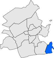
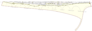
Location of Cunit within Baix Penedès, Catalonia.
|
|||
| Lua error in Module:Location_map at line 396: The value "1°38'26" W" provided for longitude is not valid. | |||
| Country | Spain | ||
| Area | |||
| • Total | 9.7 km2 (3.7 sq mi) | ||
| Elevation | 10 m (30 ft) | ||
| Population
(2018)
|
|||
| • Total | 12,326 | ||
| • Density | 1,271/km2 (3,291/sq mi) | ||
| Postal code |
43881
|
||
| Area code(s) | 977 | ||
Cunit (pronounced ku-NEET) is a town located on the coast of Catalonia, Spain. It is part of the Costa Daurada, also known as the Golden Coast. Cunit is in the Baix Penedès region, which is in the province of Tarragona. It sits on the northeast coast of Spain, right by the Mediterranean Sea.
Contents
Location and How to Get There
Cunit is in the Baix Penedès area of the province of Tarragona. Even though it's in Tarragona, it's considered part of the larger Urban Region of Barcelona. This means it's easy to reach from Barcelona.
The town shares borders with Segur de Calafell, which is in the same region. It also borders Cubelles and Castellet i la Gornal. Cunit has a train connection to Barcelona and other places further north. It's part of the Rodalies de Catalunya regional railway system.
History and Culture
Cunit has a very long history. People have lived here since prehistoric times. Archeologists have found items from as far back as 3700 BC!
First People in Cunit
Records show that the first people settled in Cunit in at least six different places. These early settlements were spread out. They were similar to other coastal towns in the Baix Penedès region. These towns often traded with merchants from other areas. This trading likely changed the way the early settlers lived.
Old Buildings and Art
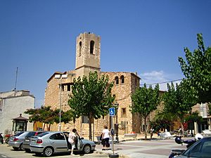
Cunit has some interesting old buildings and historical sites. You can learn more about the town's past by exploring its architectural heritage.
Population Changes
Around the year 1590, Cunit was almost empty. This was because of attacks by pirates. However, one farm, called Mas of Vilaseca, remained populated. There are also records from the 1600s about a fishing village on the beach. Fishermen were allowed to fish on Sundays and holidays if they gave a small part of their catch to the local church.
Starting in the 1960s, Cunit became a popular place for summer vacations. Many people from the BarcelonaMetropolitan Area came here. At the same time, it grew into a major residential area along the Golden Coast.
Weather in Cunit
Cunit has a Mediterranean climate. This means it has mild winters and hot summers.
| Climate data for Cunit | |||||||||||||
|---|---|---|---|---|---|---|---|---|---|---|---|---|---|
| Month | Jan | Feb | Mar | Apr | May | Jun | Jul | Aug | Sep | Oct | Nov | Dec | Year |
| Mean daily maximum °F (°C) | 62.8 (17.1) |
67.6 (19.8) |
72.1 (22.3) |
73.8 (23.2) |
81.0 (27.2) |
82.6 (28.1) |
89.2 (31.8) |
90.3 (32.4) |
84.7 (29.3) |
79.9 (26.6) |
73.8 (23.2) |
67.5 (19.7) |
77.1 (25.1) |
| Mean daily minimum °F (°C) | 35.1 (1.7) |
34.9 (1.6) |
37.2 (2.9) |
43.0 (6.1) |
53.2 (11.8) |
54.0 (12.2) |
65.5 (18.6) |
63.3 (17.4) |
56.5 (13.6) |
55.6 (13.1) |
45.7 (7.6) |
36.9 (2.7) |
48.4 (9.1) |
| Average precipitation inches (mm) | 5.25 (133.4) |
0.18 (4.6) |
0.26 (6.6) |
0.25 (6.4) |
0.68 (17.2) |
0.08 (2.0) |
0.06 (1.4) |
1.22 (31.0) |
3.87 (98.4) |
1.48 (37.6) |
0.24 (6.0) |
1.27 (32.2) |
14.84 (376.8) |
| Source: Darrera | |||||||||||||
Natural Environment
Beautiful Beaches
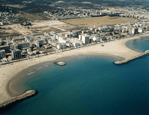
One of the best things about Cunit is its beaches. It has two and a half kilometers of golden sandy beaches. These beaches are protected by special structures called breakwaters. There are seven long breakwaters and four shaped like islands.
These breakwaters were built in the early 1980s. They were needed because building a reservoir and ports nearby caused the beaches to lose sand. Since 1997, Cunit's beaches have received the Blue Flag award. This award is given by the European Foundation for Environmental Education for clean and well-managed beaches.
Managing the Coastline
Cunit's coast has important environmental structures. These include a power plant and a desalination plant (which turns seawater into fresh water). Because of this, there's a lot of discussion about how to protect and improve the beaches.
The long stretch of beach is very important to Cunit. Tourism is the town's main source of income. In the 1980s, the beaches started to erode (wear away). So, breakwaters were built to protect them, creating smaller, sheltered beaches. Even with these structures, erosion and flooding can still be a problem in some areas. Also, these structures can sometimes be dangerous for swimmers.
Experts have studied the existing structures and the way the coast works. They are looking for new solutions to protect the beaches. The goal is to replace some of the hard structures with more natural, "soft" protection methods. The University of Cantabria is currently studying the beaches to help Cunit decide on the best plan.
Underwater Life
The World Wide Fund for Nature (WWF) has suggested that Cunit's seabed should be protected. This is because of its important "maritime grasslands." These are underwater meadows made of a special plant called Posidonia oceanica. They are very important for sea life.
See also
 In Spanish: Cunit para niños
 | Kyle Baker |
 | Joseph Yoakum |
 | Laura Wheeler Waring |
 | Henry Ossawa Tanner |


