Dallington, New Zealand facts for kids
Quick facts for kids
Dallington
|
|
|---|---|
|
Suburb
|
|

Dallington Terrace
|
|
| Country | New Zealand |
| Local authority | Christchurch |
| Electoral ward | Burwood |
| Area | |
| • Land | 83 ha (205 acre) |
| Population
(June 2023)
|
|
| • Total | 2,420 |
|
|
||
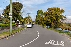
Dallington is a suburb in Christchurch, New Zealand. It's located on the north-east side of the city.
It is mainly bordered by the Avon River / Ōtākaro. The suburb stretches in a circular area. Its neighbours are Burwood, Shirley, Richmond, and Avonside.
Dallington was first mentioned in a newspaper in 1883. At that time, "beautiful suburban villa sites" (places for nice homes) along the Avon River were advertised for sale.
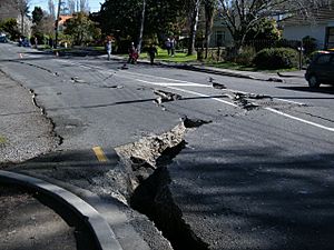
Dallington was hit hard by a big earthquake in September 2010. This caused a lot of damage to buildings. For example, St Paul's church and school had to move their services and students to other colleges while repairs were planned.
Then, in February 2011, an even stronger earthquake hit Christchurch. This caused much worse damage to the city. Because of this, large parts of Dallington were put into a special area called a residential red zone. This meant that houses in these areas were bought by the government and then taken down because they were too damaged or unsafe to live in.
About the People
Dallington covers about 0.83 square kilometres. In 2018, about 2,361 people lived there. This was a bit more than in 2013, but fewer than in 2006.
In 2018, there were slightly more males than females. The average age was about 36.4 years old. About 1 in 5 people were under 15 years old.
Most people living in Dallington are of European background (about 81%). Other groups include Māori (about 14%), Pasifika (about 6%), and Asian (about 8%). Some people identify with more than one group.
About 21% of people in Dallington were born outside New Zealand.
Education
Pareawa Banks Avenue School is a primary school in Dallington. It teaches students from Year 1 to Year 6. The school opened in 1956. As of 2023, it had about 339 students.
 | Valerie Thomas |
 | Frederick McKinley Jones |
 | George Edward Alcorn Jr. |
 | Thomas Mensah |


