Shirley, New Zealand facts for kids
Quick facts for kids
Shirley
|
|
|---|---|
|
Suburb
|
|

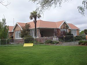
The Shirley Community Centre displaying significant earthquake damage
|
|
| Country | New Zealand |
| Local authority | Christchurch |
| Electoral ward |
|
| Area | |
| • Land | 333 ha (823 acre) |
| Population
(June 2023)
|
|
| • Total | 6,870 |
|
|
||
Shirley, also sometimes called Windsor, is a suburb in Christchurch, New Zealand. It is located about 5 kilometres (3.1 miles) north-east of the city centre. For many years, starting in the 1850s, the area was used for farming. People began to divide the land into smaller sections in the early 1900s. Most of the houses you see in Shirley today were built between 1950 and 1980.
Contents
History of Shirley
Shirley is built on very flat land. Before the first European settlers arrived in the 1850s, this area had many streams. These streams flowed into marshy wetlands, which were found between sandy hills covered in grass.
Early Farming Days
Just a few years after settlers arrived, people started raising sheep and dairy cows here. This land was part of a large farm called the Sandhills station. From 1863 onwards, families of small farmers began to buy land. For the rest of the 1800s, Shirley was a mix of market gardens, dairy farms, and small grazing farms. Hedges often divided these farms.
You could find a farmhouse and stables every few hundred metres along the roads. As more land was drained, it became very good for growing crops. A very rich family, the Rhodes family, owned a large estate in the area. They did not live there but had managers run their farm.
Who Settled in Shirley?
Most of the early settlers in Shirley came from England and Scotland. Some Irish families also made their home here. In the 1870s, a group of Polish families from eastern Germany also settled in the area. Around this time, a small village began to grow. It had shops and a church or two, mainly along what is now known as Shirley Road.
How Shirley's Homes Were Built
Most of the houses in Shirley were built between 1950 and 1980. After World War II, a large area of state housing was built on the western side of the suburb. This area was known as the Emmett Block. On the eastern side, private companies, like Paramount Homes, built most of the houses.
The typical house built by these developers was a one-storey bungalow. These homes usually had three or four bedrooms and a low roof. The streets sometimes followed old stream paths or curved in new ways. Some streets ended in cul-de-sacs, which are dead-end streets. The people living in Shirley have always had an average income compared to other Christchurch suburbs. The streets in the Emmett Block generally had lower incomes.
The Name Shirley
The suburb of Shirley got its name from a woman named Susannah Buxton. Her maiden name was Shirley. When she was very ill in 1868, she asked her son, Joseph Shirley Buxton, to give land to the Methodists. She wanted them to build a church there. Her son did as she asked, and the church was named the Shirley Methodist Church in her honour. Over time, the whole suburb became known as Shirley because of this church.
From North Richmond to Windsor and Shirley
When people first started dividing the land into sections in the early 1900s, the area was called North Richmond. Later, the name changed to Windsor. However, at a meeting at the Windsor Wesleyan School, land agents suggested that land sold better if the area was called Shirley instead of Windsor.
So, the name Windsor became less popular for the suburb itself. But you can still find the name Windsor in places like the Windsor Golf Club, Windsor Service Station, Windsor House, and Windsor School.
Shirley's People
Shirley is divided into two statistical areas: Shirley West and Shirley East. Together, they cover about 3.33 square kilometres (1.29 square miles). As of 2023, Shirley has an estimated population of about 6,800 people. This means there are around 2,000 people living in each square kilometre.
Population Changes
The population of Shirley has grown slowly over the years.
- In 2006, there were 6,579 people.
- In 2013, the population was 6,588.
- By 2018, it had increased to 6,852 people.
In 2018, there were 2,457 households in Shirley. There were slightly more females than males. About 19% of the people were under 15 years old, and 17% were 65 or older.
Cultural Backgrounds
Shirley is a diverse place. In 2018, about 80% of the people were European/Pākehā. Other groups included:
- 13% Māori
- 5% Pasifika
- 11% Asian
- 2.5% other ethnicities
About 20% of Shirley's residents were born overseas. This is a bit lower than the national average for New Zealand, which is 27%.
Religious Beliefs
When asked about their religion in 2018, nearly half of Shirley's residents (49.8%) said they had no religion. About 38% were Christian. Smaller numbers followed other religions like Māori religious beliefs, Hinduism, Islam, and Buddhism.
Services in Shirley
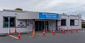
Shirley has several important services and facilities for its residents.
One of the biggest shopping centres in Christchurch, The Palms Shopping Centre, is located in Shirley. You can also find the Shirley Golf Course and a Bunnings Homebase store here.
The Shirley Community Centre was once the original building for Shirley Primary School. It was considered a special heritage building. Sadly, it was badly damaged during the February 2011 Christchurch earthquake and has since been taken down.
Schools in Shirley
Shirley has several schools that serve different age groups.
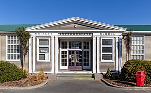
- Shirley Intermediate School is for students in Years 7 and 8. It opened in 1934 and has about 300 students.
- Shirley Primary School teaches students from Years 1 to 6. It opened in 1916 and has about 250 students.
- Kingslea School is a special school with about 100 students.
Some schools that were once in Shirley have moved or closed due to earthquake damage.
- Shirley Boys' High School opened in 1957. Its original site was damaged in the 2011 Christchurch earthquakes. The school moved to North New Brighton in 2019.
- Marian College was a Catholic girls' secondary school in Shirley. After the 2011 earthquake, it moved to share a space with Catholic Cathedral College in the city centre. It plans to move to a new site in Northcote in 2023.
- Quinns Road School opened in 1955 and was later renamed Hammersley Park School. It closed in 2012 because of earthquake damage and a drop in student numbers.
 | Precious Adams |
 | Lauren Anderson |
 | Janet Collins |


