
Dawesville Channel facts for kids

The Dawesville Channel (also called the Dawesville Cut) is a man-made waterway in Western Australia. It connects the Peel-Harvey Estuarine System to the Indian Ocean. This channel is located near Dawesville, about 80 kilometres south of Perth. It sits south of the city of Mandurah and north of Yalgorup National Park.
This channel was built to solve a big environmental problem. It lets ocean water flow in and out of the estuary with the daily tides. This movement helps stop harmful algae from building up. Before the channel, the Peel-Harvey Estuary was very polluted. It was full of rotting algae, especially in summer, which smelled bad. Fish and crabs were disappearing, and people couldn't enjoy the water. This problem became a major concern for the government in the 1980s.
Contents
Why Was the Channel Needed?

Every year, from May to October, about 1000 millimetres of rain falls in the areas around the Murray, Serpentine, and Harvey rivers. This is almost all the rain the region gets because summers are very dry.
Early European settlers found these flat areas often flooded for many months. Later, people built drains to remove excess water and create land for farming. Forests were also cut down. Over 100 years of development changed the soil. Rainwater quickly ran into drains instead of soaking into the ground. Farmers then used a lot of superphosphate (a type of fertiliser) to help their crops grow.
In the early 1970s, some industries, like a large pig farm, also released a lot of nutrients into the river system.
By the 1970s and 1980s, all these nutrients caused the estuary to become eutrophic. This means it had too many nutrients, leading to huge growths of algae. These included toxic blue-green algae called nodularia spumigena. The mix of sunlight, warm water, and lots of nutrients caused massive algal blooms. These blooms made the water look green and slimy. At the same time, more and more people were moving to the coast near Mandurah.
Trying to Fix the Algae Problem
For over 20 years, the government and farming groups tried to solve the algae problem. It was a huge challenge, and no one could agree on the main cause. Everyone blamed each other, and the problem just got worse.
Some of the things they tried included:
- Developing a special fertiliser that held its nutrients longer.
- Spreading bauxite tailings (waste from aluminium mines) on farmland.
- Replanting trees in cleared areas.
- Restoring places where water animals lived.
- Moving some big industries, like the pig farm, away from the river.
- Teaching farmers better ways to farm and limiting how much phosphate fertiliser they could use.
- Using machines to collect algae from the estuary shores and truck it away.
The Big Solution: Building a New Channel
Scientists like Professor Arthur McComb and Ernest Hodgkin studied the problem. They found that the main cause of the algae blooms was too much phosphorus in the water. This phosphorus came from farms and industries in the area. They suggested that changing how fertiliser was used would help. But for a quick and big improvement, they said a new channel to the ocean was needed.
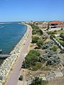
The idea was that a new channel would let more water flow between the estuary and the ocean. This would help flush the extra nutrients out to sea. It would also make the estuary water saltier, which would stop the blue-green algae from growing. The daily tides, which move the water about 1 metre, would help with this flushing. They also planned to make the natural opening of the estuary near Mandurah wider and deeper.
How the Channel Was Built
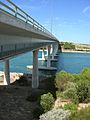
After several years of discussions, the decision was made to build the channel. It was estimated to cost $37 million. Construction started in 1990 and finished in April 1994. The channel is about 2.5 kilometres long, 200 metres wide, and 6 to 6.5 metres deep. Workers had to dig out about 4.5 million cubic metres of material. Besides digging, they also built walls to guide the water, a bridge, and a system to move sand.
The four-lane Port Bouvard Bridge crosses the channel. About 40,000 vehicles use this bridge every day. It is part of the Old Coast Road that connects Perth to towns further south. Many new homes and canals have been built along the channel, including the suburb of Wannanup. A golf course was also built nearby.
Since the channel opened, there have been no more blue-green algae blooms.
Keeping the Channel Clear: Sand Bypassing
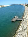
When the channel was built, a "sand trap" was included just south of the ocean opening. This trap catches sand that naturally moves along the coast from south to north. This sand movement is caused by the strong south-westerly winds. If the sand wasn't caught and moved, the channel would quickly fill up. There isn't enough water flow through the channel to wash the sand away naturally.
About 85,000 cubic metres of sand are moved mechanically from the south side to the north side of the channel each year. The sand is mixed with water to create a thick liquid called a slurry. This slurry is then pumped across the channel through one of two submerged pipes.
Images for kids
-
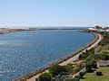
The Dawesville Channel opening
-
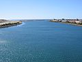
Another view of the channel opening
-
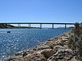
The channel with the bridge
-
The Port Bouvard Bridge
-
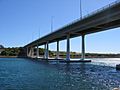
A closer look at the Bouvard Bridge
-
View from the bridge in 2007
-
View from the bridge in 2008


