Dells of the Eau Claire County Park facts for kids
Quick facts for kids Dells of the Eau Claire County Park |
|
|---|---|

Dells of the Eau Claire River
|
|
| Location | Marathon County, Wisconsin, USA |
| Nearest city | Town of Plover |
| Area | 190 acres (0.77 km2) |
| Governing body | Marathon County |
| [1] | |
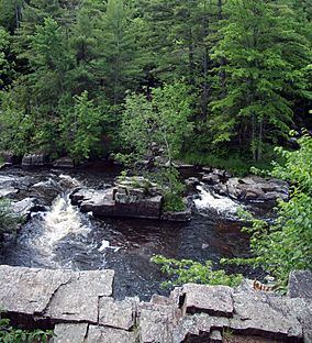
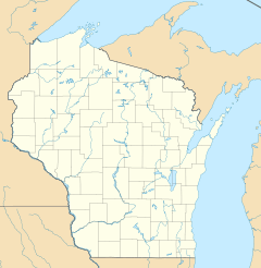
Dells of the Eau Claire County Park is a beautiful park in central Wisconsin. It's located near the town of Plover, east of Wausau. The park is split by the Eau Claire River. The river flows through a rocky gorge, creating cool waterfalls and rapids. You can see amazing rock formations and big boulders here. The river's depth changes depending on the time of year.
The park offers many fun activities. You can go camping, swimming, hiking, and picnicking. Even though it shares a name with the city of Eau Claire, Wisconsin, that city is far away. Also, don't confuse it with the Wisconsin Dells, which is another famous area with rock formations. In 2016, the park was added to the National Register of Historic Places. This means it's a special place with important history.
Contents
Park History: How it Began
The Dells of the Eau Claire County Park has a rich history. In 1923, Marathon County bought 60 acres of land around the Eau Claire River. This became the county's fourth park.
Early Park Planning
A landscape architect named Charles Ramsdell helped design the park. He planned trails, picnic spots, and a small shop. His goal was to keep the park looking natural and beautiful. He didn't want to add too many artificial things. In the 1920s and early 1930s, workers cleared brush and built stone steps. They even made a baseball field.
The Stone Bridge
The rustic stone bridge that crosses the river was built in 1927. It carries County K highway over the gorge. This bridge was designed to blend in with the natural surroundings. It has a strong concrete base covered with natural stone.
Master Plan and CCC Work
In 1937, another landscape architect, Ingwal S. Horgen, created a master plan for the park. He wanted to keep most of the park natural. He planned trails to show off the park's features. He also made sure large areas stayed as forest. The footbridge and other buildings were part of his plan. These buildings were built in a "Rustic-style," which was popular in parks back then. Much of Horgen's design is still used today.
The Civilian Conservation Corps (CCC) helped build many parts of the park. The CCC was a program during the Great Depression that gave young men jobs. From 1935 to 1942, they built the footbridge, stone steps, and other structures. They even used stones from the gorge itself for the footbridge. In 1973, the park became a State Natural Area. It was listed on the National Register of Historic Places in 2016.
Park Geography
The Eau Claire River flows through a rocky gorge in the park. This creates many waterfalls and rapids. A part of the famous Ice Age Trail also runs through the park. This trail follows features left behind by glaciers.
Amazing Geology
The rocks you see along the river are incredibly old. They are about 1.8 billion years old! These rocks are a type called rhyolite schist. They were formed deep underground and then tilted upright by powerful geological forces. This tilting created the tall, varied rock formations in the gorge. The northern part of the gorge has the highest tilted rocks. You might also see "potholes" in the rocks. These were made by sand and gravel swirling in the river's current over many years.
Park Plants and Trees (Flora)
The park is home to a northern "mesic" forest. This means it's a moist, balanced forest environment. You can find trees like hemlock, sugar maple, and yellow birch here. There are also smaller plants like mountain maple and Canada yew. These plants grow in the forested areas, along the river banks, and in the gorge.
Climate and Water Levels
Marathon County gets about 52 inches of snow each year. When this snow melts in the spring, it makes the Eau Claire River levels much higher. In the summer and fall, the water levels are usually lower. This is because there's less rain, typically only 4 or 5 inches per month.
Fun Activities (Recreation)
Most of the developed areas for fun activities are north of the Eau Claire River.
- Camping: North of the river, you'll find over 25 campsites. Sixteen of these have electricity.
- Swimming: There's a swimming beach above a small dam, about half a mile from the river gorge.
- Picnic and Play: East of the highway, there's a group campground, three shelters, and a playground.
- Hiking: Many nature trails wind through the park, both north and south of the river. They are great for exploring the natural beauty.
Safety in the Park
The park has signs to help visitors stay safe. A sign near the gorge warns people to be careful. It says, "Danger. Use only developed beach. Rocks – Undercurrent deadly." This means it's very important to swim only in the designated beach area. The rocks can be slippery, and the water currents can be strong and dangerous in other parts of the river. Always follow park rules and safety signs to have a fun and safe visit.
 | Kyle Baker |
 | Joseph Yoakum |
 | Laura Wheeler Waring |
 | Henry Ossawa Tanner |


