Dendora Valley facts for kids
Quick facts for kids Dendora Valley |
|
|---|---|

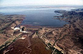
Painted Rock Dam and Gila River, eastern border of the Dendora Valley
(view due east) |
|
| Length | 9 miles (14 km) |
| Width | 6 miles (9.7 km) |
| Geography | |
| Borders on | Gila Bend Mountains-N Painted Rock Reservoir-E Painted Rock Mountains-S Hyder Valley-W |
| Rivers | Gila River |
The Dendora Valley is a small valley in Arizona, USA. It is located near the Gila River, just west of the Painted Rock Dam and its large reservoir. This valley sits north of the river and is west of the Painted Rock Mountains. These mountains form the western edge of the Painted Rock Reservoir.
Contents
What is the Dendora Valley?
The Dendora Valley is a narrow piece of land, about 9 miles (14 km) long. It is bordered by different mountain ranges. To the north, you'll find the Gila Bend Mountains. These mountains stretch from east to west and also form the northern edge of the Painted Rock Reservoir.
The Famous Gila Bend
The area is known for the "Gila Bend." This is where the Gila River makes a big turn. It changes direction, first flowing south, then west, as it enters the reservoir. This unique bend gives the nearby mountains their name.
Mountains Around the Valley
On the southwest side of the Dendora Valley, there are smaller mountains and hills. One of these is Oatman Mountain, which stands about 1,732 feet (528 m) tall. There's also a group of peaks called the Face Mountain group, which includes Montezuma Head further to the west.
How to Visit Dendora Valley
The easiest way to get to the Dendora Valley is from a place called Hyder. Hyder is located in the Hyder Valley, about 15 miles (24 km) to the west-southwest of Dendora Valley.
Finding Oatman Mountain
If you want to find Oatman Mountain, which is on the southwest border of the valley, you can use these coordinates: 33°3′6.1″N 113°8′5.6″W / 33.051694°N 113.134889°W. Coordinates are like a special address system using numbers to pinpoint locations on Earth.
 | William Lucy |
 | Charles Hayes |
 | Cleveland Robinson |


