
Denniston, New Zealand facts for kids
Quick facts for kids
Denniston
|
|
|---|---|

Denniston
Location in New Zealand
|
|
| Country | New Zealand |
| Region | West Coast |
| District | Buller District |
| Electorates | West Coast-Tasman Te Tai Tonga |
Denniston is a small place on the West Coast of New Zealand's South Island. It's about 15 kilometres (9 miles) east of Westport. Denniston sits on the Denniston Plateau, which is about 600 metres (2,000 feet) above sea level in the Papahaua Ranges.
The settlement is named after R. B. Denniston, who managed the first big mine in the area in the 1870s. In the early 1900s, Denniston was a busy coal mining town. Up to 1,400 people lived on the plateau to work in the large coal mines. Coal was moved from the plateau using a special railway called the Denniston Incline. It went down to Conns Creek, where trains took the coal to the port of Westport.
The Denniston Incline stopped working in 1967. Today, fewer than 10 people live on the plateau. Most of the old buildings are gone, but you can still find many historical items scattered around. A modern open-cast mine, the Escarpment Mine Project, started in 2014. However, it was paused in 2016 because of changes in the coal market.
Contents
What Was Denniston Like?

The towns on the Denniston Plateau and the Denniston Incline itself were built only to get coal out of the ground. Life in Denniston was very tough. The plateau is rocky and windy, often covered in clouds. It gets a lot of rain and has very cold temperatures.
Once better roads were built and less coal was needed, the towns started to shrink. They disappeared completely when the incline and mines closed. A former schoolhouse, which is now a museum, is one of the few buildings left. Not many people live on the plateau now, but more tourists are visiting to learn about its history. There is a chance that more open-cast mining could happen in the future.
Denniston's story is similar to Millerton, another mining town about 12 kilometres (7 miles) north.
Denniston's Past: A Mining Story
The Westport Coal Company
The Westport Colliery Company was formed in 1878. Its goal was to mine the excellent quality coal on the Mount Rochfort Plateau, also known as the Denniston Plateau. To reach the coal, the company built a railway extension to Conns Creek. They also built the famous Denniston Incline and special roads from the mines to the top of the incline.
In 1881, the company became the Westport Coal Company to get more money for mining. This company also ran mines in other places, like Millerton. By 1905, it was the biggest coal producer in New Zealand. The New Zealand State Mines Department took over the Westport Coal Company's mines and the Denniston Incline in 1948.
The Amazing Denniston Incline

The Denniston Incline started working in April 1880. It was a clever system that used gravity to move coal. Full coal wagons, weighing about 12.5 tons, would go down the incline from Denniston to Conns Creek. As a full wagon went down, it pulled an empty wagon up the incline using strong wire ropes.
The incline actually had two parts. The higher part went steeply down from Brakehead (at Denniston) to a spot called Middle Brake. Here, wagons were moved to the second part of the incline, which had a gentler slope down to Conns Creek. At Conns Creek, the coal wagons were gathered into trains and taken to Westport. The large drum from Middle Brake is now on display at Westport's Coaltown Museum.
The incline was very steep in some places, dropping 516 metres (1,694 feet) over 1,670 metres (1.04 miles). Wagons could be moved from Denniston to Conns Creek at a rate of 12 to 18 wagons per hour. The railway tracks were the standard New Zealand size, 3 feet 6 inches wide. The coal wagons used were mainly "Q" class hopper wagons. Their coal containers could be lifted by cranes at the port and emptied directly into ships.
Sometimes, the system didn't work perfectly. Collisions, wagons going off the tracks, and runaways were known to happen. You can still find parts of wrecked wagons near the old incline path.
Mines and Rope Roads
The Denniston Plateau had several mines, including Banbury, Ironbridge, Coalbrookdale, Whareatea, and Sullivan. The Banbury Mine was the first to open in 1880. A special horse tramway was built to carry coal from the Banbury Mine to the top of the incline. Later, steam engines replaced the horses, using an endless rope system to pull mine tubs. By 1889, this rope road system stretched about 2.4 kilometres (1.5 miles) past other mines.
In 1952, a new aerial ropeway was built. It was 4 kilometres (2.5 miles) long and used buckets to carry coal from the new Whareatea and Sullivan mines to Brakehead. The old rope road was no longer needed. The Coalbrookdale and Ironbridge mines had already closed in the mid-1940s.
Coal production from Denniston peaked in 1910, with 464 miners producing 348,335 tons of coal. Over its lifetime, the incline carried an estimated 12.6 million tons of coal. Some mining continued, and the Escarpment Mine operated from 1964 to 1982.
Life in the Mining Towns
There were three main towns on the Denniston Plateau: Denniston, Burnett's Face, and Coalbrookdale. There were no roads connecting them, so people walked along the rope roads to get around. The total population of the plateau reached its highest point in 1911, with over 1,400 people.
Denniston Town
The first settlement, called "The Camp," was built on a rock ledge below the main plateau. It was placed between two cliffs to protect it from the strong winds. The first workers at the Banbury Mine found the conditions very harsh, and many didn't stay long. However, by 1883, about a hundred people lived there, and they even had a school and a brass band.
By 1887, Denniston had three hotels, a post office, four general stores, butchers, and bakers. Living conditions were not good. Houses were small wooden buildings with corrugated iron roofs. There was no running water or baths in the homes. Toilets were outdoor sheds with cans that were emptied by special workers. Large families often lived in small two-room huts, especially during bad weather. There were no gardens or flowers.
Denniston was important for the start of the union movement in New Zealand. The country's first miner's union was formed here in 1884. Miners faced tough conditions, which led to their desire for better rights.
Denniston had a sports ground, sports clubs, and churches for different faiths. There were also several lodges, which were like social clubs that offered support to members. In those days, before government social welfare, these groups helped provide security for miners and their families. Miners even formed their own Medical Association in 1883, hiring a doctor to visit twice a week. A hospital opened in 1910, paid for by the community, to help with mining accidents. Denniston didn't have a cemetery because the ground was too hard. Bodies were taken to Waimangaroa for burial.
The population of Denniston town reached its peak in 1926, with 910 people. After the 1930s Depression and World War 2, people started to leave Denniston. Many houses were even moved in pieces to be rebuilt in Waimangaroa or Westport. Buses were later provided so remaining workers and their families could live in more comfortable places closer to the coast.
Burnett's Face
When the Ironbridge Mine opened, a new settlement called Burnett's Face grew about 2 kilometres (1.2 miles) from Denniston. It started with tents, but by 1891, it had wooden cottages, a school, two hotels, and several shops. Its main road was the busy rope road that connected the mine to the coal bins at the top of the Denniston Incline. By the 1950s, most of Burnett's Face was gone.
Coalbrookdale
Another town, Coalbrookdale, stretched along the rope road in the lower Coalbrookdale Valley. In 1891, there were about 21 buildings. The population was highest in 1896, with 165 people. Coalbrookdale had a hotel for a time. The last person living there permanently left in 1956.
The End of an Era
The Denniston community existed only to support the coal mines and the incline. Once a proper road was built from Waimangaroa to the plateau, people began to move away to the warmer climate below.
By the 1960s, less coal was needed, and the Denniston Incline closed on August 16, 1967. The railway line at the bottom of the incline was shortened. A few months later, in 1968, the aerial ropeway from the mines also closed. Coal was then trucked directly down the hill. In May 1968, an earthquake caused a lot of damage to the incline, making its closure permanent. What locals once called the "Eighth Wonder of the World" became a part of history.
Denniston Plateau Today
Preserving History
Not much of the Incline or the old towns remains, but you can still find historical items all over the area. Middle Brake is one of the best-preserved industrial sites because it was so hard to reach, so much equipment was left behind. At Brakehead and Denniston town, you can see the main street layout, building foundations, chimneys, and the square water tanks that many houses had. Most of the old building sites are empty and covered in low plants. Only a few buildings are still standing.
The former high school is now used as a museum and information centre by a group called The Friends of the Hill. Other remaining buildings are now privately owned. Denniston is listed as a Category 1 Historic Place, meaning it has special historical or cultural importance in New Zealand.
The Denniston Incline and the main historical areas are now looked after by the New Zealand Department of Conservation. At Brakehead, copies of some of the old railway tracks have been built, and three original "Q" wagons are on display.
The Friends of the Hill group works to protect Denniston's history and share it with visitors. Denniston is becoming a popular tourist spot, especially since the historical novel The Denniston Rose by Jenny Pattrick, set in the 1880s, brought more attention to the area.
Future Mining Possibilities
Coal is still mined on the Denniston Plateau on a small scale. More mining also happens about 9 kilometres (5.6 miles) north at the Stockton Mine near Millerton. In 2010, a company called Bathurst Resources announced the Escarpment Mine Project to mine more coal on the Denniston Plateau. This plan was strongly opposed by environmental groups.
In March 2013, the Environment Court gave Bathurst permission to go ahead with the project. However, groups like Forest & Bird said they would continue to fight against it.
Images for kids
-
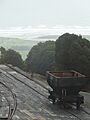
Top of Denniston Incline in 2013
-
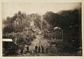
Bottom of Denniston Incline, c.1880s-90s.
