
Desolation Island (South Shetland Islands) facts for kids

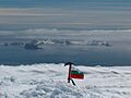
Desolation Island and Blythe Bay from Vidin Heights, Livingston Island
|
|
 |
|
| Geography | |
|---|---|
| Location | Antarctica |
| Coordinates | 62°27′27.9″S 60°20′48.3″W / 62.457750°S 60.346750°W |
| Archipelago | South Shetland Islands |
| Area | 3.12 km2 (1.20 sq mi) |
| Administration | |
| Administered under the Antarctic Treaty System | |
| Demographics | |
| Population | Uninhabited |

Desolation Island is a small island in Antarctica. It is part of the South Shetland Islands group. You can find it near the entrance to Hero Bay, which is close to Livingston Island.
The island has a V-shape. Its northern coast has a small bay called Kozma Cove. Desolation Island covers an area of about 3.12 square kilometers (1.2 square miles).
This island was discovered a long time ago. Captain William Smith found it on October 15, 1819. He was an English merchant captain. He visited the islands for the second time on his ship, the Williams.
A place called Blythe Bay is on the southeast side of Desolation Island. In the early 1800s, English and American sealers often used this bay. They would stop there while hunting seals.
Where is Desolation Island Located?
Desolation Island is in a very specific spot in the South Shetland Islands. Its center point is at 62°27′27.9″S, 60°20′48.3″W.
It lies about 6.9 kilometers (4.3 miles) northwest of Kotis Point. It is also about 8.7 kilometers (5.4 miles) west of Williams Point. And it is about 9.7 kilometers (6.0 miles) north-northeast of Siddins Point.
Many countries have mapped Desolation Island over the years. British maps were made in 1820 and 1968. Chile mapped it in 1971. Argentina made maps in 1980. Bulgaria also created maps in 2005 and 2009. This shows how important it is to keep track of places in Antarctica.
See also
 In Spanish: Isla Desolación (Antártida) para niños
Images for kids
-
Desolation Island and Blythe Bay from Vidin Heights, Livingston Island
-
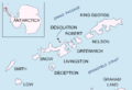
Location map of Desolation Island
