Dewar, Oklahoma facts for kids
Quick facts for kids
Dewar, Oklahoma
|
|
|---|---|

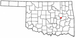
Location of Dewar, Oklahoma
|
|
| Country | United States |
| State | Oklahoma |
| County | Okmulgee |
| Area | |
| • Total | 1.02 sq mi (2.64 km2) |
| • Land | 1.01 sq mi (2.62 km2) |
| • Water | 0.01 sq mi (0.02 km2) |
| Elevation | 646 ft (197 m) |
| Population
(2020)
|
|
| • Total | 763 |
| • Density | 753.95/sq mi (291.17/km2) |
| Time zone | UTC-6 (Central (CST)) |
| • Summer (DST) | UTC-5 (CDT) |
| ZIP code |
74431
|
| Area code(s) | 539/918 |
| FIPS code | 40-20500 |
| GNIS feature ID | 2412423 |
Dewar is a small town in Okmulgee County, Oklahoma, United States. In 2020, about 763 people lived there.
The town was started in 1909 by people working for the Missouri, Oklahoma and Gulf Railway (MO&G). It was named after William Peter Dewar, who was an official for the railway company. Dewar officially became a town in 1909.
Dewar has a history with coal mining. The area is part of the large Henryetta Coal Formation. In 1943, four coal companies in Dewar produced over 13,600 tons of coal every year. These companies were Berkey Coal Company, Coal Creek Coal Company, Dewar Coal Company, and Martin-Geary Coal Company.
A special railway line, first called the Coalton Railway and later the Okmulgee Northern Railway, ran through Dewar. It operated from 1916 to 1964. This railway helped carry coal from Dewar and nearby towns like Coalton and Schulter to other places.
Geography of Dewar
Dewar is located in Oklahoma. According to the United States Census Bureau, the town covers a total area of about 1.02 square miles (2.64 square kilometers). Most of this area is land, with a very small part being water.
People in Dewar
The number of people living in Dewar has changed over the years. Here's how the population has looked:
| Historical population | |||
|---|---|---|---|
| Census | Pop. | %± | |
| 1920 | 1,558 | — | |
| 1930 | 994 | −36.2% | |
| 1940 | 778 | −21.7% | |
| 1950 | 1,015 | 30.5% | |
| 1960 | 817 | −19.5% | |
| 1970 | 933 | 14.2% | |
| 1980 | 1,048 | 12.3% | |
| 1990 | 921 | −12.1% | |
| 2000 | 919 | −0.2% | |
| 2010 | 888 | −3.4% | |
| 2020 | 763 | −14.1% | |
| U.S. Decennial Census | |||
In 2000, there were 919 people living in Dewar. These people lived in 344 households, and 261 of these were families. The town had about 999 people per square mile.
Many households in Dewar were families. About 34% of households had children under 18 living with them. Most households (58.4%) were married couples living together. Some households (12.8%) were led by a female without a husband present.
The people in Dewar were of different ages. About 27% were under 18 years old. About 13% were 65 years or older. The average age in the town was 35 years.
See also
 In Spanish: Dewar (Oklahoma) para niños

