Diamond Heights, San Francisco facts for kids
Quick facts for kids
Diamond Heights
|
|
|---|---|

Diamond Heights and Glen Canyon Park
|
|
| Area | |
| • Total | 1.13 km2 (0.436 sq mi) |
| • Land | 1.13 km2 (0.436 sq mi) |
| Population | |
| • Total | 2,332 |
| • Density | 2,064/km2 (5,345/sq mi) |
| 2008 | |
| ZIP Code |
94131
|
| Area codes | 415/628 |
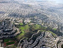
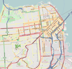
Diamond Heights is a cool neighborhood in the middle of San Francisco, California. It's surrounded by places like Noe Valley and Glen Canyon Park. This area is built on three hills: Red Rock Heights, Gold Mine Hill, and Fairmount Heights (which includes Billy Goat Hill).
Contents
Building Diamond Heights
Diamond Heights was part of a big city plan from 1948 to 1978. It was the first project by a group called SPUR (San Francisco Planning and Urban Research Association). They wanted to build a new neighborhood on these hills in a smart way. Their goal was to work with the natural shape of the land.
Not many people had to move for this project. The plan included homes for different budgets, churches, schools, parks, and a shopping area.
How the Project Started
The city's Water Department spent over $500,000 to build a water system for the new neighborhood. The city's leaders, called the Board of Supervisors, discussed the plans for Diamond Heights. Some property owners wanted to make sure their rights were protected. They also wanted to be able to trade their land for other spots.
However, the Board of Supervisors decided not to add these changes to the plan. The final plan for Diamond Heights was officially approved on October 24, 1955.
Old Houses Remain
Even with all the new building, some old houses stayed. For example, a wooden house with its own garage is still standing at 70 Gold Mine Drive. Records show this house was built way back in 1895.
Exploring Diamond Heights
Diamond Heights has several interesting places to visit.
Shopping and Community Spots
The main shopping area is the Diamond Heights Shopping Center. It's located on Diamond Heights Boulevard. You can also find the San Francisco Police Department's police academy here. St. Nicholas Orthodox Christian Church is at the top of Diamond Heights Boulevard.
Parks and Playgrounds
There are two fun playgrounds in Diamond Heights. The George Christopher Playground is right behind the shopping center. The Walter Haas Playground is at the corner of Diamond Heights Boulevard and Addison Street.
Schools and Public Transport
Just northwest of Diamond Heights is the Ruth Asawa School of the Arts. This is a high school for students interested in the arts.
Getting around Diamond Heights is easy with public transportation. The Muni bus lines 35 Eureka, 48 Quintara, and 52 Excelsior serve the area. These buses connect to the Muni Metro train system. The 35 bus goes to Castro Street Station, the 48 to West Portal Station, and the 52 to Forest Hill Station. Also, the 35 and 52 buses connect to the Bay Area Rapid Transit (BART) train system at the Glen Park Station.


