Dickens, Nebraska facts for kids
Quick facts for kids
Dickens, Nebraska
|
|
|---|---|

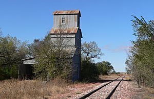
Abandoned grain elevator in Dickens
|
|
| Country | United States |
| State | Nebraska |
| County | Lincoln |
| Elevation | 3,136 ft (956 m) |
| Time zone | UTC-6 (Central (CST)) |
| • Summer (DST) | UTC-5 (CDT) |
| ZIP codes |
69132
|
| GNIS feature ID | 835287 |
Dickens is a small, quiet community in the southwestern part of Lincoln County, Nebraska, in the United States. It's not a city or town with its own government, which is why it's called an unincorporated community. Dickens is located along Nebraska Highway 23, southwest of North Platte, which is the main city in Lincoln County. The land here is quite high, about 3,136 feet (956 meters) above sea level. This community was named after the famous writer, Charles Dickens. Even though it's a small place, Dickens has its own post office with the ZIP code 69132.
How Dickens Began
Early Days and the Railroad
Dickens started to grow in the 1880s. This happened after the Chicago, Burlington and Quincy Railroad built its tracks through the area. The railroad helped connect the community to other places. It also made it easier for people and goods to travel.
 | James Van Der Zee |
 | Alma Thomas |
 | Ellis Wilson |
 | Margaret Taylor-Burroughs |


