
Dickson City, Pennsylvania facts for kids
Quick facts for kids
Dickson City, Pennsylvania
|
||
|---|---|---|
|
Borough
|
||
 |
||
|
||

Location of Dickson City in Lackawanna County, Pennsylvania
|
||

Dickson City, Pennsylvania
Location in Pennsylvania

Dickson City, Pennsylvania
Location in the United States
|
||
| Country | United States | |
| State | Pennsylvania | |
| County | Lackawanna | |
| Founded | unknown date, probably c. 1863? | |
| Area | ||
| • Total | 4.79 sq mi (12.42 km2) | |
| • Land | 4.79 sq mi (12.42 km2) | |
| • Water | 0.00 sq mi (0.00 km2) | |
| Elevation | 827 ft (252 m) | |
| Population
(2020)
|
||
| • Total | 6,038 | |
| • Density | 1,259.23/sq mi (486.15/km2) | |
| Time zone | UTC-5 (EST) | |
| • Summer (DST) | UTC-4 (EDT) | |
| Zip Code |
18508, 18519, 18447 (Miles Plot area, shared with Olyphant)
|
|
| Area code(s) | 570/272 | |
| FIPS code | 42-19160 | |

Dickson City is a small town, known as a borough, in Lackawanna County, Pennsylvania, United States. It is about 4 miles north of Scranton. In the past, coal mining was a very important industry here. The town's population was largest in 1930 with 12,395 people. In 2020, about 6,051 people lived there.
Contents
History of Dickson City
Dickson City was once called Priceburg. It was a new and growing village in the valley. In 1863, German immigrants started a village called Priceville. They named it after Eli Price. This area grew quickly after 1880 when John Jermyn opened a coal mine. The population here jumped from 329 to 841 people.
In June 1875, Dickson City officially became a borough. At that time, it also included the area that is now Throop. Dickson City got its name from Thomas Dickson. He was the person who started the Dickson Manufacturing Company.
From Coal Mines to Shopping Centers
For a long time, coal mines were the main business in Dickson City. But in recent years, the town has become a major shopping area. Many large stores and restaurants are located along Business Route 6 and near the Viewmont Mall.
Most of the newer shopping areas were built on land that used to be coal mines. Developers built places like Dickson City Crossings and Commerce Plaza. These areas helped bring many businesses to the borough.
Main Street is another important road in Dickson City. It has older shops, bars, offices, and homes.
Public Land and Development
There was a large piece of land, about 240 acres, that used to be a coal mining area. The state government cleaned it up and gave it to the borough for public use. There were plans to build a golf course on this land. However, some local leaders disagreed with borrowing money for it. The land was later taken by a bank because loans were not paid. Since the state said the land had to belong to a town, the nearby borough of Dunmore took it over.
Geography of Dickson City
Dickson City is located at 41°27′58″N 75°37′31″W / 41.46611°N 75.62528°W. The United States Census Bureau says the borough covers about 4.8 square miles, and all of it is land.
Interstate 81 has two important exits in Dickson City. One connects to Main Avenue, and the other connects to the old Route 6 (the Scranton-Carbondale Highway). The Viewmont Mall is partly in Dickson City and partly in Scranton.
Population Information
| Historical population | |||
|---|---|---|---|
| Census | Pop. | %± | |
| 1870 | 391 | — | |
| 1880 | 838 | 114.3% | |
| 1890 | 3,110 | 271.1% | |
| 1900 | 4,948 | 59.1% | |
| 1910 | 9,331 | 88.6% | |
| 1920 | 11,049 | 18.4% | |
| 1930 | 12,395 | 12.2% | |
| 1940 | 11,548 | −6.8% | |
| 1950 | 8,948 | −22.5% | |
| 1960 | 7,738 | −13.5% | |
| 1970 | 7,698 | −0.5% | |
| 1980 | 6,699 | −13.0% | |
| 1990 | 6,276 | −6.3% | |
| 2000 | 6,205 | −1.1% | |
| 2010 | 6,070 | −2.2% | |
| 2020 | 6,051 | −0.3% | |
| 2021 (est.) | 6,033 | −0.6% | |
| Sources: | |||
Population in 2010
In 2010, there were 6,070 people living in Dickson City. There were 2,703 households, and 1,636 families. About 22.7% of households had children under 18. The average household had 2.24 people.
The population was spread out by age. About 18.9% were under 18 years old. About 62% were between 18 and 64 years old. And 19.1% were 65 years or older. The average age was 42.3 years.
Population in 2000
In 2000, there were 6,205 people living in the borough. There were 2,692 households. About 25.1% of households had children under 18. The average household size was 2.30 people.
The population's age breakdown was similar. About 19.9% were under 18. About 28.6% were between 25 and 44. And 21.6% were 65 or older. The average age was 41 years.
Education in Dickson City
Dickson City is part of the Mid Valley School District.
Past Schools
When coal mining was a big industry, Dickson City had many local schools. These included the Columbus School, Jefferson School, Lafayette School, Lincoln School, and Wilson School. There was also a Dickson City Junior High School and a Senior High School.
School Changes Over Time
As the town's population became smaller, many of the neighborhood schools closed. The junior high school then became a school for kindergarten through 8th grade. In 1969, the school districts of Olyphant, Dickson City, and Throop joined together. They formed the Mid Valley School District.
The old Dickson City Junior High School became Mid-Valley Junior High School. The Senior High School became Dickson City Elementary School. Today, the Mid-Valley School District has one elementary school and one secondary school, both located in Throop.
Other Educational Opportunities
Johnson Technical Institute is a college located very close by in Scranton. Dickson City also has a family service center for Commonwealth Charter Academy. This is an online public virtual charter school for students from kindergarten to 12th grade.
Images for kids
-
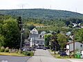
A view of Dickson City, Pennsylvania.
-
The flag of Dickson City.
-
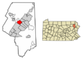
A map showing Dickson City in Lackawanna County.
See also
 In Spanish: Dickson City para niños
