Dingwall Canal facts for kids
Quick facts for kids Dingwall Canal |
|
|---|---|

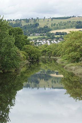
The canal in 2009
|
|
| Specifications | |
| Locks | 0 |
| Status | reverted to river |
| History | |
| Principal engineer | Thomas Telford |
| Date completed | 1816 |
| Date closed | 1880s |
| Geography | |
| Start point | Dingwall |
| Connects to | Cromarty Firth |
The Dingwall Canal was a short waterway in Scotland. It connected the town of Dingwall to the Cromarty Firth. This canal was built to help boats reach Dingwall more easily. It was finished by 1819. However, it wasn't very successful and stopped being used in the 1880s. This happened after trains started carrying goods instead.
Contents
Building the Dingwall Canal
Long ago, in 1578, a map of Scotland showed Dingwall as an important town. In 1587, King James VI gave Dingwall a special charter. This charter mentioned small boats using the river.
However, getting to Dingwall by boat became hard. Mud and dirt from the Conon and Orrin rivers filled up the waterways. By 1773, the town was struggling because of this.
In 1815, a big plan was started to fix the problem. The River Peffery was made deeper and wider. This allowed boats to reach the town again. The famous engineer Thomas Telford designed the project.
He planned to move the river temporarily. This allowed workers to dig a new, better path for it. The work was finished by 1819. The whole project cost about £4,365. The town of Dingwall helped by giving £100 in 1815.
Life of the Canal
The canal was not a big money-maker. It only brought in about £100 each year. In 1828, Thomas Telford said that repairs costing £800 were needed. The town council asked for help to manage it. But they ended up still running it themselves.
By 1838, the canal was considered a good place for boats. It was like a safe harbor. Ships could dock there away from the muddy areas. Goods like coal and lime came into Dingwall. Grain, wood, and tree bark were sent out.
Why the Canal Closed
The canal was about 1.1 miles (1.8 km) long. It was only used for a short time. In 1863, the Inverness and Ross-shire Railway came to Dingwall. Two years later, it became part of the Highland Railway.
Once the trains arrived, most of the goods were carried by rail. The canal lost nearly all its business. By the 1880s, people stopped using the canal.
A bridge for the railway crosses the canal. This bridge is now a special old building. Just north of the canal, the railway splits. One line goes north to Wick and Thurso. The other goes west to the Kyle of Lochalsh. The old harbor at the canal's mouth and a footbridge nearby are also special old structures.
The Canal Today
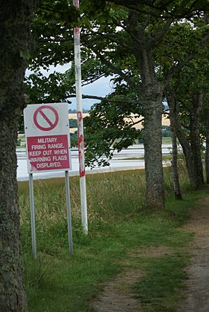
Today, you can still walk along the canal's path. It's a nice walk from the town to a picnic spot on the Cromarty Firth. There is a nearby area where people practice shooting. So, you might see red warning flags and signs. These tell you when it's not safe to use the path.
Dingwall has a special fund called the Common Good Fund. This fund helps the people of the town. The old part of Jubilee Park is next to the canal. Documents for this park suggest the canal is part of this fund. However, no papers have been found to fully prove this.
Places to See
| Point | Coordinates (Links to map resources) |
OS Grid Ref | Notes |
|---|---|---|---|
| Tulloch Street bridge | 57°35′54″N 4°25′44″W / 57.5984°N 4.4289°W | NH549590 | Dingwall |
| Railway bridge | 57°35′54″N 4°25′15″W / 57.5983°N 4.4208°W | NH554590 | |
| Junction with Cromarty Firth | 57°35′34″N 4°24′31″W / 57.5928°N 4.4085°W | NH561584 |
 | Ernest Everett Just |
 | Mary Jackson |
 | Emmett Chappelle |
 | Marie Maynard Daly |


