
Dismal Creek facts for kids
Quick facts for kids Dismal Creek (conservation area) |
|
|---|---|

Dismal Creek (conservation area)
Location in Virginia
|
|
| Location | Giles County Bland County Virginia, United States |
| Nearest town | White Gate, Virginia |
| Area | 7,008 acres (28.36 km2) |
| Administrator | U.S. Forest Service |
Dismal Creek is a special natural area, or "wildland," located in the George Washington and Jefferson National Forests in western Virginia. It's a place that the Wilderness Society believes should be protected. They call it a "Mountain Treasure" because it's so important to keep safe from things like logging and building new roads.
This large area has many trails and beautiful streams. It's a popular spot for people who love to hike, hunt, ride horses, and fish. It's also part of a larger group of natural areas called the Angels Rest Cluster.
Contents
Exploring Dismal Creek
Dismal Creek is found in the Appalachian Mountains of Southwestern Virginia. It's about 3 miles west of a town called White Gate. The wildland mainly covers the area where Dismal Creek collects its water, like a big natural bowl. This bowl is surrounded by mountains: Flat Top Mountain to the northwest, Brushy Mountain to the southeast, and Sugar Run Mountain to the north.
Trails to Discover
You can explore Dismal Creek using several trails:
- The famous Appalachian Trail (AT) enters the area at Sugar Run Mountain. It then goes down and follows Dismal Creek.
- The Ribble Trail is another path that used to be part of the Appalachian Trail. It's marked with blue blazes (paint marks on trees) and connects back to the main AT.
Getting Around by Road
Some roads offer access to the area, especially from October to early January. These include Flat Top Road (USFS 201), Lions Den Road (USFS 1015), and Yancy Road (USFS 10281). Lions Den Road is best for vehicles that sit high off the ground.

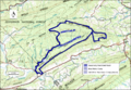
The map next to this text shows the boundaries of the Dismal Creek wildland. You can make the map bigger by clicking on the icon in the bottom right corner. For more details, you can find roads on National Geographic Map 787. You can also find lots of information, like maps and satellite views, by clicking on the coordinates link at the top right of this page.
Besides the main trails, you can also explore old logging roads. In the early 1900s, a lot of trees were cut down in the Appalachian Mountains. This left behind old roads that are now becoming overgrown but can still be used. You can find these old roads on historical maps from the United States Geological Survey (USGS). The Dismal Creek area is shown on the USGS maps called Narrows and Pearisburg.
Nature and Wildlife
Dismal Creek is part of a larger natural region known for its forests and meadows. Because it's a big area without many roads or homes, it's a great place for animals like black bears. Many types of birds that travel long distances also live here.
Special Plants and Water
A part of this wildland is called the Dismal Creek special biological area. Here, you can find unusual plants like piratebush and rare plants that love calcium, called calcium-loving plants. The area around Dismal Creek also has the uncommon northern white-cedar trees.
The area also has a fen, which is a unique type of wetland. Fens are rich in minerals and tend to be alkaline (the opposite of acidic). This is different from a bog, which is usually acidic.
The streams in Dismal Creek are known for their clean water. Virginia's Department of Game and Inland Fisheries ranks wild trout streams by water quality. Dismal Creek is rated as a class III stream, which means it has good water quality.
Some small areas of very old trees, called "old growth forest," have been found at high elevations. These special areas are protected by the Forest Service.
Mountains and Landscape
Dismal Creek includes the upper part of the Dismal Creek watershed. This means it has a mix of high ridges and forests along the floodplain (the flat land next to the creek). You can get amazing views from High Point, which is 3300 feet high and looks over Walker Creek Valley. Another great view is from the top of Flat Top Mountain, which is 4087 feet high and looks toward Sugar Run Mountain.
There are also old beaver ponds and a beautiful waterfall called the Falls of Dismal Creek. This waterfall is located near where the creek leaves the area.
The name "Dismal Creek" might sound a bit sad. It probably refers to the soil in the valley, which isn't very good for farming. The dark rock under the soil contains minerals called pyrites. When these pyrites break down, they make the soil acidic and not very fertile. This is different from nearby valleys that have limestone, which makes the soil less acidic and better for growing things.
How the Forest Service Manages the Area
The Forest Service looks at its lands to see which ones could be protected as "wilderness." Wilderness areas have a very high level of protection from development. Areas that are good for this are called inventoried roadless areas. Later, a "Roadless Rule" was put in place to limit building roads in these areas. This rule helps protect the environment by reducing the impact of road building and helps with the conservation of roadless areas.
However, Dismal Creek was not included in the original roadless area review. This means it doesn't have the same protection from new roads or timber sales.
The White Pine Horse Camp, which was once close to Dismal Creek, has been moved to a new spot. This new location is still within the larger Dismal Creek special biological area. The Forest Service chose the new site based on the land and existing facilities. They have also made the horse trail system bigger and are thinking about adding even more trails.
The Forest Service also categorizes different parts of the forest based on what kinds of outdoor activities you can do there. For example, some parts of Dismal Creek are labeled as "Appalachian Trail Corridor," "Old Growth with Disturbance," or "Rare Community." This helps visitors understand the different opportunities available.
Even though there are no plans for large-scale logging, the Forest Service does allow people to collect firewood along the roads in the area.
Images for kids
-
Boundary of the Dismal Creek wild area as identified by the Wilderness Society
