
Diu district facts for kids
Diu district is a small but interesting area in India. It's one of the two districts in the union territory of Daman and Diu. A union territory is like a special region directly managed by the Indian government. Diu is also one of the least populated districts in India.
Contents
Where is Diu District?
Diu district is quite small, covering about 40 square kilometers (which is around 15 square miles). It's made up of two main parts:
- Diu Island
- A small part on the mainland called the Ghoghla peninsula
There's also a village named Simbor about 20 kilometers (12 miles) east of Diu Island.
Diu Island: The Main Spot
Diu Island is where you'll find the main town of Diu. This island is also home to the famous Diu Fort.
The Mainland Area
The mainland part of Diu district shares a border with the Gir Somnath district in Gujarat. This area includes the village of Ghoghla. Ghoghla village is located on the mainland, right across from the eastern end of Diu Island.
Who Lives in Diu District?
According to a count done in 2011, Diu district has a population of 52,056 people. This number is similar to the population of a small country called Saint Kitts and Nevis. Out of all the districts in India, Diu ranks 631st in terms of population.
Population Details
- Population Density: About 1,301 people live in every square kilometer (or 3,370 people per square mile). This means it's quite crowded for its size.
- Population Growth: Between 2001 and 2011, the number of people living in Diu grew by about 17.73%.
- Sex Ratio: For every 1,000 males, there are 1,030 females. This is a good sign, as it means there are more females than males.
- Literacy Rate: About 83.36% of the people in Diu can read and write. This shows a good level of education in the district.
Images for kids
-
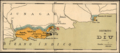
An old Portuguese map from the 1920s showing Diu District.
-
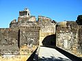
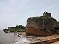
The Diu Fortress was built in 1535 by the Portuguese. They helped the Sultan of Gujarat to fight against an attack by the Mughal Emperor.
-
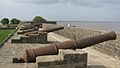
Cannons fixed at Diu Fort.
-
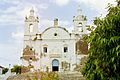
St. Thomas Church, Diu.
-
A view of Diu Fort.
-

The Nadia Caves in Diu.
-
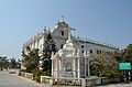
St. Paul's Church, Diu.
-
A church inside Nani Daman Fort.
-
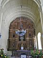
The altar of Se Cathedral.
-
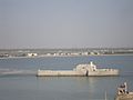
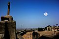
A view of the Water Fort Prison from Diu Fort, showing its watchtower.
-
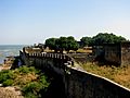
A wall of the Portuguese Fort of Diu.


.jpg)


