Dniester facts for kids
The Dniester River is a long and important river in eastern Europe. It starts high up in the Carpathian Mountains. The river flows through three different places: Ukraine, Moldova, and a region called Transnistria. After traveling for about 1,362 kilometers (840 miles), the Dniester finally reaches the Black Sea near the city of Odessa. It is the second longest river in Ukraine.
Quick facts for kids Dniester |
|
|---|---|

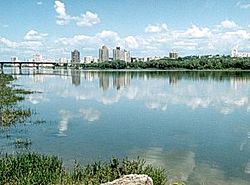
Rîbnița and the Dniester river
|
|

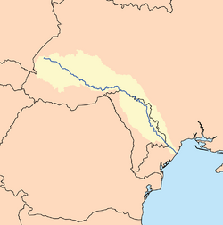
Map of the Dniester basin
|
|
| Country | Ukraine, Moldova, Transnistria (unrecognized) |
| Cities | Tiraspol, Bender, Rîbnița, Drohobych |
| Physical characteristics | |
| Main source | Eastern Beskids (Ukrainian Carpathians) 900 m (3,000 ft) 49°12′44″N 22°55′40″E / 49.21222°N 22.92778°E |
| River mouth | Black Sea Odessa Oblast 0 m (0 ft) 46°21′0″N 30°14′0″E / 46.35000°N 30.23333°E |
| Length | 1,362 km (846 mi) |
| Basin features | |
| Basin size | 68,627 km2 (26,497 sq mi) |
| Tributaries |
|
| Designation | |
| Official name: Lower Dniester | |
| Designated: | 20 August 2003 |
| Reference #: | 1316 |
| Official name: Dnister River Valley | |
| Designated: | 20 March 2019 |
| Reference #: | 2388 |
Contents
Where Does the Dniester River Flow?
The Dniester River starts in the Ukrainian Carpathians, which are part of the Carpathian Mountains. It begins in a mountain range called the Eastern Beskids. From there, it flows generally southeast.
How Long is the Dniester River?
The Dniester River is about 1,362 kilometers (840 miles) long. This makes it one of the longest rivers in eastern Europe. It carries a lot of water, with an average flow of about 310 cubic meters (10,950 cubic feet) per second.
Where Does the Dniester River Start and End?
The river's source, or starting point, is high in the mountains. It begins at an elevation of about 900 meters (2,950 feet) above sea level. The Dniester then travels across a large area. Its journey ends when it flows into the Black Sea. This happens near the city of Odessa in Ukraine. At its mouth, the river is at sea level.
Why is the Dniester River Important?
The Dniester River is very important for the countries it flows through. Many cities are located along its banks. These include Tiraspol, Bender, Rîbnița, and Drohobych. The river provides water for people and farming. It also serves as a natural border in some places.
The Dniester and Nature
Parts of the Dniester River are recognized as Ramsar sites. These are special wetlands that are important for nature and wildlife around the world. The "Lower Dniester" and "Dnister River Valley" are two such areas. This means the river's environment is protected because it is home to many different plants and animals.
Images for kids
-
Dnister's riverhead in Staryi Sambir (western Ukraine)
-
The Dniester at the Moldavian fortress of Tighina.
See also
 In Spanish: Dniéster para niños
 | Precious Adams |
 | Lauren Anderson |
 | Janet Collins |


