Dobson, New Zealand facts for kids
Quick facts for kids
Dobson
|
|
|---|---|

State Highway 7 outside Dobson
|
|
| Country | New Zealand |
| Region | West Coast |
| District | Grey District |
| Ward | Eastern |
| Electorates |
|
| Area | |
| • Total | 6.09 km2 (2.35 sq mi) |
| Population
(June 2023)
|
|
| • Total | 620 |
| • Density | 101.8/km2 (263.7/sq mi) |
| Local iwi | Ngāi Tahu |
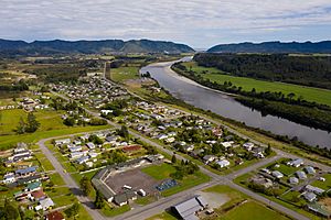
Dobson is a small town in the South Island of New Zealand. It is located on the banks of the Grey River. The town is about 10 kilometers (6 miles) east of Greymouth, where the river meets the sea. State Highway 7 runs right through Dobson.
Contents
History of Dobson
How Dobson Got Its Name
Dobson is named after a surveyor named George Dobson. A surveyor is someone who measures land and maps it out. George Dobson was sadly killed here in 1866. He was mistaken for a gold buyer carrying gold from a nearby goldfield. A goldfield is an area where gold is found. A monument now stands where he was killed.
Dobson's Mining Past
Dobson was once an important place for coal mining. The Dobson mine opened in 1919. It operated for many years before closing in 1968. This mine was also the site of a very sad event. In 1926, nine men lost their lives in an explosion at the mine. This was one of the worst mining disasters in New Zealand's history.
Hydroelectric Dam Proposal
In 1999, a company called TrustPower wanted to build a hydroelectric dam near Dobson. A hydroelectric dam uses water to create electricity. However, the plan did not go ahead. This was because they could not get permission to flood public land needed for the dam.
People and Population
Dobson and the nearby settlement of Taylorville are considered a rural area. Together, they cover about 6.09 square kilometers (2.35 square miles). In 2018, the estimated population for Dobson and Taylorville was 570 people.
| Historical population for Dobson and Taylorville | ||
|---|---|---|
| Year | Pop. | ±% p.a. |
| 2006 | 597 | — |
| 2013 | 564 | −0.81% |
| 2018 | 570 | +0.21% |
Most people living in Dobson and Taylorville are of European background. About 13% of the people identify as Māori. Many people in the area (56.3%) said they had no religion in the 2018 census. About 26.3% identified as Christian.
Education in Dobson
Dobson has one school called Paparoa Range School. It is a school for both boys and girls. It teaches students from Year 1 to Year 8, which is primary school. As of 2023, the school has about 120 students. Paparoa Range School was created in 2005. This happened when four smaller schools merged together. These schools were Blackball, Kaiata, Stillwater, and Brunnerton Primary Schools. The new school is located on the old Brunnerton Primary School site.
 | Ernest Everett Just |
 | Mary Jackson |
 | Emmett Chappelle |
 | Marie Maynard Daly |

