
Dows, Iowa facts for kids
Quick facts for kids
Dows, Iowa
|
|
|---|---|
| Motto(s):
A good town in a friendly community!
|
|

Location of Dows, Iowa
|
|
| Country | |
| State | |
| Counties | Wright, Franklin |
| Area | |
| • Total | 0.79 sq mi (2.06 km2) |
| • Land | 0.77 sq mi (1.99 km2) |
| • Water | 0.03 sq mi (0.06 km2) |
| Elevation | 1,152 ft (351 m) |
| Population
(2020)
|
|
| • Total | 521 |
| • Density | 677.50/sq mi (261.55/km2) |
| Time zone | UTC-6 (Central (CST)) |
| • Summer (DST) | UTC-5 (CDT) |
| ZIP code |
50071
|
| Area code(s) | 515 |
| FIPS code | 19-22305 |
| GNIS feature ID | 0455978 |
Dows is a small city in Iowa, a state in the United States. It is located in both Franklin and Wright counties. In 2020, about 521 people lived there. Dows officially became a city on May 3, 1892.
Contents
History of Dows
Dows started in 1880 when a railroad was built through the area. The city is named after a railroad builder, Colonel William Greene Dows.

Exploring Historical Sites in Dows
The Dows Historical Society and local volunteers have worked hard to fix up several old buildings. Three of these buildings are so important that they are listed on the National Register of Historic Places. This means they are special places that should be protected.
- The Rock Island Depot was built in 1896. This old train station was bought and fixed up in 1988. Today, it's an Iowa Welcome Center. You can find old railroad items and things from the community's past here.
- The Quasdorf Blacksmith and Wagon Museum was built in 1899. It was restored in 1990. This museum has one of the best collections of blacksmith tools in the Midwest. A blacksmith is someone who works with metal, often making tools or fixing wagons.
- The Fillmore Building is a large, old building on Main Street. It was built in 1894 and has been home to many businesses over the years. In 1987, the historical society bought and restored it. In 1989, an antique shop called Dows Mercantile opened inside, covering three floors!
-
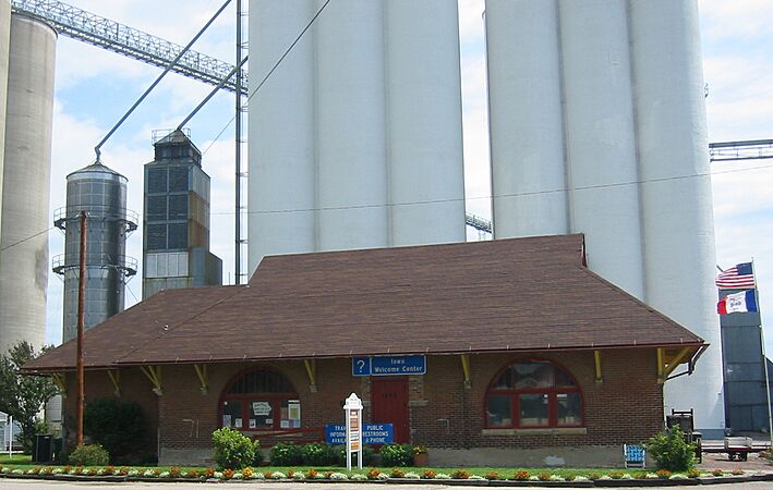
The old Burlington, Cedar Rapids & Northern Passenger Depot, which later became part of the Rock Island Railroad.
-
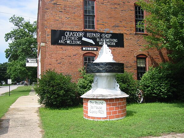
The Quasdorf Blacksmith and Wagon Museum.
-
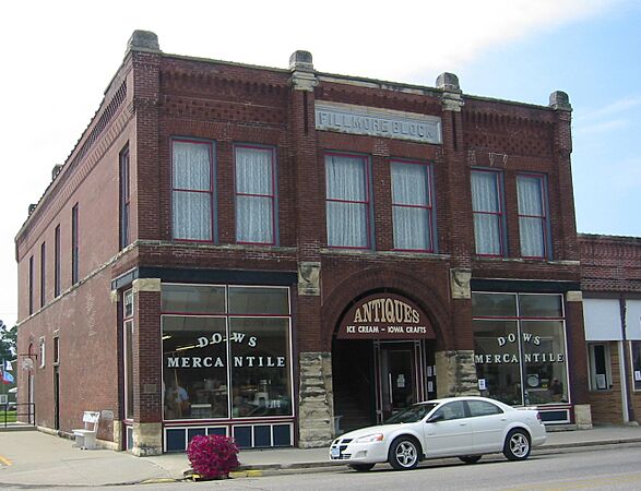
The historic Fillmore Building.


Another interesting old building is the Vernon Township Schoolhouse. It was built in 1887. This schoolhouse shows what typical one-room country schools were like a long time ago. It was moved to town and fixed up inside and out. It even has original desks, blackboards, and books! The Evans Prairie Home is another historical building in the downtown area.
Geography of Dows
Dows is located about 2 miles (3.2 km) west of Interstate 35. The city's exact location is 42°39′25″N 93°30′8″W / 42.65694°N 93.50222°W.
The city covers a total area of about 0.80 square miles (2.06 square kilometers). Most of this area, about 0.77 square miles (1.99 square kilometers), is land. A small part, about 0.03 square miles (0.06 square kilometers), is water.
Population of Dows
| Historical populations | ||
|---|---|---|
| Year | Pop. | ±% |
| 1900 | 818 | — |
| 1910 | 892 | +9.0% |
| 1920 | 1,145 | +28.4% |
| 1930 | 926 | −19.1% |
| 1940 | 945 | +2.1% |
| 1950 | 948 | +0.3% |
| 1960 | 882 | −7.0% |
| 1970 | 777 | −11.9% |
| 1980 | 771 | −0.8% |
| 1990 | 660 | −14.4% |
| 2000 | 675 | +2.3% |
| 2010 | 538 | −20.3% |
| 2020 | 521 | −3.2% |
| Source: and Iowa Data Center Source: |
||

Dows Population in 2020
In 2020, the city of Dows had 521 people living there. There were 242 households, which are groups of people living together in one home. The population density was about 677 people per square mile (261 per square kilometer).
Most of the people in Dows (about 79.5%) were White. About 24.6% of the population identified as Hispanic or Latino.
The average age of people in Dows was about 41.1 years old. About 23.4% of the residents were under 20 years old.
Dows Population in 2010
In 2010, Dows had 538 people and 250 households. The population density was about 698 people per square mile (270 per square kilometer).
Most residents (about 93.3%) were White. About 18.4% of the population was Hispanic or Latino.
The average age in Dows in 2010 was 47.8 years. About 19.5% of the people were under 18 years old.
Dows Community Convention Center
In 2003, the Dows Community Convention Center was built. It looks similar to an old building called the Exchange Block that used to be in town. The center has a large convention room that is about 4,800 square feet (446 square meters). It also has a smaller meeting room, a big kitchen, and good restrooms. The city offices are also located in this building.
Education in Dows
The Dows Community School taught students in the area for over 100 years. The first school building was built in 1914, and more parts were added over the years. The last class to graduate from Dows High School was in 1998.
After that, Dows schools started working with other school districts. First, they partnered with CAL Community School. Later, in 2005, Dows partnered with Clarion-Goldfield CSD. The Dows Elementary school stayed open until 2014. Now, the community is part of the Clarion–Goldfield–Dows Community School District. This new district was formed in 2014 when the Dows school district joined with the Clarion-Goldfield district. The old school property in Dows was later sold.
Churches in Dows
The Dows area has several churches. The Dows First Lutheran Church is part of the Evangelical Lutheran Church in America. The Dows United Methodist Church meets in its historic building, which was built in 1896. The Sovereign Grace Church is an independent church that meets in the building that used to be the First Presbyterian Church.
There are also some churches outside of town. The Morgan Methodist Church is six miles east of Dows. The Vernon Lutheran Church is southwest of town, but it no longer holds services. Some churches in Dows have closed, like the Dows First Presbyterian Church and Abundant Life Chapel. The Dows American Legion now owns the old First Presbyterian Church building, and you can rent it for events.
Dows Corn Days Celebration
Every year, on the first weekend in August, Dows celebrates with a big event called Dows Corn Days! It's a fun festival that includes:
- An exciting parade
- Entertainment in the park
- Food vendors selling tasty treats
- Inflatable rides for kids
- Lots of other activities
- A community church service
Images for kids
-
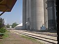
A view of Dows, Iowa.

See also
 In Spanish: Dows (Iowa) para niños
