
Doyle Road Covered Bridge facts for kids
Quick facts for kids Doyle Road Bridge |
|
|---|---|
_Covered_Bridge_1.jpg) |
|
| Coordinates | 41°45′44″N 80°47′25″W / 41.76222°N 80.79028°W |
| Locale | Ashtabula County, Ohio, United States |
| Characteristics | |
| Design | single span, Town truss |
| Total length | 94 feet (28.7 m) |
| History | |
| Construction begin | 1868 |

|
|

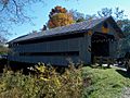
The Doyle Road Bridge is a cool covered bridge in Ashtabula County, Ohio, United States. It stretches across Mill Creek in Jefferson Township. This bridge is special because it's one of 16 covered bridges you can still drive across in the county! It uses a design called a Town truss, which is a type of wooden frame. When the bridge was fixed up in 1987, it got some extra support from laminated arches.
The bridge is about 1.9 mi (3.1 km) north of Jefferson. Its official number in the World Guide to Covered Bridges is 35-04-16.
Building the Doyle Road Bridge
The Doyle Road Bridge was first built in 1868. It crosses over Mill Creek, which got its name from the Mills family. They were some of the first settlers in that area.
Many years later, in 1987, the bridge was renovated. This means it was repaired and updated. During this renovation, laminated arches were added to make the bridge even stronger.
Bridge Design and Size
The Doyle Road Bridge uses a special design called a Town truss. This type of truss uses a crisscross pattern of wooden beams. This design helps to make the bridge strong and stable.
The bridge is 94 feet (29 m) long. That's about the length of two school buses! It also has an overhead clearance of 13 feet 3 inches (4.04 m). This means that vehicles up to that height can safely pass under the bridge.
Images for kids
-
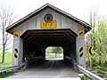
View from the northeast
-
-
_Covered_Bridge_2.jpg)
.jpg)
.jpg)
