
Draa River facts for kids
Quick facts for kids Draa Riverوادي درعة (Arabic) |
|
|---|---|
 |
|
.png)
Course of the Draa [1]
|
|
| Native name | وادي درعة (Arabic) |
| Countries | |
| Physical characteristics | |
| Main source | Dadès River |
| 2nd source | Imini River |
| River mouth | Atlantic |
| Length | 1100km |
| Basin features | |
| Progression | Southeast |
| Official name: Embouchure de l'oued Dr'a | |
| Designated: | 15 January 2005 |
| Reference #: | 1477 |
| Official name: Moyenne Dr'a | |
| Designated: | 15 January 2005 |
| Reference #: | 1482 |
The Draa River (also spelled Dra or Drâa) is Morocco's longest river. It stretches about 1,100 kilometers (680 miles). It starts where the Dadès River and Imini River meet in the High Atlas mountains. The river flows southeast towards Tagounite. From there, it mostly turns west until it reaches the Atlantic Ocean near Tan-Tan. In 1971, the (El) Mansour Eddahabi dam was built. This dam helps provide water to the city of Ouarzazate and controls the river's flow. For much of the year, the part of the Draa River after Tagounite dries up.
In the first half of the 20th century, the lower part of the Draa River marked the boundary between the French protectorate of Morocco and the area under Spanish rule.
Contents
Exploring the Draa River's Past
Ancient Life and Fossils
The Draa valley is home to special rock layers called the Fezouata formations. These formations contain amazing fossils from the Lower Ordovician period. This was about 485 to 470 million years ago. These fossils are very well preserved, similar to those found in the famous Burgess Shale. They show many ancient sea creatures that scientists once thought had disappeared much earlier. This makes the Fezouata formations a unique window into ancient life on Earth.
Early Human History

Evidence shows that people have lived in the Draa valley and nearby mountains for a very long time. Tools from the early Stone Age (Lower Paleolithic) have been found near Tamegroute. These tools include Oldowan and Acheulean types. Many sites from the Middle Stone Age (Middle Paleolithic) are also found here.
Later, during the New Stone Age (Neolithic era), people created rock art throughout the Draa valley. This art shows scenes of hunting and pictures of farm animals like cattle. The oldest of these artworks might be from around 5,000 years ago.
The ancient Romans knew about the Draa River. It appeared on early world maps based on the geographical information collected by Ptolemy (who lived from 90 to 168 AD). These maps helped people understand the world in ancient times.
Medieval and Later Rulers

The Draa River valley has been important throughout history. During the time of the Wattasid dynasty, the Songhai Empire sent groups of Tuareg into the valley. This happened after a disagreement about the valuable Taghaza salt mine.
Later, under the Alaouite dynasty, several sons of Sultan Ismail Ibn Sharif served as governors (called khalifa) in the Draa region. This shows how important the area was for controlling different parts of Morocco.
Languages Spoken in the Valley
Two main languages are spoken by people in the Draa area. One is a local type of Colloquial Arabic, which is similar to Hassaniya Arabic. The other is Shilha, also known as Tashelhiyt. This is a Berber language.
Oases and Villages Along the Draa

The Upper Draa River valley is about 200 kilometers (124 miles) long. It has six beautiful stretches of oases and palm groves. These green areas are vital for life in the desert. From north to south, they include:
- The Mezguita oasis, near Agdz
- The Tinzouline oasis
- The Ternata oasis, with Zagora
- The Fezouata oasis, near Tamegroute
- The Ktaoua oasis (also called Ktawa), with Tagounite
- The Mhamid el Ghuzlan oasis
Ksour: Ancient Fortified Villages
Many villages in the Draa valley are built as ksour. A ksar (plural ksour) is a traditional fortified village. These villages often have high walls and narrow streets. They were built to protect the people and their homes from invaders. They are a unique part of the region's history and culture.
Exploring the Draa River
The Draa River has fascinated many explorers over time. One famous explorer was Charles de Foucauld from France. In the 1800s, he traveled through Morocco, sometimes disguised as a Jewish merchant, to learn about the region. More recently, Jeffrey Tayler wrote a book about his own adventures exploring the area.
Images for kids
-
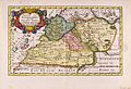
Map of Southern Morocco, 1705, by Nicolaas Sanson (Province of Darha/Draa with pink borders in the middle of the map)
-
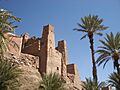
Kashbah in the Draa valley
-
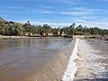
Draa river in Agdz


