
Drombeg stone circle facts for kids
|
Ciorcal an Droma Bhig
|
|

Drombeg site, looking south
|
|

Location in Ireland
|
|
| Alternative name | Druid's Altar |
|---|---|
| Location | County Cork, Ireland Irish Grid: W245352) |
| Coordinates | 51°33′52″N 9°05′13″W / 51.564553°N 9.08702°W |
| Type | Axial stone circle |
| Area | 9.3 metres (31 ft) (diameter) |
| Height | 1.8 metres (5 ft 11 in) (highest stone) |
| History | |
| Periods | Bronze Age to early Iron Age |
| Site notes | |
| Archaeologists | Edward M. Fahy (1957) |
| Management | National Monument Service |
| Public access | Yes |
| Reference no. | 381 |
The Drombeg stone circle is an ancient monument in County Cork, Ireland. It is also known as The Druid's Altar. This special stone circle is about 9 meters (29 feet) wide. You can find it about 2.4 kilometers (1.5 miles) east of Glandore.
The circle has 17 stones placed very close together. It is an "axial stone circle," which means it has two taller entrance stones. These are placed opposite a flat, lying-down stone. The circle is set up so it faces the setting sun.
Drombeg is one of the most popular ancient sites in Ireland. It is protected by law as a national monument. In 1958, archaeologists dug up the site. They found the ashes of a young person inside a pot in the middle of the circle.
What Makes Drombeg Special?

The stone circle has seventeen stones, but only 13 of them are still standing. The circle is about 9.3 meters (30.5 feet) across. The stone furthest to the west is a long, flat stone, about 1.9 meters (6.2 feet) long. It has two egg-shaped marks carved into it. One of these marks even has a ring around it.
This type of stone circle is called a "Cork–Kerry type." It has two tall stones, about 1.8 meters (5.9 feet) high, at the entrance. These stones point towards the southwest. This means the monument lines up with the setting sun during the middle of winter. The other stones in the circle are shaped to rise up towards the flat, lying-down stone. This flat stone's center was set to match the winter solstice sunset. This sunset can be seen through a special dip in the hills far away. The alignment is very good, but not perfectly exact.
Close by, about 40 meters (130 feet) west of the circle, you can see the remains of two old stone huts. There is also a "fulacht fiadh" (FOO-lacht FEE-ah). This was an ancient cooking place. People think the cooking place was used until about 500 AD. The bigger hut had a wooden roof. This roof was held up by a wooden post. The smaller hut had a cooking oven on its east side. A path leads from the huts to the cooking area. This area had a fireplace, a well, and a trough. Water was boiled in the trough by adding hot stones.
Digging Up the Past
People started studying the Drombeg site in the early 1900s. Then, in 1957, archaeologists dug up and fixed parts of the site. Scientists used a method called Radiocarbon dating. This method showed that the site was used between about 1100 BC and 800 BC.
During the dig, they found an upside-down pot in the center of the circle. Inside the pot were the ashes of a young person. These ashes were wrapped in thick cloth. The pot was buried near the center of the circle. They also found 80 broken pieces of pottery, four pieces of shale (a type of rock), and some ashes from a pyre (a pile of burning wood).
Gallery
-
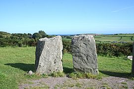
The tall portal stones
-
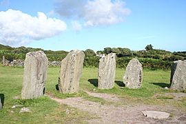
The eastern part of the circle
-
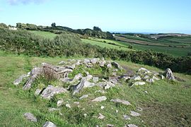
The ancient cooking place
-
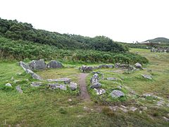
The remains of the old huts


See also
 In Spanish: Círculo megalítico de Drombeg para niños
