Du Pont, Georgia facts for kids
Quick facts for kids
Du Pont, Georgia
|
|
|---|---|

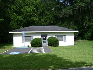
Du Pont Town Hall
|
|

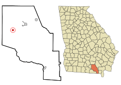
Location in Clinch County and the state of Georgia
|
|
| Country | United States |
| State | Georgia |
| County | Clinch |
| Government | |
| • Type | Mayor-council government |
| Area | |
| • Total | 0.78 sq mi (2.03 km2) |
| • Land | 0.78 sq mi (2.03 km2) |
| • Water | 0.00 sq mi (0.00 km2) |
| Elevation | 184 ft (56 m) |
| Population
(2020)
|
|
| • Total | 134 |
| • Density | 171.14/sq mi (66.10/km2) |
| Time zone | UTC-5 (Eastern (EST)) |
| • Summer (DST) | UTC-4 (EDT) |
| ZIP code |
31630
|
| Area code(s) | 912 |
| FIPS code | 13-24796 |
| GNIS feature ID | 0355562 |
Du Pont is a small town located in Clinch County, Georgia, in the United States. In 2020, about 134 people lived there. It is a quiet place with a history tied to the early railroads in Georgia.
Contents
History of Du Pont
The town of Du Pont started around 1856. Back then, it was called Lawton. It grew up along the route of a new train line called the Atlantic and Gulf Railroad. This railroad was important for moving goods and people.
During the American Civil War (1861-1865), a special train track was built from Lawton to Live Oak, Florida. This track was meant to help move soldiers and supplies for the Confederate side. However, it wasn't finished until 1865, just as the war was ending.
In 1874, the town's name was changed to Du Pont. It was named after an early settler named J. P. A. DuPont. The town officially became a city in 1889.
Where is Du Pont? (Geography)
Du Pont is located in the northwestern part of Clinch County, Georgia. You can find it at these coordinates: 30°59.4′N 82°52.3′W / 30.9900°N 82.8717°W.
U.S. Route 84 is a main road that goes right through the middle of Du Pont. If you go east on this road for about 8 miles (13 km), you will reach Homerville, which is the county seat (the main town for the county's government). If you go west for about 8 miles (13 km), you will get to Stockton.
The United States Census Bureau says that Du Pont covers a total area of about 0.8 square miles (2.03 square kilometers). All of this area is land, meaning there are no large lakes or rivers within the town limits.
How Many People Live Here? (Demographics)
The number of people living in Du Pont has changed over the years. This information comes from the U.S. Decennial Census, which counts everyone in the United States every ten years.
| Historical population | |||
|---|---|---|---|
| Census | Pop. | %± | |
| 1910 | 342 | — | |
| 1920 | 381 | 11.4% | |
| 1930 | 372 | −2.4% | |
| 1940 | 332 | −10.8% | |
| 1950 | 285 | −14.2% | |
| 1960 | 210 | −26.3% | |
| 1970 | 252 | 20.0% | |
| 1980 | 267 | 6.0% | |
| 1990 | 177 | −33.7% | |
| 2000 | 139 | −21.5% | |
| 2010 | 120 | −13.7% | |
| 2020 | 134 | 11.7% | |
| U.S. Decennial Census 1850-1870 1870-1880 1890-1910 1920-1930 1940 1950 1960 1970 1980 1990 2000 2010 |
|||
In the year 2000, a census counted 139 people living in Du Pont. These people lived in 57 different homes, and 42 of those were families. By 2010, the population had gone down a bit to 120 people. However, the most recent count in the 2020 census showed that the population had grown slightly to 134 people.
See also
 In Spanish: Du Pont (Georgia) para niños

