
Dunbar (CDP), Wisconsin facts for kids
Quick facts for kids
Dunbar, Wisconsin
|
|
|---|---|
|
Census-designated place
|
|

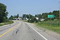
Looking west in downtown Dunbar on US8
|
|

Dunbar (CDP), Wisconsin
Location in Wisconsin
|
|
| Country | United States |
| State | Wisconsin |
| County | Marinette |
| Area | |
| • Total | 1.066 sq mi (2.76 km2) |
| • Land | 1.064 sq mi (2.76 km2) |
| • Water | 0.002 sq mi (0.005 km2) |
| Elevation | 1,306 ft (398 m) |
| Population
(2010)
|
|
| • Total | 50 |
| • Density | 47/sq mi (18.1/km2) |
| Time zone | UTC-6 (Central (CST)) |
| • Summer (DST) | UTC-5 (CDT) |
| ZIP code |
54119
|
| Area code(s) | 715 & 534 |
| GNIS feature ID | 1564171 |
Dunbar is a small community in Marinette County, Wisconsin, United States. It is known as a census-designated place, which means it's a special area defined for gathering population data. Dunbar is located on U.S. Route 8, about 12 miles (19 km) southwest of Niagara. It has its own post office with the ZIP code 54119. In 2010, the population of Dunbar was 50 people.
Images for kids
-
Sign on US8
-
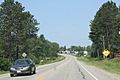
Panorama of the area
-
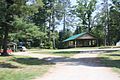
Veteran's Park in Dunbar
-
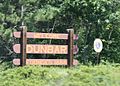
Welcome sign for Dunbar


See also
 Would you like to read about Dunbar in Spanish? Check out this article: Dunbar (condado de Marinette) para niños

All content from Kiddle encyclopedia articles (including the article images and facts) can be freely used under Attribution-ShareAlike license, unless stated otherwise. Cite this article:
Dunbar (CDP), Wisconsin Facts for Kids. Kiddle Encyclopedia.