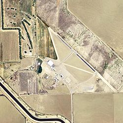
Eagle Field (airport) facts for kids
Quick facts for kids
Eagle Field
|
|||||||||||
|---|---|---|---|---|---|---|---|---|---|---|---|

USGS 2006 orthophoto
|
|||||||||||
| Summary | |||||||||||
| Airport type | Private | ||||||||||
| Owner | Eagle Field Airport LLC | ||||||||||
| Serves | Dos Palos, California | ||||||||||
| Elevation AMSL | 153 ft / 47 m | ||||||||||
| Coordinates | 36°53′59″N 120°40′04″W / 36.89972°N 120.66778°W | ||||||||||
| Website | https://www.eagle-field.org/ | ||||||||||
| Map | |||||||||||
| Runway | |||||||||||
|
|||||||||||
| Statistics | |||||||||||
|
|||||||||||
|
Source: Federal Aviation Administration
|
|||||||||||
Eagle Field is a private airport in Fresno County, California. It's about 8 miles (13 km) southwest of Dos Palos, California. This airport is special because it has a rich history, especially from World War II. It's still used today and even has a military museum.
Contents
The Story of Eagle Field
Eagle Field first opened on June 24, 1943, during World War II. It was a training airfield for pilots in the United States Army Air Forces. Back then, it was called Dos Palos Airport. It was part of the USAAF West Coast Training Center, which helped train many pilots for the war.
Training Pilots for War
The airport had three runways made of grass. They were used for planes to take off and land. Pilots learned to fly using planes like the Ryan PT-22. There were also PT-17 Stearmans and a few P-40 Warhawks. These were important planes for training and for fighting in the war.
Other Airfields Nearby
To help with all the training, there were several smaller airfields nearby. These were used for extra landings or in emergencies. Some of these auxiliary fields included:
- Hammond Auxiliary Field
- Vail Auxiliary Field (36°46′12″N 120°40′00″W / 36.77000°N 120.66667°W)
- Dos Palos Emergency Field (36°50′35″N 120°43′00″W / 36.84306°N 120.71667°W)
- Canal Field Auxiliary Field (36°56′34″N 120°47′20″W / 36.94278°N 120.78889°W)
- Mason Auxiliary Field (36°43′50″N 120°34′50″W / 36.73056°N 120.58056°W)
After the War
The pilot training program ended on December 28, 1944. Eagle Field was then used to store extra training planes. These included UC-78s, PT-17s, Vultee BT-13/15s, and AT-6 Texans. Later, the airport was given to the War Assets Administration.
For a short time after the war, the City of Dos Palos even had a golf course there. Eventually, the land went back to the federal government. In 1980, it was sold at an auction.
Eagle Field in Movies
You might have seen Eagle Field in a movie! It was used for a short scene in the film Indiana Jones and the Kingdom of the Crystal Skull.
Explore the Military Museum
Today, Eagle Field is home to the Central California Historical Military Museum. It's also known as Eagle Field AAF – WWII Living History and Military Museum. Many of the original buildings from World War II are still there. The museum is open to the public, so you can visit and learn about its history.
What You'll Find at Eagle Field Today
Eagle Field covers about 127 acres (51 hectares) of land. It sits about 153 feet (47 meters) above sea level. The airport has one runway, which is 2,300 feet (701 meters) long and 60 feet (18 meters) wide. It has an asphalt surface.
There are currently 8 aircraft based at Eagle Field. These include 6 single-engine planes, 1 multi-engine plane, and 1 jet aircraft.
Want to Learn More?
- California World War II Army Airfields
- 35th Flying Training Wing (World War II)


