East Layton, Utah facts for kids
Quick facts for kids
East Layton
|
|
|---|---|
|
Former city
|
|

Former city offices
|
|
| Country | United States |
| State | Utah |
| County | Davis |
| Incorporated | April 2, 1936 |
| Became a city | January 1972 |
| Merged with Layton | January 13, 1981 |
| Founded by | David Green |
| Named for | Christopher Layton |
| Area | |
| • Total | 2 sq mi (5 km2) |
| Elevation | 4,754 ft (1,449 m) |
| Time zone | UTC-7 (Mountain (MST)) |
| • Summer (DST) | UTC-6 (MDT) |
| ZIP code |
84040
|
| Area code(s) | 801 |
| GNIS feature ID | 1440835 |
East Layton was a small community in Davis County, Utah. It was right next to a bigger city called Layton. East Layton became an official town in 1936. This happened so they could get money to build a water system for everyone.
For many years, East Layton stayed a small town where people lived. It slowly grew and became a city in 1972. But in the 1970s, it grew very fast. Because of this quick growth, East Layton joined with Layton in 1981. Today, Layton is the biggest city in Davis County.
Contents
Where was East Layton located?
East Layton was located between Fairfield Road on the west and the Wasatch Mountains foothills on the east. Cherry Lane was the main street running through the town. Its borders were not perfectly straight. They reached as far north as Antelope Drive and as far south as Gentile Street.
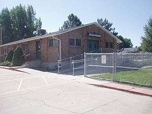
Inside the old city limits, you would find East Layton Elementary School. Also, Adams Reservoir was within its boundaries. The total area of East Layton was a little less than 2 square miles (5.2 km2). The city's offices were at 1010 N Emerald Drive. This building is now used as a daycare center.
How did East Layton start?
The area where East Layton was located was settled around the 1850s. This happened as people moved out from nearby Kaysville. When Layton became an official town in 1920, East Layton remained a separate, rural area. Only a few people lived there at first.
Why was the town founded?
Getting enough water was a big problem in Utah's desert climate. Wells and streams often dried up in the late summer. People had to carry water to their homes by hand. A resident named David Green had an idea. He wanted to build a municipal water system using water from Crooked Canyon. This canyon was in the Wasatch Mountains to the east.
By the 1930s, many neighbors liked Green's idea. But banks were not lending much money because of the Great Depression. Luckily, the federal government had a program called the Works Progress Administration (WPA). This program offered money for public works projects. However, only official towns or cities could get this funding.
In January 1936, 53 people from East Layton signed a petition. They wanted to form a town so they could get money for the water system. On April 2, 1936, the town of East Layton officially became a town. David Green became the first president of the town board.
In 1937, East Layton voters agreed to borrow money for the project. The WPA also approved the town's loan. But the money was slow to arrive. Town board members asked Henry H. Blood, who was the governor of Utah, for help. Governor Blood helped speed up the process.
David Green supervised the water project. Workers, paid by the WPA, laid pipes from Crooked Canyon. These pipes went down to a reservoir on Valley View Drive. A wooden trestle was built over a gorge. The ground was rough, making digging hard and slow. The project cost more than expected. The state of Utah gave more money. East Layton families also helped pay. The WPA ended up paying about 60% of the total cost.
How did East Layton grow and merge?
| Historical population | |||
|---|---|---|---|
| Census | Pop. | %± | |
| 1940 | 124 | — | |
| 1950 | 217 | 75.0% | |
| 1960 | 444 | 104.6% | |
| 1970 | 763 | 71.8% | |
| 1980 | 3,531 | 362.8% | |
East Layton started as a small, rural place. After it became a town, its population actually went down at first. It dropped from 160 people in 1936 to 124 in 1940. From 1940 to 1950, Layton's population grew five times bigger. But East Layton's population less than doubled. This slow growth was typical for most of the town's history.
The town built a bigger reservoir in 1963. They also added a sewer system and an even larger water system in 1969. In 1971, a special count showed 859 residents. This meant East Layton could become a third-class city in January 1972.
Even with more homes, East Layton never had many businesses. There were almost no stores in town. Residents had to shop in Layton or other nearby cities. In the 1970s, new housing developments caused huge growth. East Layton became an important place for people who worked at nearby Hill Air Force Base to live.
The city leaders had to provide services for a city that was suddenly four times bigger. With voter approval, they decided to join with the larger Layton City. The two cities merged on January 13, 1981. The East Layton area has continued to grow since then. It is still a mostly residential area, with many homes and people.
 | Claudette Colvin |
 | Myrlie Evers-Williams |
 | Alberta Odell Jones |


