East Parsonsfield, Maine facts for kids
Quick facts for kids
East Parsonsfield, Maine
|
|
|---|---|
|
Village
|
|

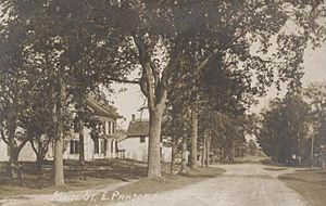
East Parsonsfield in 1917
|
|
| Country | United States |
| State | Maine |
| County | York |
| Elevation | 643 ft (196 m) |
| Time zone | UTC-5 (Eastern (EST)) |
| • Summer (DST) | UTC-4 (EDT) |
| ZIP code |
04028
|
| Area code(s) | 207 |
| GNIS feature ID | 565653 |
East Parsonsfield is a small community in the town of Parsonsfield, Maine. It's located in York County, which is in the southwestern part of Maine, United States. This village is considered an unincorporated area. This means it's a place with a group of homes and businesses, but it doesn't have its own separate local government like a city or a town. Instead, it's part of the larger town of Parsonsfield.
Contents
Exploring East Parsonsfield
East Parsonsfield is a quiet village that sits near the eastern edge of the town of Parsonsfield. It's close to the border with another town called Cornish.
What is an Unincorporated Village?
An unincorporated village like East Parsonsfield is a community that doesn't have its own official town council or mayor. It's still a recognized place where people live and work. However, its local services, like roads and schools, are managed by the main town it belongs to, which in this case is Parsonsfield.
Daily Life in East Parsonsfield
Even though it's a small community, East Parsonsfield has important services for its residents. One key feature is its own post office. This post office helps people send and receive mail, and it has a special ZIP code, which is 04028. This makes it easy for mail to reach the right homes and businesses in the area.
Where is East Parsonsfield Located?
You can find East Parsonsfield along Maine State Route 160. This road helps connect the village to other nearby towns and areas in Maine. The village's location in York County means it's part of a region known for its beautiful landscapes and historical towns.
 | Frances Mary Albrier |
 | Whitney Young |
 | Muhammad Ali |


