East Tawas, Michigan facts for kids
Quick facts for kids
East Tawas, Michigan
|
|
|---|---|
| City of East Tawas | |

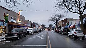
Downtown East Tawas along Newman Street
|
|

Location within Iosco County
|
|
| Country | United States |
| State | Michigan |
| County | Iosco |
| Settled | 1862 |
| Incorporated | 1887 (village) 1895 (city) |
| Government | |
| • Type | Council–manager |
| Area | |
| • Total | 3.27 sq mi (8.47 km2) |
| • Land | 2.81 sq mi (7.28 km2) |
| • Water | 0.46 sq mi (1.19 km2) |
| Elevation | 584 ft (178 m) |
| Population
(2020)
|
|
| • Total | 2,663 |
| • Density | 946.68/sq mi (365.50/km2) |
| Time zone | UTC-5 (Eastern (EST)) |
| • Summer (DST) | UTC-4 (EDT) |
| ZIP code(s) |
48730
|
| Area code(s) | 989 |
| FIPS code | 26-24420 |
| GNIS feature ID | 0625264 |
East Tawas is a city located in Iosco County, in the state of Michigan, United States. In 2020, about 2,663 people lived there. It's a fun place to visit and learn about!
Contents
History of East Tawas
East Tawas started because of the many trees in the area. In 1862, a company from New York bought land here. They wanted to use the wood from the forests. George Smith was one of the first people to settle in the community that year.
The East Tawas post office opened on April 15, 1867. This meant people could send and receive mail. A railway line was built here, which helped the town grow. East Tawas became a village in 1887. Later, it became a city in 1895.
A place called Tawas Beach was created nearby in 1903. It was also along the railway line. Tawas Beach had its own post office for a while. In 1922, Tawas Beach became part of the city of East Tawas.
Geography and Nature
East Tawas is a city with both land and water. The U.S. Census Bureau says the city covers about 3.27 square miles (8.47 square kilometers). Most of this area is land, but about 0.46 square miles (1.19 square kilometers) is water.
You can find Tawas Point State Park very close to East Tawas. This park is a great place to explore nature. It's known for its lighthouse and birdwatching.
Major Roads in East Tawas
- U.S. Route 23 runs right through the city. This highway helps people travel to and from East Tawas.
People of East Tawas
The number of people living in East Tawas has changed over the years. Here's how the population has grown:
| Historical population | |||
|---|---|---|---|
| Census | Pop. | %± | |
| 1880 | 1,086 | — | |
| 1890 | 2,200 | 102.6% | |
| 1900 | 1,736 | −21.1% | |
| 1910 | 1,452 | −16.4% | |
| 1920 | 1,398 | −3.7% | |
| 1930 | 1,455 | 4.1% | |
| 1940 | 1,670 | 14.8% | |
| 1950 | 2,040 | 22.2% | |
| 1960 | 2,462 | 20.7% | |
| 1970 | 2,372 | −3.7% | |
| 1980 | 2,584 | 8.9% | |
| 1990 | 2,887 | 11.7% | |
| 2000 | 2,951 | 2.2% | |
| 2010 | 2,808 | −4.8% | |
| 2020 | 2,663 | −5.2% | |
| U.S. Decennial Census | |||
East Tawas Population in 2010
In 2010, there were 2,808 people living in East Tawas. There were 1,332 households, which are groups of people living together. Many people lived alone, especially those aged 65 or older. The average age of people in the city was about 50.9 years old.
Schools in East Tawas
Students in East Tawas attend schools run by the Tawas Area Schools district.
There is also a private school called Holy Family School. It is a Catholic elementary school. About 80 students in grades K-6 attend this school.
See also
 In Spanish: East Tawas para niños
 | Kyle Baker |
 | Joseph Yoakum |
 | Laura Wheeler Waring |
 | Henry Ossawa Tanner |


