Eastmain River Airport facts for kids
Quick facts for kids
Eastmain River Airport
|
|||||||||||
|---|---|---|---|---|---|---|---|---|---|---|---|
| Summary | |||||||||||
| Airport type | Public | ||||||||||
| Operator | Transport Canada Cree Nation of Eastmain |
||||||||||
| Location | Eastmain, Quebec | ||||||||||
| Time zone | EST (UTC−05:00) | ||||||||||
| • Summer (DST) | EDT (UTC−04:00) | ||||||||||
| Elevation AMSL | 24 ft / 7 m | ||||||||||
| Coordinates | 52°13′35″N 078°31′21″W / 52.22639°N 78.52250°W | ||||||||||
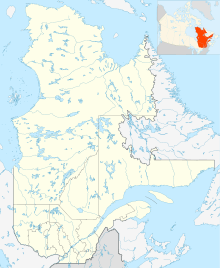
| Map | |||||||||||
| Runway | |||||||||||
|
|||||||||||
| Statistics (2010) | |||||||||||
|
|||||||||||
|
Source: Canada Flight Supplement
Movements from Statistics Canada |
|||||||||||
The Eastmain River Airport (IATA: ZEM, ICAO: CZEM) is a public airport. It is located about 1 nautical mile (1.9 kilometers) southwest of Eastmain, Quebec, Canada. This airport helps connect the remote community of Eastmain to other places. It is very important for travel and for bringing supplies to the area.
Contents
Eastmain River Airport
This airport is known by its special codes. ZEM is its IATA code. This code is used for things like airline tickets and baggage. CZEM is its ICAO code. This code is used by air traffic controllers. The airport is located near the community of Eastmain. Eastmain is a small place in the Canadian province of Quebec.
What is an Airport?
An airport is a special place where aircraft, like airplanes, take off and land. Airports have runways, which are long, flat areas for planes to use. They also have buildings called terminals. These are where passengers check in and wait for their flights. Airports are like big bus stations, but for planes!
Where is Eastmain River Airport?
The Eastmain River Airport is in Quebec, Canada. Quebec is a very large province. Many parts of Quebec are far from big cities. This airport helps people travel to and from these remote areas. It is especially important for the people living in Eastmain.
Who Operates This Airport?
The Eastmain River Airport is operated by two groups. One is Transport Canada. This is a government group that looks after transportation in Canada. The other operator is the Cree Nation of Eastmain. The Cree are an Indigenous group of people. They live in this part of Quebec. Working together, they make sure the airport runs smoothly.
What is a Runway?
Every airport needs a runway. A runway is a long, flat strip of land. Airplanes use it to speed up for takeoff. They also use it to slow down after landing. The runway at Eastmain River Airport is 3,512 feet long. That's about 1,070 meters. It is made of gravel, which is crushed rock.
Flights and Destinations
Even though it is a small airport, Eastmain River Airport has regular flights. These flights connect Eastmain to several other communities. The airline that flies here is called Air Creebec. It is an airline that serves many communities in northern Quebec and Ontario.
Air Creebec flies from Eastmain to places like:
- Chibougamau
- Chisasibi
- Kuujjuarapik
- Montreal–Trudeau (a major international airport)
- Nemaska
- Val-d'Or
- Waskaganish
- Wemindji
These flights are very important. They help people travel for work, school, or to visit family. They also help bring in supplies that the community needs.
Airport Statistics
In 2010, the Eastmain River Airport had 137 aircraft movements. An "aircraft movement" means one takeoff or one landing. So, 137 movements means planes took off or landed 137 times that year. This number shows how busy the airport was. It helps people understand how much the airport is used.
See also
 In Spanish: Aeropuerto de Eastmain River para niños
 | Toni Morrison |
 | Barack Obama |
 | Martin Luther King Jr. |
 | Ralph Bunche |


