
Eastvale, Pennsylvania facts for kids
Quick facts for kids
Eastvale, Pennsylvania
|
|
|---|---|

View of Eastvale taken from across the Beaver River
|
|

Location in Beaver County and the U.S. state of Pennsylvania.
|
|
| Country | United States |
| State | Pennsylvania |
| County | Beaver |
| Incorporated | 1892 |
| Government | |
| • Type | Borough Council |
| Area | |
| • Total | 0.12 sq mi (0.30 km2) |
| • Land | 0.09 sq mi (0.23 km2) |
| • Water | 0.03 sq mi (0.07 km2) |
| Elevation | 1,063 ft (324 m) |
| Population
(2020)
|
|
| • Total | 184 |
| • Density | 2,044.44/sq mi (785.47/km2) |
| Time zone | UTC-5 (Eastern (EST)) |
| • Summer (DST) | UTC-4 (EDT) |
| Area code(s) | 724 |
| FIPS code | 42-21968 |
Eastvale is a small town, also called a borough, located in Beaver County, Pennsylvania, United States. It sits right along the Beaver River. In 2020, about 183 people lived there. Eastvale is considered part of the larger Pittsburgh metropolitan area.
Contents
History of Eastvale
Eastvale was once known as "Fetterman." It officially became a borough on July 1, 1892. This means it became its own local government, separate from the bigger townships around it. The first time the government counted everyone living there was in 1900, and 256 people were recorded.
A post office served the community from 1897 to 1901. After that, mail for Eastvale has been handled by the Beaver Falls post office nearby.
The first bridge connecting Eastvale to Beaver Falls was built in the 1880s. This bridge was later replaced by the Eastvale Bridge in 1962, which is still used today. For a long time, Eastvale's economy depended on a factory that made bricks. This brickworks was located at the southern end of the borough, but it closed down by the mid-1970s.
Geography of Eastvale
Eastvale is located at coordinates 40.767765 degrees North and -80.314579 degrees West. It is right across the Beaver River from the city of Beaver Falls.
The United States Census Bureau says that Eastvale covers a total area of about 0.1 square miles (0.3 square kilometers). Most of this area is land, but about 33% of it is water. Eastvale is mostly a long, narrow strip of land that follows the Beaver River. It is actually the smallest town by area in all of Beaver County.
Neighboring Areas Around Eastvale
Eastvale shares land borders with two other townships:
- North Sewickley Township to the northeast.
- Daugherty Township to the southeast.
Across the Beaver River to the west, Eastvale is next to Beaver Falls. You can get to Beaver Falls directly using the Eastvale Bridge. This bridge is also part of Eastvale's main road, Pennsylvania Route 588.
Population of Eastvale
| Historical population | |||
|---|---|---|---|
| Census | Pop. | %± | |
| 1900 | 256 | — | |
| 1910 | 322 | 25.8% | |
| 1920 | 429 | 33.2% | |
| 1930 | 601 | 40.1% | |
| 1940 | 573 | −4.7% | |
| 1950 | 533 | −7.0% | |
| 1960 | 513 | −3.8% | |
| 1970 | 453 | −11.7% | |
| 1980 | 379 | −16.3% | |
| 1990 | 328 | −13.5% | |
| 2000 | 293 | −10.7% | |
| 2010 | 225 | −23.2% | |
| 2020 | 183 | −18.7% | |
| 2021 (est.) | 180 | −20.0% | |
| Sources: | |||
In the year 2000, there were 293 people living in Eastvale. These people lived in 125 households, and 81 of those were families. Most of the people living in the borough were White (about 97%). A smaller number were African American or from other backgrounds.
About 24% of the households had children under 18 living with them. The average household had about 2.34 people, and the average family had about 2.87 people.
The population had a mix of ages. About 21.8% were under 18, and 13.7% were 65 or older. The average age in the borough was 37 years old.
Education in Eastvale
Children who live in Eastvale attend schools that are part of the Big Beaver Falls Area School District. Before this school district was created in 1958 by combining smaller districts, Eastvale had its own school district.
Images for kids
-
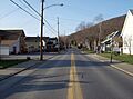
View along Second Avenue

See also
 In Spanish: Eastvale (Pensilvania) para niños
