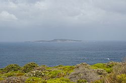
Eclipse Island (Western Australia) facts for kids

Eclipse Island is a small, rocky island in Western Australia. It is about 17 kilometers (11 miles) south of the city of Albany. The island is also about 6.1 kilometers (3.8 miles) south of the closest mainland coast. This point is called Cave Point on the Torndirrup Peninsula.
A tall structure called the Eclipse Island Lighthouse stands near the middle of the island. Close by, South West Island holds the southernmost land in Western Australia.
Contents
How Eclipse Island Got Its Name
Captain George Vancouver named Eclipse Island on September 28, 1791. He saw a partial solar eclipse that morning. Because of this special event, he decided to name the island "Eclipse Island."
A Special Nature Reserve
Eclipse Island is made mostly of granite rock. The island covers an area of about 99 hectares (245 acres). In the year 2000, it became a Class 1A Nature Reserve. This means it is a very important place to protect nature.
The island is also a landmark for the Volvo Ocean Race. This is a famous sailing race around the world.
The Eclipse Island Lighthouse
The island has a landing area about 30 feet (9 meters) above the water. This helps people reach the lighthouse. The lighthouse itself is 360 feet (110 meters) tall. It is also home to Western Australia's most southerly weather station. This station helps record important weather information. In 1950, four families used to live on the island.
Birds of Eclipse Island
Eclipse Island is a very important place for birds. It is known as an Important Bird Area. Many seabirds come here to nest and raise their young.
Thousands of flesh-footed shearwaters live on the island. There are between 6,000 and 8,000 pairs of these birds. The island also has a large number of great-winged petrels. About 10,000 to 15,000 pairs of these birds nest here.
Other birds you might find on the island include wedge-tailed shearwaters and little shearwaters. You can also see Caspian terns and Pacific gulls flying around.
Plants and Animals
Some animals and plants have been brought to the island by people. There is a large group of rabbits living on Eclipse Island. The arum lily, which is a type of plant, has also been introduced to the island.
 | Lonnie Johnson |
 | Granville Woods |
 | Lewis Howard Latimer |
 | James West |


