Edinburgh of the Seven Seas facts for kids
Quick facts for kids
Edinburgh of the Seven Seas
"The Settlement"
|
|
|---|---|
 |
|
| Sovereign state | |
| British overseas territory | |
| Island | |
| First inhabited | 1816 |
| Named | 1971 |
| Founded by | William Glass |
| Named for | Alfred, Duke of Edinburgh |
| Capital of | Tristan da Cunha |
| Population
(January 2020)
|
|
| • Total | 312 |
| Time zone | UTC+0 (GMT) |
| Area code(s) | +88 |
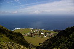
Edinburgh of the Seven Seas is the only town on the island of Tristan da Cunha. This island is part of a larger area called Saint Helena, Ascension and Tristan da Cunha, which is a British territory in the South Atlantic Ocean. People who live there often call it The Settlement or The Village.
History
The town of Edinburgh of the Seven Seas was started in 1816. A man named Sergeant William Glass from Scotland founded it. This happened after the United Kingdom took control of Tristan da Cunha.
A group of soldiers stayed on the island. Their job was to guard against any attempts to free Napoleon. He was a famous French leader who was held prisoner on Saint Helena. The soldiers stayed until the end of World War II.
The town got its name from Prince Alfred, Duke of Edinburgh. He was the second son of Queen Victoria. He visited the island in 1867, and the town was named in his honor.
Edinburgh of the Seven Seas is the main town on Tristan da Cunha. It has a small port, the home of the island's leader, and a post office. In 1961, a volcano erupted on the island. This caused damage to the town.
Everyone living there had to leave and go to Calshot, Hampshire in the UK. The eruption destroyed the town's factory that processed crayfish.
Most of the islanders came back in 1963. They rebuilt the town. The harbor in Edinburgh was named Calshot Harbour. This was to remember the place where they stayed during the eruption.
Geography
Climate
Tristan da Cunha has a wet oceanic climate. This means it has mild temperatures all year. But it also gets a lot of rain and not much sunshine. This is because of strong winds that blow from the west.
The weather is never extremely hot or cold. Frost is very rare unless you go high up the mountains. Summer temperatures are also mild, usually not going above 25 degrees Celsius (77 degrees Fahrenheit).
| Climate data for Tristan da Cunha | |||||||||||||
|---|---|---|---|---|---|---|---|---|---|---|---|---|---|
| Month | Jan | Feb | Mar | Apr | May | Jun | Jul | Aug | Sep | Oct | Nov | Dec | Year |
| Record high °C (°F) | 23.7 (74.7) |
24.4 (75.9) |
24.4 (75.9) |
22.4 (72.3) |
20.3 (68.5) |
18.7 (65.7) |
17.8 (64.0) |
17.3 (63.1) |
17.1 (62.8) |
18.4 (65.1) |
22.4 (72.3) |
21.8 (71.2) |
24.4 (75.9) |
| Mean daily maximum °C (°F) | 20.4 (68.7) |
21.2 (70.2) |
20.5 (68.9) |
18.9 (66.0) |
16.9 (62.4) |
15.3 (59.5) |
14.4 (57.9) |
14.2 (57.6) |
14.3 (57.7) |
15.4 (59.7) |
17.0 (62.6) |
18.9 (66.0) |
17.3 (63.1) |
| Daily mean °C (°F) | 17.9 (64.2) |
18.8 (65.8) |
17.9 (64.2) |
15.4 (59.7) |
14.6 (58.3) |
13.1 (55.6) |
12.2 (54.0) |
11.9 (53.4) |
12.0 (53.6) |
13.0 (55.4) |
14.6 (58.3) |
16.5 (61.7) |
14.8 (58.6) |
| Mean daily minimum °C (°F) | 15.4 (59.7) |
16.2 (61.2) |
15.3 (59.5) |
11.9 (53.4) |
12.3 (54.1) |
10.9 (51.6) |
10.0 (50.0) |
9.6 (49.3) |
9.7 (49.5) |
10.6 (51.1) |
12.2 (54.0) |
14.1 (57.4) |
12.4 (54.3) |
| Record low °C (°F) | 10.9 (51.6) |
11.8 (53.2) |
10.3 (50.5) |
9.5 (49.1) |
7.4 (45.3) |
6.3 (43.3) |
4.8 (40.6) |
4.6 (40.3) |
5.1 (41.2) |
6.4 (43.5) |
8.3 (46.9) |
9.7 (49.5) |
4.6 (40.3) |
| Average rainfall mm (inches) | 93 (3.7) |
113 (4.4) |
121 (4.8) |
129 (5.1) |
155 (6.1) |
160 (6.3) |
160 (6.3) |
175 (6.9) |
169 (6.7) |
151 (5.9) |
128 (5.0) |
127 (5.0) |
1,681 (66.2) |
| Average rainy days | 18 | 17 | 17 | 20 | 23 | 23 | 25 | 26 | 24 | 22 | 18 | 19 | 252 |
| Average relative humidity (%) | 79 | 77 | 75 | 78 | 78 | 79 | 79 | 79 | 78 | 79 | 79 | 80 | 78 |
| Mean monthly sunshine hours | 139.5 | 144.0 | 145.7 | 129.0 | 108.5 | 99.0 | 105.4 | 105.4 | 120.0 | 133.3 | 138.0 | 130.2 | 1,498 |
| Percent possible sunshine | 31 | 35 | 38 | 38 | 35 | 34 | 34 | 32 | 33 | 33 | 32 | 29 | 34 |
| Source 1: Worldwide Bioclimatic Classification System | |||||||||||||
| Source 2: Climate and Temperature | |||||||||||||
| Weather chart for Edinburgh of the Seven Seas | |||||||||||||||||||||||||||||||||||||||||||||||
|---|---|---|---|---|---|---|---|---|---|---|---|---|---|---|---|---|---|---|---|---|---|---|---|---|---|---|---|---|---|---|---|---|---|---|---|---|---|---|---|---|---|---|---|---|---|---|---|
| J | F | M | A | M | J | J | A | S | O | N | D | ||||||||||||||||||||||||||||||||||||
|
93
20
16
|
113
21
17
|
121
20
16
|
129
18
15
|
155
17
13
|
160
15
11
|
160
14
11
|
175
14
10
|
169
14
10
|
151
15
11
|
128
17
13
|
127
19
15
|
||||||||||||||||||||||||||||||||||||
| temperatures in °C precipitation totals in mm source: Climate and Temperature Information |
|||||||||||||||||||||||||||||||||||||||||||||||
|
Imperial conversion
|
|||||||||||||||||||||||||||||||||||||||||||||||
Transport
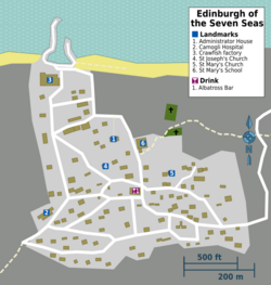
There is one main road in Edinburgh of the Seven Seas. People call it the "M1". This road connects the town to an important farming area called Potato Patches. Only a few private cars are on the island.
Paved paths allow people to walk easily to buildings around town. There is also a bus service. It is called the Potato Patches Flier. This bus is free for older residents. It takes them to the Patches and other stops along the road.
All cars and vehicles on the island have special license plates. They start with "TDC" followed by two or three numbers.
The town has a small harbor called Calshot Harbour. It was named after the village where the islanders stayed during the volcanic eruption. Only small boats can use the berths in the harbor.
About 10 ships visit the island each year. These ships bring tourists and residents. They travel to and from the island on trips that last several days. These trips usually start from South Africa or Namibia.
Art
A graphic artist named Rolf Weijburg created an etching of Edinburgh of the Seven Seas. He also made etchings of other places on the island of Tristan da Cunha.
Images for kids
See also
 In Spanish: Edimburgo de los Siete Mares para niños
 | Stephanie Wilson |
 | Charles Bolden |
 | Ronald McNair |
 | Frederick D. Gregory |


