
Egegik, Alaska facts for kids
Quick facts for kids
Egegik, Alaska
Igyagiiq, Igya'iq, Igyagiq
|
|
|---|---|
.jpeg)
Alaska Packers Association cannery at Egegik, 1917
|
|

Egegik, Alaska
Location in Alaska
|
|
| Country | United States |
| State | Alaska |
| Borough | Lake and Peninsula |
| Incorporated | 1995 |
| Area | |
| • Total | 128.50 sq mi (332.82 km2) |
| • Land | 29.55 sq mi (76.54 km2) |
| • Water | 98.95 sq mi (256.29 km2) |
| Elevation | 13 ft (4 m) |
| Population
(2020)
|
|
| • Total | 39 |
| • Density | 1.32/sq mi (0.51/km2) |
| Time zone | UTC-9 (Alaska (AKST)) |
| • Summer (DST) | UTC-8 (AKDT) |
| ZIP code |
99579
|
| Area code | 907 |
| FIPS code | 02-21150 |
| GNIS feature ID | 1401686 |
Egegik is a small city in Alaska, United States. Its name comes from the Sugpiaq language, where it is called Igya'iq or Igyagiq. Egegik is part of the Lake and Peninsula Borough.
In 2020, only 39 people lived in Egegik. This number was lower than in 2010, when 109 people lived there. For a long time, Egegik was an important place for fish processing factories called canneries.
Where is Egegik Located?
Egegik is found in a beautiful part of Alaska. It sits on the eastern shores of Bristol Bay and a smaller area called Egegik Bay. The village is built on a high cliff along the southern side of the Egegik River.
The city covers about 332 square kilometers (128 square miles). Most of this area is water, about 256 square kilometers (99 square miles). The land area is much smaller, around 76 square kilometers (30 square miles).
Who Lives in Egegik?
The number of people living in Egegik has changed a lot over the years. In 1880, about 120 people lived there. The population went up and down, reaching 203 people in 1900.
In recent times, the population has become quite small. In 2000, there were 116 people, and by 2020, it was down to 39.
Many of the people living in Egegik have Native American backgrounds. The community is made up of different families and individuals.
Images for kids
-
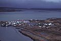
Egegik Village on the Alaska Peninsula
-
Homes of local people and a bidarka (a type of kayak) in Egegik, around 1917
-

Children in Egegik, 1917
-
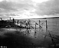
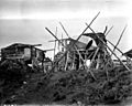
Traditional Alaskan fish traps at Egegik, 1917
-
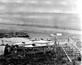
Bidarkas (skin-covered boats) on the beach at Egegik, around 1917

.jpeg)
.jpeg)
.jpeg)
on_the_beach_at_Egegik,_Alaska,_ca_1917_(COBB_128).jpeg)
See also
 In Spanish: Egegik (Alaska) para niños
