Eightmile, Oregon facts for kids
Quick facts for kids
Eightmile, Oregon
|
|
|---|---|

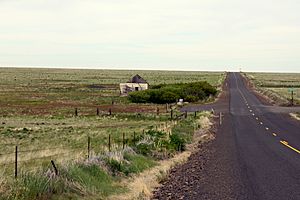
Abandoned building on Oregon Route 206 in Eightmile
|
|
| Country | United States |
| State | Oregon |
| County | Morrow |
| Elevation | 2,720 ft (830 m) |
| Time zone | UTC-8 (Pacific) |
| • Summer (DST) | UTC-7 (Pacific) |
| Area code(s) | 541 |
| GNIS feature ID | 1136248 |
Eightmile is a small, quiet place in Morrow County, Oregon, in the United States. It is known as an unincorporated community. This means it's a group of homes or buildings that doesn't have its own local government, like a city or town would. Instead, it's managed by the county.
You can find Eightmile along Oregon Route 206, which is also called the Wasco–Heppner Highway. It's a peaceful spot in the beautiful state of Oregon.
How Eightmile Got Its Name
The name "Eightmile" has a simple and interesting story. Early ranchers who settled in the area gave it this name. It was named after a nearby place called Eightmile Canyon.
This canyon got its name because its entrance was about 8 miles (or about 13 kilometers) up Willow Creek. This measurement was taken from where Willow Creek flows into the mighty Columbia River. So, the name "Eightmile" tells us exactly how far it was from a major river.
A Look at Its Past
Eightmile once had its own post office. This post office was first opened in the year 1883. It served the community for many years, helping people send and receive letters and packages. However, the post office eventually closed its doors in 1941. This often happens in small communities as populations change over time.
 | Kyle Baker |
 | Joseph Yoakum |
 | Laura Wheeler Waring |
 | Henry Ossawa Tanner |


