Willow Creek (Columbia River tributary) facts for kids
Quick facts for kids Willow Creek |
|
|---|---|

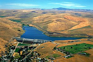
Willow Creek Lake, an impoundment of Willow Creek, with the city of Heppner below it
|
|
|
Location of the mouth of Willow Creek in Oregon
|
|
| Country | United States |
| State | Oregon |
| Counties | Morrow and Gilliam |
| Physical characteristics | |
| Main source | Arbuckle Mountain Blue Mountains, Morrow County, Oregon 4,351 ft (1,326 m) 45°09′56″N 119°20′29″W / 45.16556°N 119.34139°W |
| River mouth | Columbia River upstream of Arlington, Gilliam County, Oregon 269 ft (82 m) 45°48′21″N 120°00′24″W / 45.80583°N 120.00667°W |
| Length | 79 mi (127 km) |
| Basin features | |
| Basin size | 880 sq mi (2,300 km2) |
Willow Creek is a river in Oregon, United States. It flows for about 79-mile (127 km) (127 km). This creek is a branch of the mighty Columbia River. It helps drain an area of about 880 square miles (2,279 km2) (2,280 km2) in Morrow and Gilliam counties. Willow Creek starts in the Blue Mountains. It then flows mostly northwest until it joins the Columbia River near the town of Arlington.
Contents
Journey of Willow Creek
Willow Creek begins high up in the Blue Mountains. Its starting point is near Arbuckle Mountain. This is southeast of a town called Heppner. The creek first flows north, then turns west. Along its way, smaller streams join it. These include the North Fork and Skinners Fork.
Willow Creek Dam and Lake
A large structure called the Willow Creek Dam stands across the creek. This dam is about 160-foot (49 m) (49 m) tall. It creates a body of water known as Willow Creek Lake. This lake is just upstream from Heppner. The dam was built mainly to control floods.
Flowing Through Towns
After the dam, Willow Creek flows northwest through Heppner. Another stream, Hinton Creek, joins it there. About 10 miles (16 km) (16 km) downstream, the creek passes through Lexington. Soon after, Rhea Creek adds its waters to Willow Creek. The creek then travels through the communities of Ione and Morgan. Finally, it turns north and enters Gilliam County. It flows under Highway 74 and Interstate 84. Just after this, Willow Creek empties into the Columbia River. This meeting point is about 253 miles (407 km) (407 km) from where the Columbia River meets the Pacific Ocean.
Water Flow
The amount of water flowing in Willow Creek changes a lot. Sometimes, especially during dry periods, the creek can have very little water, even drying up in some spots. Other times, like after heavy rains or snowmelt, it can carry a huge amount of water. For example, in January 1974, the flow reached 16,900 cu ft/s (480 m3/s) (479 m3/s). On average, the creek flows at about 31.3 cu ft/s (0.89 m3/s) (0.89 m3/s) near Highway 74.
Willow Creek's Land Area
The area of land that drains into Willow Creek is called its watershed. This watershed covers about 880 square miles (2,279 km2) (2,280 km2) of Oregon. Most of this land, about 90 percent, is privately owned. Government agencies, like the United States Forest Service, own about nine percent. The state of Oregon owns the last one percent.
About 60 percent of the watershed is covered by forests, grasslands, or shrubland. Another 39 percent is used for growing crops. Only about one percent is city or town areas. The highest point in the watershed is about 5,583 feet (1,702 m) (1,702 m) high, near where the creek starts. The lowest point is at the creek's mouth, about 269 feet (82 m) (82 m) above sea level.
Temperatures in the watershed can vary a lot. They can drop below 0 °F (−18 °C) (–18 °C) in winter and rise above 110 °F (43 °C) (43 °C) in summer. The average temperature is around 50 °F (10 °C) (10 °C). The amount of rain and snow also varies. It can be as little as 8 inches (203 mm) (200 mm) in lower areas and up to 34 inches (864 mm) (860 mm) in the mountains.
Fish Life
You won't find anadromous fish (fish that swim from the ocean to freshwater to lay eggs, like salmon) in Willow Creek. However, Willow Creek Lake is home to several types of fish. These include small and largemouth bass, black crappie, brown bullhead, bluegill, and pumpkinseed fish.
History of Willow Creek
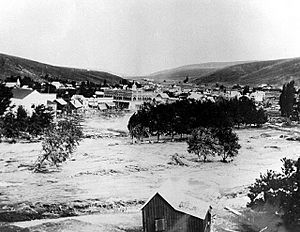
Willow Creek has a famous and sad history. On June 14, 1903, very strong thunderstorms hit the Heppner area. This caused a huge amount of rain and hail to fall. Within just fifteen minutes, a 40-foot (10 m) (12 m) wall of water rushed down Willow Creek. This sudden flash flood destroyed one-third of the buildings in Heppner. It tragically killed 247 people, making it the "most deadly natural disaster in Oregon's recorded history."
About 20 miles (30 km) (32 km) downstream, in the city of Ione, 150 homes were also destroyed. Luckily, people in Ione were warned by telephone and were able to get to safety. Because of this terrible event, the Willow Creek Dam was built in 1983. It is located just upstream from Heppner. The main purpose of the resulting Willow Creek Lake is to prevent such devastating floods from happening again.


