
El Ávila National Park facts for kids
The Ávila National Park is a special place in central-northern Venezuela. It's also known by its original name, Waraira Repano National Park. This park protects a part of the Cordillera de la Costa Central mountain range. The highest point in the park is Pico Naiguatá, which stands tall at 2,765 meters (about 9,072 feet) above the sea.
Quick facts for kids El Ávila National Park |
|
|---|---|
|
IUCN Category II (National Park)
|
|
 |
|
.svg)
El Ávila National Park
Location in Venezuela
|
|
| Area | 81,900 ha (316 sq mi) |
| Established | 12 December 1958 |
| Governing body | INPARQUES |
| Cerro El Ávila | |
|---|---|
| Highest point | |
| Elevation | 2,765 m (9,072 ft) |
| Geography | |
| Location | Caracas, Venezuela |
| Parent range | Cordillera de la Costa |
Contents
Fun Facts and Traditions
El Ávila is often called "the lungs of the city" by people in Caracas. It helps the city in many ways. For example, its peak helps people find their way around, marking the north side of Caracas.
The park is home to the longest cable car ride in the world! You can also enjoy many activities here. These include running, biking, rock climbing, camping, and even zip-lining. The famous Hotel Humboldt is nestled in the mountain's hills. You can also find many restaurants like La Chivera and Casa Pakea.
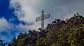
Every December, a large cross called the "Cruz de Navidad" lights up high on the mountain. It faces the city and can be seen from far away.
The Legend of Pacheco
People in Caracas often say "Pacheco has arrived" to describe when the seasons change. This comes from a story about Pacheco, a flower-picker. He lived in Galipán, a part of El Ávila near the coast. This area often had chilly weather, different from the hot, dry weather in the rest of the country.
Galipán was known for its beautiful and unique flowers. Every December, Pacheco would travel down the mountain into the city. He would sell his flowers in Plaza Bolivar in Caracas. His arrival often came with the cold December weather. Over time, the saying "Pacheco has arrived" came to mean that colder weather was on its way.
A Look Back in Time
El Ávila became a national park in 1958. People had wanted to protect this area since the 1800s. Making it a park helped protect the forests around Caracas, the capital city of Venezuela.
Today, these mountains are a great place for fun activities. They also help protect the city from pollution and too much building. El Ávila has always been important to the people of Caracas. They have used the area for many things.
A hotel and a cable car were opened in 1956. The cable car goes to a high point at 2,135 meters (about 7,005 feet) above sea level. It then goes down the other side to the city of Macuto. After being closed for 20 years, this cable car reopened in February 2002.
Amazing Plants and Animals
This park has a huge variety of plants and animals! Scientists have found more than 100 types of butterflies here. There are also about 120 kinds of mammals, 20 types of amphibians, and 30 types of reptiles.
The park is a birdwatcher's paradise with about 500 bird species. This is 36% of all the birds found in Venezuela! Nine bird species are found only in Venezuela. Three types of birds living here are also in danger. One of the most colorful birds in the park is the querrequerre (Cyanocorax yncas).
You can also see over 1,800 different kinds of plants. Many of these plants are found only in the Cordillera de la Costa mountain range. Some are even found only in El Ávila Park itself!
Different Types of Forests
The park's plants change depending on how high up you go.
- Dry Forests: From sea level up to 200 or 300 meters, you'll find dry forests. Plants like the cují (Prosopis juliflora) grow here.
- Sub-Evergreen Forests: Between 800 and 1,500 meters, there are sub-evergreen forests. These have two or three layers of trees and thick plants on the ground.
- Evergreen Forests: From 1,200 to 2,200 meters, you'll see evergreen forests. These have many types of orchids, ferns, and bromeliads. You can also find special plants found only in this area. These forests are home to the only natural group of the critically endangered Venezuelan walnut tree (Juglans venezuelensis).
- Grasslands: Some areas have grasslands where plants like melao capim and yellow tara grow.
- High Mountain Shrubs: In the highest parts, like Pico Naiguatá, there are short shrubs. These include the incense tree and Spanish flag plant.

What Threatens the Park?
El Ávila is considered vulnerable. This means its amazing plants and animals are at risk. If we don't watch over it, its biodiversity could be lost.
The biggest dangers to the park are forest fires and illegal settlements. These problems are mostly found near Caracas. However, because people focus on protecting areas close to the city, other parts of the park are less watched. The northern slope and eastern side of El Ávila have fewer signs, less equipment, and less security.
Other things that threaten the park include plants that don't belong there, the Caracas Aerial Tramway, the Hotel Humboldt, and illegal hunting.
Where is El Ávila?
El Ávila National Park is located along the central part of the Cordillera de la Costa mountain range. It stretches between the Caribbean Sea and the valleys of Caracas, Guatire, Guarenas, and Barlovento. The park covers parts of three states: Vargas (north side), Capital District (south and west sides), and Miranda (east side).

The park is named after the Cerro El Ávila (El Ávila Mountain). This mountain rises north of the capital city, Caracas. Caracas is in a narrow valley about 950 meters (about 3,117 feet) above sea level. The mountain separates the city from the Caribbean Sea.
You can reach the mountain by cable car (called teleferico), by off-road vehicle, or by walking. Besides the beautiful views, you can also visit the old home, lab, and mausoleum of Gottfried Knoche. He was a German doctor known for his experiments with mummification. You can only reach these places by walking trails.
The park is about 80 kilometers (50 miles) long and 16 kilometers (10 miles) wide. It covers over 81,800 hectares (about 202,132 acres). This huge area has many different types of environments. These change with the height, from 120 meters (about 394 feet) to 2,765 meters (about 9,072 feet) at Naiguatá peak.
The temperatures in El Ávila change a lot. The average temperature is about 13°C (55°F) in the lower parts near Caracas. It's about 10°C (50°F) on Naiguatá peak. The lowest temperature ever recorded there was 2°C (36°F).
Trails for Adventure
El Ávila National Park has many trails for people who love the outdoors. There's a trail for everyone, from easy walks to very challenging climbs!
Some of the most famous trails include: Los Venados, Sabas Nieves, El Vivero, Los Pinos, Papelón, Rancho Grande, Cachimbo, Miguel Delgado, Lomas del Cuño, El Paraíso, La Julia, Picacho, Piedra del Indio, Lagunazo, Pico Oriental, Pico Occidental, Cabeza de Elefante and Pico Naiguatá.
Images for kids
-
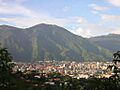
View of Caracas and Waraira Repano National Park.
-
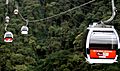
View of the El Ávila Cable Car starting from Caracas to Hotel Humboldt station
-
Way to Zamurera
-

Naiguata Cross
-
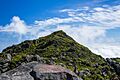
Naiguata Peak
-
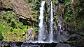
Paraiso Waterfall
-
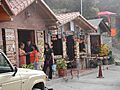
Galipan Village
-
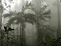
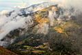
Cloudy forest
-
Cruz del Ávila
-
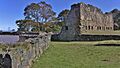
San Joaquín Fort
-
Hoyo de la Cumbre
-
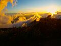
Sunset


.jpg)

See also
 In Spanish: Parque nacional El Ávila para niños
- Teleférico de Caracas
