El Bayadh Province facts for kids
Quick facts for kids
El Bayadh Province
ولاية البيض
|
|
|---|---|

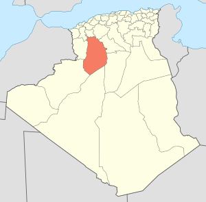
Map of Algeria highlighting El Bayadh
|
|
| Country | |
| Capital | El Bayadh |
| Area | |
| • Total | 78,870 km2 (30,450 sq mi) |
| Population
(2008)
|
|
| • Total | 262,187 |
| • Density | 3.32429/km2 (8.6099/sq mi) |
| Time zone | UTC+01 (CET) |
| Area Code | +213 (0) 49 |
| ISO 3166 code | DZ-32 |
| Districts | 8 |
| Municipalities | 22 |
El Bayadh Province is a large region in Algeria, a country in North Africa. It is named after its main city, El Bayadh, which is also its capital. This province is known for its wide-open spaces and unique landscapes.
Contents
Exploring El Bayadh Province
El Bayadh Province is located in the western part of Algeria. It covers a very large area, about 78,870 square kilometers. This makes it one of the bigger provinces in the country.
People of El Bayadh
According to a 2008 count, about 262,187 people live in El Bayadh Province. This means there aren't too many people living in each square kilometer. The province offers a lot of space for its residents.
What is a Province?
In Algeria, a province is like a state or a large county in other countries. It is a main administrative division. Each province has its own capital city and local government. This helps manage services and development for the people living there.
How El Bayadh is Organized
El Bayadh Province is divided into smaller parts to help manage it. These parts are called districts and municipalities.
Districts of El Bayadh
The province has 8 main districts. Think of these as larger regions within the province. Each district includes several smaller towns and villages.
- Boualem
- Bougtob
- Boussemghoun
- Brézina
- Chellala
- El Abiodh Sidi Cheikh
- El Bayadh
- Rogassa
Municipalities (Communes)
Within these 8 districts, there are 22 smaller areas called communes or municipalities. These are like local towns or city areas. They are the smallest units of local government.
Images for kids
See also
 In Spanish: Provincia de El Bayadh para niños
 | Roy Wilkins |
 | John Lewis |
 | Linda Carol Brown |


