El Cubo de Don Sancho facts for kids
Quick facts for kids
El Cubo de Don Sancho
|
||
|---|---|---|
|
||

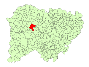
Location in Salamanca
|
||
| Country | Spain | |
| Autonomous community | Castile and León | |
| Province | Salamanca | |
| Comarca | Vitigudino | |
| Subcomarca | Tierra de Vitigudino | |
| Area | ||
| • Total | 91 km2 (35 sq mi) | |
| Elevation | 736 m (2,415 ft) | |
| Population
(2018)
|
||
| • Total | 450 | |
| • Density | 4.95/km2 (12.81/sq mi) | |
| Time zone | UTC+1 (CET) | |
| • Summer (DST) | UTC+2 (CEST) | |
| Postal code |
37281
|
|
El Cubo de Don Sancho is a small town in western Spain. It is located in the province of Salamanca. This area is part of the Castile and León region, which is one of Spain's 17 autonomous communities.
The town is about 66 kilometers (41 miles) away from Salamanca, the capital city of the province. As of 2018, about 450 people live in El Cubo de Don Sancho.
What is a Municipality?
A municipality is like a local government area. It is a town or city and the land around it. El Cubo de Don Sancho is one of many municipalities in Spain.
Geography of El Cubo de Don Sancho
This municipality covers an area of about 91 square kilometers (35 square miles). It is located 736 meters (2,415 feet) above sea level. This means it is quite high up! The postal code for the town is 37281.
Local Government
El Cubo de Don Sancho has a local government. The main leader is called the Mayor. The current Mayor is Emiliano Muñoz Corral. He is part of the People's Party. The Mayor helps make decisions for the town and its people.
See also
 In Spanish: El Cubo de Don Sancho para niños
 | James Van Der Zee |
 | Alma Thomas |
 | Ellis Wilson |
 | Margaret Taylor-Burroughs |


