El Ermitaño facts for kids
Quick facts for kids El Ermitaño |
|
|---|---|
 |
|
| Highest point | |
| Elevation | 6,146 m (20,164 ft) |
| Prominence | 1,344 m (4,409 ft) |
| Parent peak | Cerro El Condor |
| Geography | |
| Parent range | Chilean Andes, Andes |
| Climbing | |
| First ascent | 11/21/1967 - Sergio Kunsmann, Pedro Rosende, Etienne Vian (Chile) Heinz Koch (Germany) |
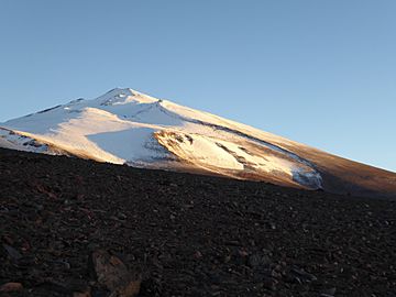
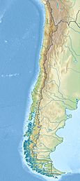
El Ermitaño is a very tall mountain in Chile. It stands 6,146 meters (about 20,164 feet) high. This impressive peak is located in a dry, high-altitude area called the Puna de Atacama.
El Ermitaño sits right on the border between two Chilean provinces: Chañaral and Copiapó. It is also found on the southern edge of a large, ancient volcanic crater. This crater is known as the Wheelwright Caldera. Another mountain, Cerro Peña Blanca, is nearby.
First Climb to the Top
Imagine being the first to reach the top of a giant mountain! El Ermitaño was first climbed on November 21, 1967. A team of four brave climbers made this historic ascent.
The team included Sergio Kunsmann, Pedro Rosende, and Etienne Vian from Chile. Heinz Koch from Germany was also part of this pioneering group. They were the first people known to stand on the very top of El Ermitaño.
How Tall is El Ermitaño?
The official height of El Ermitaño is 6,146 meters. This measurement helps us understand just how high this mountain reaches into the sky.
Scientists use different ways to measure mountains. For El Ermitaño, other measurements have been taken using special digital models. For example, one model called SRTM measured it at 6,134 meters. Another, ASTER, found it to be 6,113 meters. TanDEM-X measured it at 6,175 meters. These small differences show how tricky it can be to get an exact measurement of such a huge natural feature.
Mountain Features
El Ermitaño has a "topographic prominence" of 1,344 meters. This means it rises 1,344 meters above the lowest point connecting it to any higher mountain. Think of it as how much the mountain stands out from its surroundings.
Its "parent peak" is Cerro El Cóndor. A parent peak is the closest higher mountain that connects to El Ermitaño. The "topographic isolation" of El Ermitaño is 29.2 kilometers. This means it is 29.2 kilometers away from any point of equal or higher elevation.
See Also
 In Spanish: Volcán El Ermitaño para niños
- List of mountains in the Andes
- San Francisco Pass
 | Leon Lynch |
 | Milton P. Webster |
 | Ferdinand Smith |


